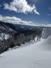
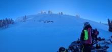
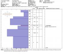
All Avalanche Incidents for Advisory Year 2022-23
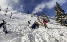
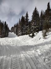
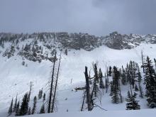
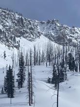
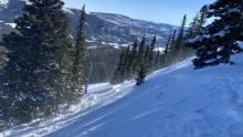
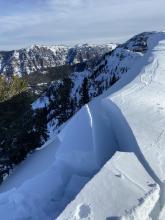
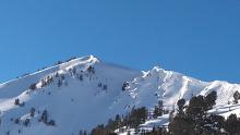
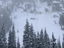
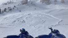
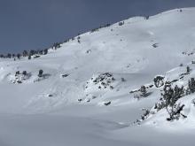
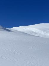
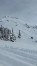
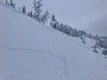
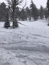
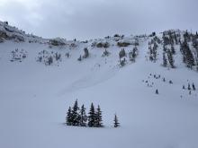
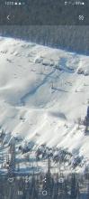
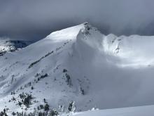
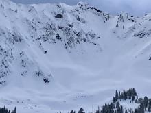
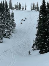
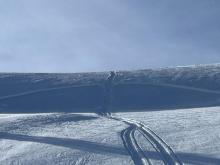
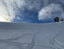
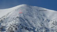
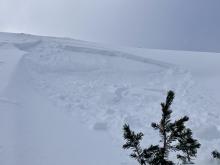
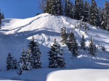
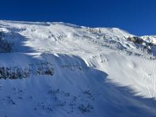
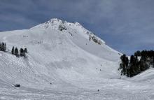
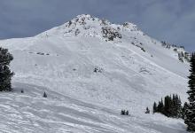
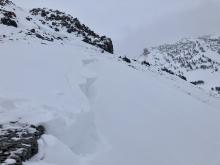
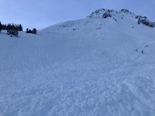
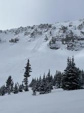
AMu-R3-D2-O
Elevation: 9,500
Aspect: E
Coordinates: 45.0773, -110.0210
Caught: 1 ; Buried: 1
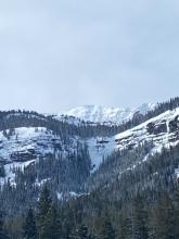
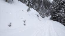
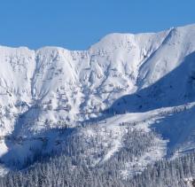
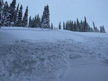
From email 2/26/23: "I just talked with a fella that reported his buddy was buried up to his chest in an avalanche yesterday off of east abundance, near the cliffs. He reported a 4' crown and 200' wide. His buddy was snowmobiling."
More Avalanche Details
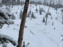
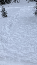
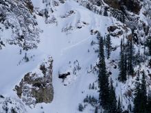
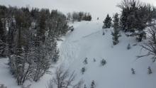
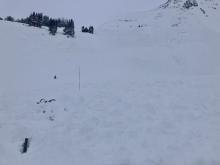
SS-ASu-R2-D1.5-S
Elevation: 9,400
Aspect: S
Coordinates: 45.0762, -109.9130
Caught: 1 ; Buried: 0
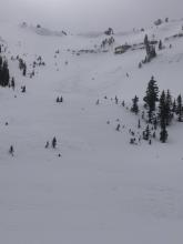
From IG message 2/25/23: "Hey just wanted to report a Cooke city avalanche from today. Happened at 3pm caused by a skier coming down a south facing slope above Round Lake. Everyone was fine, he lost his skis and everyone learned"
More Avalanche Details
SS-ASc-R2-D1-I
Coordinates: 45.0432, -110.9620
Caught: 0 ; Buried: 0
Triggered wind slab in southern Gallatins
More Avalanche Details

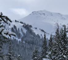
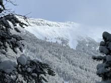
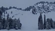
SS-N-R2-D2-O
Elevation: 9,700
Aspect: E
Coordinates: 45.0558, -109.9470
Caught: 0 ; Buried: 0
This natural avalanche was seen today on E. Henderson Bench.
More Avalanche Details
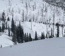
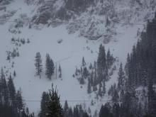
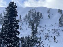
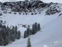
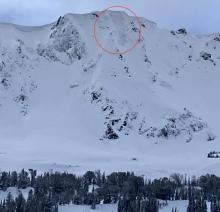
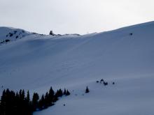
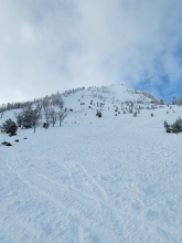
SS-N-R3-D2-O
Elevation: 9,400
Aspect: SW
Coordinates: 45.0398, -109.9400
Caught: 0 ; Buried: 0
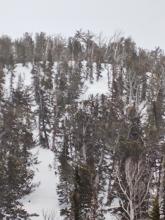
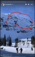
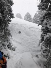
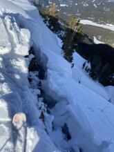
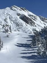
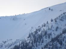
A snowmobiler saw this natural avalanche hit the Daisy Pass road within 10 minutes of riding by. He did a beacon search on the debris to confirm no one had been caught. It occurred about noon. This path is not very visible from the bottom and is not one that runs regularly. It killed a rider who was on the road in February 2012. The accident report has good photos of the path from afar.
Wind-loading in the start zone was the likely trigger since skiers and sledders do not access it.
From an email: "The crown was hard to see, but only looked a few feet deep where I could see it, but the debris pile was 10'+ on the road."
A big thanks to Dan Wykoff for providing the story and pictures.
More Avalanche Details
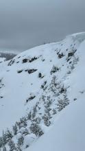
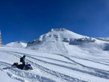
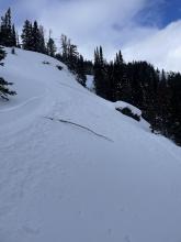
N
Elevation: 9,800
Aspect: W
Coordinates: 45.4472, -110.9620
Caught: 0 ; Buried: 0
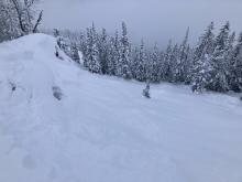
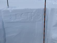
From Obs, "On Friday I noticed “Provo’s run” (large path near overlook mtn) slid from the top which appeared to have slid due to the heavy wind loading. The slid looked to be about 24” deep and ran full path . So today I checked out the west facing walls close the hyalite lake and around 9500’ the upper sections of these slid paths were wind effected and unstable, and I did not ride them
I dug a pit around 9500’ on the west facing wall near the lake and got unstable results. ECTP 11 which propagated below the recent wind load from last week.
the snow pack is 240 cm deep and is nice and consolidated without any major layers on several of the pits I dug at several elevations on these upper elevation"
More Avalanche Details
N
Coordinates: 45.0202, -109.9380
Caught: 0 ; Buried: 0
A group watched a natural avalanche from the Pilot Creek Parking area cascade down the mountainside on Friday, 2/24/23 at 5:00 PM.
More Avalanche Details

N-R3-D3
Elevation: 10,000
Aspect: E
Coordinates: 45.4160, -110.9980
Caught: 0 ; Buried: 0
From IG. “I spotted a large crown this morning on the E face of Bole. The crown appeared to be pretty deep, at least a few feet, and propagated quite wide. It also looked like there was a debris path coming down the apron of the E face of Hyalite peak, but I was too far away to know for sure.”
More Avalanche Details
SS-N-R1-D1.5-S
Elevation: 9,200
Coordinates: 44.7145, -111.3180
Caught: 0 ; Buried: 0
More Avalanche Details
HS-N-R2-D2.5-I
Elevation: 10,000
Aspect: NE
Coordinates: 45.2981, -111.5240
Caught: 0 ; Buried: 0
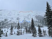
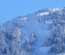
From email 2/25/23: "... a good sized slab avalanche on Fan, NE Face. Crown height hard to estimate but looked like a 2’ or so. Maybe running on interface from when it got cold earlier in the week? Possibly deeper than that but sure could have loaded that much this week. Anyway- very white bed surface, good propagation, 200’ -300’ crown length, debris stopped on upper bench. D2.5. Likely triggered by cornice fall."
More Avalanche Details
HS-N-R2-D2-I
Elevation: 9,500
Aspect: E
Coordinates: 45.4444, -111.0040
Caught: 0 ; Buried: 0
From IG: Skiers near Mt. Blackmore on 2/24 saw a large avalanche on the east side of Mt. Blackmore that appeared to have happened in the last 24 hours.
More Avalanche Details
N-R3-D2
Elevation: 9,000
Aspect: E
Coordinates: 45.2630, -110.7070
Caught: 0 ; Buried: 0
From IG message 2/24/23: HS-N-R2.5-D2-O. In emigrant gulch on an east aspect around 9k feet. Seemed to have stepped down on to a PWL, however it’s pretty tough to tell.
More Avalanche Details
C-N-R3-D2
Elevation: 9,300
Aspect: E
Coordinates: 45.3299, -111.3820
Caught: 0 ; Buried: 0
Came across this very large cornice that appeared to have broken naturally sometime in the past 24 hours. Saw a few others that had broken recently throughout our tour, but none as large as this.
More Avalanche Details
SS-AM-R3-D1.5-I
Elevation: 9,500
Aspect: NE
Coordinates: 45.1719, -111.3800
Caught: 0 ; Buried: 0
Triggered a small 2’ deep wind slab in new snow this afternoon. NNE aspect 9,500’, approximately 38° slope. Riding was excellent on all high North facing slopes and this was the only sign of instability we saw all day. Wind was howling on the way out, lots of snow coming out of the trees and transporting at ridge tops.
More Avalanche Details
Coordinates: 45.0709, -109.9580
Caught: 0 ; Buried: 0
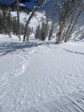
We rode to Round Lake, Goose Lake wilderness boundary and Lulu Pass. We saw a coulpe of small and very steep avalanches that released in the new snow. We dug 3 pits and got ECTX or ECTN28 on the new/old snow interface 2-3 feet under the surface. We were glad to not find propogation. Wind ramped up during the morning creating white-out conditions at time. At Lulu Pass we went to investigate wind slabs and got a collapse (whumf) when we stepped on it. Wind-loaded slopes are dangerous right now. Slopes ae actively loading and sensitive to triggering.
More Avalanche Details

AMu-R2-D2
Coordinates: 44.7145, -111.3180
Caught: 1 ; Buried: 1
From email 2/26/23: "I had heard a rumor from snowmobilers that there was a human triggered avalanche on Lionhead on Thursday the 23rd. While in Taylor Fork yesterday, we ran into one of the individuals that was a part of the incident.... he and a buddy were climbing together and he uncovered a rock that his buddy then hit. While the first rider continued to climb he triggered a slide, and it partially buried the second rider. He was able to deploy his airbag, but was carried approximately 100 yds down slope where he was buried. He was quickly found by other members of his group.
More Avalanche Details
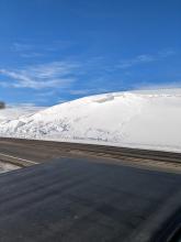
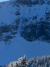
HS-N-R2-D1-I
Elevation: 6,900
Aspect: SE
Coordinates: 45.0034, -110.0430
Caught: 0 ; Buried: 0
As seen from the highway, Lamar Valley, SE aspect. Mid-morning today. -3°.
More Avalanche Details
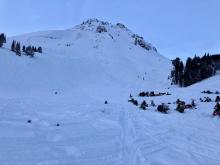
SS-N-R2-D2.5
Elevation: 10,000
Aspect: S
Coordinates: 45.0202, -109.9380
Caught: 0 ; Buried: 0
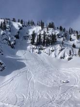
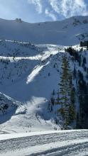
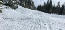
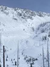
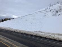
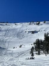
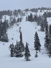
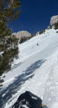
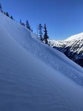
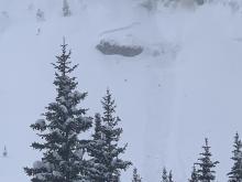
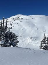
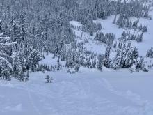
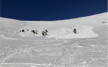
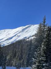
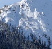
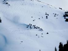
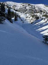
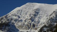
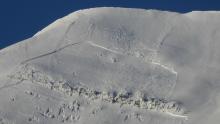
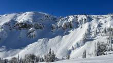
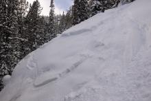
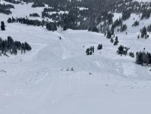
In Cooke City a large storm dropped 4.5" of snow water equivalent (4 feet of snow) and there were a few avalanches reported during and immediately after the storm. We saw one large avalanche on a south facing slope on Meridian, and a smaller wind-loaded slope that avalanched on Mt. Abundance (photo). We saw no other activity. Our concern is the interface between the old snow and new snow. The avalanche activity seemed to break here and on slopes with a wind-load it's worth being extra careful.
Meridian: R2, D2.5 (likely last night, 2/22)
Abundance: R3, D1.5 (maybe on 2/21)
More Avalanche Details

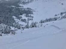
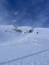
SS-N-R2-D2
Coordinates: 45.0034, -110.0430
Caught: 0 ; Buried: 0
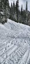
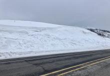
From an email:
Many collapses. HST 15cm. NSFing on the surface. Light winds out of the E, S.
Several small wind slab pockets in steep, wind loaded areas of terrain. This photo is the largest one that released. Bison, watch out!
On my drive back from the park, I noted a few others. Surprisingly, nothing on those S slopes around Meridian went.
-Old Man Rays, released mid slope, as well as a small pocket below the cliff in sympathy. SS-N-R2-D2-I(?)
-Miller Ridge, SW aspect at about 9500’, large crown. That’s all I could see.
More Avalanche Details
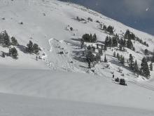
SS-N-R2-D2-I
Aspect: NE
Coordinates: 45.0202, -109.9380
Caught: 0 ; Buried: 0
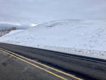
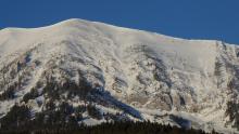
Photos of some recent natural avalanches near Cooke City today attached. All of the slides observed appeared to just involve new snow from the Feb. 20-21 storm. (occuring on all aspects, but primarily on NE aspects)
New snow: generally about 50-80cms of settled new snow from Feb. 20-21.
Quite a bit of collapsing experienced today while breaking trail, particularly in the lower elevations.
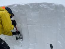
Snowpit attached from a SE aspect at 8500'. HS: 170.
ECTP15- 55cms down, at new/old interface.
_____________________________________
from 23 February email:
More Avalanche Details
N-D2.5
Aspect: N
Coordinates: 45.0202, -109.9380
Caught: 0 ; Buried: 0
Residents of Silver-Gate caught a glimpse of a large natural avalanche south of Silver Gate on Wall Mountain. The size is uncertain, but it knocked down a stand of trees. Two people state that they believe they heard the avalanche in the pre-dawn hours.
More Avalanche Details
Elevation: 9,800
Aspect: W
Caught: 0 ; Buried: 0
From IG: “Ski cut trigger. West facing. 9800ft. Big sky area.”
More Avalanche Details
SS-N-R2-D2-I
Elevation: 9,400
Aspect: NE
Coordinates: 45.1719, -111.3800
Caught: 0 ; Buried: 0
We rode through First and Second Yellowmule at Buck Ridge. There was a natural avalanche below the cornice line on the headwall above second Yellowmule that broke within the last 12 hours as it was not covered by any new snow. From a distance, it looked ~200' wide and broke 1-3' deep. I believe it failed under the storm snow, not of deeper weak layers.
More Avalanche Details


N
Coordinates: 45.8512, -110.9480
Caught: 0 ; Buried: 0
From Marienthal Observation: "Drove up to Bridger at noon and saw a large avalanche on along the road north of the fire station. It was 75’ wide, 1-1.5’ deep and 25’ vertical. HS-N-R4-D1.5/2. It was on an east facing slope, south of the long slope that has cornices. The slope with cornices hadn’t slid at this point. On the way home at 3:30 the larger slope with cornices had slid. It was very big, possibly R5. 1.5-2’ deep, 200’ wide, huge chunks of hard slab and cornice. Looks like new wind-loaded snow with some gouges into older snow.
From Olson creek I had a cloud-free flat light view of the ridge from Saddle to Bridger Peak and looked with binoculars. There was a wind slab just north of quarter saddle that did not go over the cliffs. Probably 1-2’ deep, 30’ wide of new snow. There was a large wind slab on the north half of Between the Peaks (250’ wide) and one similar depth wind slab in the Pinnacles (100’ wide). Both of these broke 1-3’ deep immediately below the cornice and did not entrain much snow or propagate very wide or downslope given how much new snow there was. I could see the debris from the slide between the peaks which ran over 1000’ vertical to the top of the runout zone but relatively low volume."
More Avalanche Details
SS-N-R2-D2-I
Elevation: 9,900
Aspect: E
Coordinates: 44.9739, -109.9240
Caught: 0 ; Buried: 0
From email, "At 12:45 p.m. I saw Climax run naturally. SS-N-R2-D2-I. The low visibility and distance made it hard to tell how deep the crown was, but based on there not being much volume of debris and it not running very far I’m guessing it was within the new snow/storm interface and didn’t step down to any buried PWL."
More Avalanche Details
SS-AMu-R2-D1.5-I
Coordinates: 45.0772, -110.0210
Caught: 1 ; Buried: 0
A snowmobiler triggered an avalanche on a wind-loaded slope near Mount Abundance and was carried downhill. The sled hit a tree but the rider was not buried or injured.
More Avalanche Details

SS-ASc-R1-D1-I
Elevation: 8,000
Aspect: SW
Coordinates: 45.9126, -110.9550
Caught: 0 ; Buried: 0
Triggered a couple small slides on the cornices that typically form in the corridor here: 45.91263, -110.95506
wind was blowing in strong gusts and it started snowing very heavy around 1pm
super reactive. Approached the small slope and the whole thing went. It was only 2-3 inches deep. Likely from wind blown today and some of what was falling. It did run for about 40-50 wide. Nothing that would bury a person but definitely a telling sign.
More Avalanche Details
AS-R1-D1
Coordinates: 45.8322, -110.9280
Caught: 0 ; Buried: 0
About 34 degree rollover, 14 inch crown.
More Avalanche Details
SS-AM-R2-D2
Coordinates: 45.0202, -109.9380
Caught: 0 ; Buried: 0
Riders north of Cooke City on 2/16/23 saw an avalanche that appeared to be recently snowmobile triggered on Crown Butte.
More Avalanche Details


Coordinates: 45.4160, -110.9980
Caught: 0 ; Buried: 0
Saw debris and what looked like a crown line from a natural avalanche that probably happened a day or two ago in palace butte basin on a NE aspect above Arden lake. My best guess is 150ft wide crown, 1-2ft deep?
More Avalanche Details
SS-AM-R1-D1
Aspect: E
Coordinates: 44.7265, -111.3170
Caught: 0 ; Buried: 0
Airplane Bowl.
More Avalanche Details
SS-N-R1-D1
Elevation: 9,200
Aspect: E
Coordinates: 45.1719, -111.3800
Caught: 0 ; Buried: 0
Small storm slab released on a small piece of terrain. East aspect around 9200.
More Avalanche Details
SS-N-R1-D1.5
Elevation: 10,000
Aspect: N
Coordinates: 45.4444, -111.0040
Caught: 0 ; Buried: 0
Low winds/no snow transport when I was up there and the east face had little to no wind effect, probably 16-18in new snow. Saw this slide with about a 8-12in crown and 100ft wide on the north face, didn’t see any other activity aside from some small point releases on really steep east aspects.
From another party: Saw a sizable avalanche on the north east face of Blackmore, likely broke mid storm and was partly filled in already - estimated 20" deep, 100' wide. Had shooting cracks and collapsing while ascending northeast ridge. Hand pits showed planar results on an 8" harder slab beneath all the blower on top.
More Avalanche Details
SS-N-R1-D1
Elevation: 6,000
Coordinates: 45.5686, -111.0090
Caught: 0 ; Buried: 0
We observed a few small crowns on steeper road cuts in Sourdough today, NW and W aspects. 4-8" at crown, 20-40' wide, ~10' vertical. They looked like storm slabs that had run overnight, maybe on a density change in the storm snow. Debris piles were small and covered with 2-3" of new snow. Low consequence, but maybe enough to surprise a kid or a dog. Photos were taken shortly above the 2 mile marker.
More Avalanche Details
SS-ASu-R1-D1
Coordinates: 45.4892, -111.0050
Caught: 0 ; Buried: 0
Was about 80% of the way up to the top of the middle meadow on history rock this morning when we remotely triggered a small avalanche from the skin track. Slide was just new snow that had fallen within prior 24hrs. Crown of about 8 inches, 20ish feet wide by 20 feet long. Face that slid was east facing. We took this as a sign to reconsider skiing something even as low key as history rock and decided to ski the skin track back.
[Dropped the pin for this observation exactly where I believe the observation to have occurred. Took an OnX waypoint while out there to help too.]
More Avalanche Details
SS-ASu-R1-D1
Elevation: 8,700
Aspect: SW
Coordinates: 45.3407, -111.3910
Caught: 0 ; Buried: 0
In Beehive with AAI Pro 1. Storm snow measured at over 30 cm, roughly double what was reported at Big Sky/YC. 5% density. Wind Slabs slowly building from L to M N winds, both WS and Loose Dry touchy on all slopes steeper than 35 with a MFcr as the interface - basically everything W, S, E aspects below 9500 (probably above too but we didn't go that high). One skier triggered wind slab observed low in the "tyler's" slide path on a SW aspect, 8700 ft, 35 deg, SS-ASu-R1/D1-I. No evidence of active persistent slab, 11x pits @ 8500 SE, HS 170, ECTX for all.
More Avalanche Details
SS-N-D1
Coordinates: 45.4402, -110.9310
Caught: 0 ; Buried: 0
Went for a ski up the Flanders drainage in Hyalite today. The day was punctuated by light winds and heavy snowfall.
On the skin in, we noted numerous D1 storm slab avalanches about 15cm down in the new snow on many aspects and elevations. Approaching a ridgeline, we experienced a shooting crack that propagated a very small slide in slightly wind affected snow. We dug an ECT on a SE facing aspect at 9000ft. We were unable to get propagation. Snow totals appeared to be higher than forecasted, with 60cm of new snow as of about 12:30. By the time we ripped skins, the area had received an additional 10cm of snow, putting totals around 60-70cm of low density snow on top of a stout melt freeze crust on the aspect we were skiing.
we did not observe any cracking collapsing or wumphing in buried weak layers, nor signs of avalanches on those layers. The new snow had very low SWE.
More Avalanche Details
Coordinates: 45.5243, -110.9560
Caught: 0 ; Buried: 0
Just a little more than 4-7” snow in Hyalite this morning
I skied at Lick Creek area and there’s 18-24” and still dumping
Low density
In the meadows I skied (not the Main meadow - too far to break trail) snow is on pretty firm melt / freeze crust. Heard a few whumps skinning up
More Avalanche Details
C-ASu
Elevation: 9,600
Aspect: NE
Coordinates: 45.4434, -110.9970
Caught: 0 ; Buried: 0
Also of note, as we traversed a corniced ridge later in the day, two of our group members simultaneously came too close to the edge of a cornice and it broke away, but did not fall down the slope. Fortunately, everyone was alright, but it was a close call and we will definitely be more mindful next time. We believe the cornice was made more sensitive by the warm weather over the past few days.
More Avalanche Details
SS-N-R2-D1
Elevation: 8,000
Aspect: SW
Coordinates: 44.8670, -111.2410
Caught: 0 ; Buried: 0
On 2/12/23 Riders saw "Seemed to be a decent sized slide runoff was pretty deep where it stopped in the trees figured it was probably two days old. Southwest facing. Roughly 44.86695° N, 111.24123° W"
More Avalanche Details
SS-ASr-R1-D1-S
Elevation: 8,400
Aspect: SE
Coordinates: 45.5097, -111.0820
Caught: 0 ; Buried: 0
We also observed a most likely remote triggered small wind slab (not our tracks next to it). Solar aspects were hot. Top of snowpack was relatively stable in our 4 foot pit, some collapse but no propagation (E aspect, 8400 feet).
More Avalanche Details
N-R1-D2
Elevation: 10,000
Aspect: SW
Coordinates: 45.0202, -109.9380
Caught: 0 ; Buried: 0
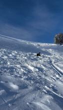
2/10/23: Our group did a big loop - Daisy- wolverine- goose - sheep -lulu. Saw minimal wind transport except on high points ( see photo). After looking all day saw an R1D2 slide (see 2nd photo) on a ENE slope above 10,000' south of Lulu pass, unknown trigger, though the whole area around the slide had cornice growth. We observed a lot of tracks highmarking into windloaded alpine slopes but saw no rider triggered avalanches.
More Avalanche Details
SS-N-R1-D1
Coordinates: 45.0251, -109.9760
Caught: 0 ; Buried: 0
On our 3rd lap on the North Side Burn in Sheep Creek, we traveled up the ridge to take a look at the steeper terrain to the west along the ridge. From our protected vantage point, we could see a recent wind slab that appeared to release naturally some in the past 24 hours. The crown was obscured, but I would code the avalanche as SS-N-R1-D1-S. The avalanche was approximately 3-6" deep, 25' wide, and ran for ~60'.
More Avalanche Details
SS-AMu-R1-D1
Coordinates: 44.9041, -111.1850
Caught: 0 ; Buried: 0
This afternoon my group of 4 was riding up out of Tepee Creek heading towards Cabin Creek and I set off this small slide on a northeast facing slope as I was coming down it. The slide broke about a foot deep on top of the packed layer of snow and was 150-200' wide at the crown. Thankfully it slid slowly, less than 100' and I was able to ride out of it.
More Avalanche Details

AMu
Coordinates: 44.6249, -111.2590
Caught: 0 ; Buried: 0
From FB: Had some tourists in the shop trigger an avalanche on two top yesterday. Didn't get exactly where or much details. Steep tracked up slope they set off. Just a partial sled burial.
More Avalanche Details
HS-N-R2-D1-O
Elevation: 6,000
Aspect: E
Coordinates: 45.7211, -110.9100
Caught: 0 ; Buried: 0
One maybe two distinct seemingly natural large natural slab avalanches on small slope directly next to bridger canyon drive. One on the lookers left was likely cornice triggered, but on the right it's unclear to me if it propagated or released naturally.
More Avalanche Details
SS-AFc-R2-D1-O
Elevation: 9,000
Aspect: E
Coordinates: 44.5658, -111.5000
Caught: 0 ; Buried: 0
We rode up Yale Creek and into Mt Jefferson Bowl. Walking to the edge we triggered an avalanche (intentional) on a slope that was getting wind-loaded. It broke up to 1.5 feet deep, 250 feet wide and 50 feet vertical. The new wind drifts were sensitive to triggering and the slabs propagated wide. Weak layers at the old snow surface may have helped us remotely trigger the slope. The two things to look out for in the Centennials are weak layer of sugary snow or feathery surface hoar in the upper 3 feet of the snowpack and slopes that are freshly wind-loaded.
More Avalanche Details


Coordinates: 44.9277, -111.2430
Caught: 0 ; Buried: 0
From FB: We saw a fresh break on the west face of sage peak last night, I would guess around 9500’.
More Avalanche Details
HS-AMu-R2-D1-O
Elevation: 9,500
Aspect: E
Coordinates: 45.0722, -109.9280
Caught: 0 ; Buried: 0
We rode north of Round Lake this morning (2/6/23)....
There was a small snowmobiler triggered slide on a convex bench between Sheep Mtn. and Round Lake that was triggered this afternoon. It was 1.5-2' deep, 30' wide, and looked to have broke on a weak layer below last week's snow, on a freshly wind-loaded slope. In a relatively shallow, rocky area (photo attached).
More Avalanche Details

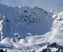
HS-ASu-R2-D2-O
Elevation: 10,000
Aspect: N
Coordinates: 45.3810, -110.9610
Caught: 1 ; Buried: 0
Me and a buddy were out skiing/camping in the Hyalite Lake area. Late Saturday afternoon we started skinning up towards Hyalite Peak. The path up to the ridge was super hardpacked and windswept. We got up and there was quite a bit of snow loaded above the north slope. I dropped over the side and took about two turns before the entire face above me released from the very top and traveled down the entire north side down to the bowl below. I was able to get to the rocks on the side and my partner was able to pick his way down. The crown looked a few feet deep from what I could see and stretched across the entire top of the line.
More Avalanche Details

SS-ASc-R1-D1
Elevation: 8,000
Aspect: SE
Coordinates: 45.3186, -111.2560
Caught: 0 ; Buried: 0
Toured/ skied on S though E aspects between 6000' and 8200' and observed the following:
...
-Several localized whumphs
...
-Stomped one freshly wind-loaded rollover on micro-terrain and released a small (15 cm - 30cm thick) windslab
More Avalanche Details
SS-ASu-R2-D2-I
Elevation: 9,700
Aspect: SW
Coordinates: 45.0661, -109.9590
Caught: 1 ; Buried: 1
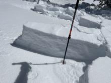
Dug at South facing snowpit at 9700' near the base of a wind-loaded slope, ECTX HS:280. Continued on less than 200' up the slope, the skier breaking trail triggered the avalanche. The third skier in the group of five was caught, carried, and buried to the waist. The crown was 1-2' deep, and 50 feet wide. Location: South of Fisher Mountain. Yesterday triggered a small windslab on a north-facing slope on miller ridge, no one was involved.
More Avalanche Details
SS-AS-I
Coordinates: 45.2777, -111.4510
Caught: 0 ; Buried: 0
A 2’ storm snow avalanche in the Chippewa Notch area was apparently triggered by a rider. It propagated significantly across complex terrain, and ran through plenty of terrain traps/trauma trees.
More Avalanche Details
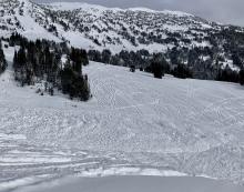
SS-AM-R2-D1
Coordinates: 45.0773, -110.0210
Caught: 0 ; Buried: 0
We triggered this very small slide on a steep convex rollover by mt abundance. South facing. Triggered from on top by snow bike. Was only 60’ wide and didn’t run far at all. About a foot deep. Some impressive high mark tracks in the area. No other signs of instability today.
More Avalanche Details
SS-AMu-R3-D2-I
Elevation: 9,300
Aspect: NE
Coordinates: 45.1719, -111.3800
Caught: 0 ; Buried: 0
From FB message: I triggered this one Thursday night (2/2/23). Got lucky it didn't gain speed and sack on itself. Been in this zone 1000 times, never seen it slide, always gotta be on your game... NE aspect in Beaver Creek.
More Avalanche Details

AS
Coordinates: 45.2777, -111.4510
Caught: 1 ; Buried: 0
Big Sky Ski Patrol reported a skier triggered avalanche in "The Mullet" in the backcountry outside the ski resort boundaries. One skiers was reportedly caught and carried by the slide. The initial skier triggered slide also triggered another avalanche in the adjacent "Rattail" avalanche path. Details are second hand and specifics could not be confirmed due to low visibility.
More Avalanche Details
Coordinates: 45.0265, -111.0480
Caught: 0 ; Buried: 0
Skiers reported getting several whumpfs in a thin snowpack in Specimen Creek.
More Avalanche Details
AS
Coordinates: 45.0202, -109.9380
Caught: 0 ; Buried: 0
Skiers northwest of Cooke City reported several collapses while they were breaking trail.
More Avalanche Details
SS-N
Coordinates: 45.4472, -110.9620
Caught: 0 ; Buried: 0
A snowboarder noticed several small slides on the east-facing walls of the Main Fork of Hyalite Creek and a small slab avalanche in the back of the Divide Peak basin.
More Avalanche Details
HS-AE-R3-D3-O
Aspect: E
Coordinates: 45.7943, -110.9360
Caught: 0 ; Buried: 0
From BBSP: "Most of the Football Field pulled with the top Bitter End shot."
More Avalanche Details
HS-AMr-R3-D1.5-I
Elevation: 8,900
Aspect: NE
Coordinates: 44.7296, -111.3200
Caught: 0 ; Buried: 0
As we rode into Lionhead we saw many slides that either ran naturally or from cornice falls (separate avalanche log record). Most of the slides happened Fri or Sat. Winds are blowing strong at all aspects and elevations. Slopes are being loaded further and we triggered a small slide (video) from 50 feet away (aka remotely triggered). This is a serious sign of instability and we were careful to not get on or underneath avalanche terrain.
More Avalanche Details

HS-N-R2-D2-U
Elevation: 9,200
Coordinates: 44.7145, -111.3180
Caught: 0 ; Buried: 0
As we rode into Lionhead we saw many slides that either ran naturally or from cornice falls. Most of the slides happened Fri or Sat. Winds are blowing strong at all aspects and elevations. Slopes are being loaded further and we triggered a small slide (video) from 50 feet away (aka remotely triggered)(separate avy log record). This is a serious sign of instability and we were careful to not get on or underneath avalanche terrain.
On Feb 11 we saw evidence of widespread activity that likely occurred during this cycle on 1/29-1/30.
More Avalanche Details
SS-NC-R1-D1-S
Elevation: 9,200
Aspect: NE
Coordinates: 45.3453, -111.3750
Caught: 0 ; Buried: 0
Skiers observed a small avalanche triggered by a cornice collapse on an east-facing slope in Bear Basin.
More Avalanche Details
N
Elevation: 9,000
Aspect: S
Coordinates: 45.2952, -111.4100
Caught: 0 ; Buried: 0
From Observation: "While driving to work from Ennis on Jack Creek Rd, I observed a natural avalanche occurring on an unnamed peak. Approx location is 45 22' 57"N 111 28' 49"W at approx. 9000'"
More Avalanche Details
AM-R1-D1
Coordinates: 45.1836, -111.4670
Caught: 0 ; Buried: 0
Avalanche (possibly sled/human triggered) on an easy to northeast facing slope around 9300 feet. There were lots of sled tracks on the slope, which is located just out of the wilderness at the far end of Buck Ridge. Slide and sled tracks appeared to be from after the weekend storm and were covered with light snow from the last couple days. Noted lots of wind transported snow along buck ridge this afternoon.
More Avalanche Details
N-R2-D2
Elevation: 9,800
Aspect: E
Coordinates: 45.4326, -110.9430
Caught: 0 ; Buried: 0
From Obs: "Went skiing up in Flanders area and saw several avalanches with crowns ranging from 1-3ft deep and running a several hundred yards wide. Also experienced two whumphs and some cracks on a wind-loaded aspect near the ridge"
More Avalanche Details
SS-ASc-R1-D1-I
Coordinates: 45.0202, -109.9380
Caught: 0 ; Buried: 0
Some photos of recent natural avalanche activity near Cooke City attached. We observed about 10 slab avalanches today that ran during this cycle.
More Avalanche Details
N
Elevation: 8,000
Coordinates: 45.4402, -110.9310
Caught: 0 ; Buried: 0
From text: "went up to Champagne Sherbet to ice climb but then there was a big fracture on the approach! Got to a safe spot and dug to see - a strange drifted wind slab over the old belay area has created a scary snow cave trap! We bailed out of there..."
More Avalanche Details
HS-N-R3-D2-O
Elevation: 8,800
Aspect: E
Coordinates: 45.3407, -111.3910
Caught: 0 ; Buried: 0
On 2/4/23 we saw an old crown of a large avalanche from earlier in the week on the west side of Beehive Basin, on an east facing slope around 8,800'. R3-D2, 2-3 feet deep, 150' wide.
More Avalanche Details
SS-N-R2-D2-I
Coordinates: 45.0202, -109.9380
Caught: 0 ; Buried: 0
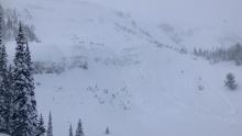
Riding north of Cooke City on 1/29 and 1/30, we observed many natural avalanches that occurred during last week's storm. Avalanches failed within the storm snow or on weak layers in the upper snowpack, on wind-loaded and non-wind-loaded slopes, and on all aspects. We observed avalanches on Crown Butte, Wolverine, Scotch Bonnet, Sheep Mountain, and near the wilderness boundary at Goose Lake.
More Avalanche Details


SS-N-R2-D2-I
Elevation: 9,000
Coordinates: 45.1153, -109.9140
Caught: 0 ; Buried: 0
Several avalanches in the Goose Lake area. Assuming they happened on Friday or Saturday. Photo: J. Mundt (Beartooth Powder Guides)
More Avalanche Details
SS-N-R2-D2-I
Elevation: 9,500
Aspect: W
Coordinates: 45.0202, -109.9380
Caught: 0 ; Buried: 0
From obs. 1/29/23: Some photos of recent natural avalanche activity near Cooke City attached. We observed about 10 slab avalanches today that ran during this cycle.
More Avalanche Details
SS-N-R3-D2.5
Elevation: 9,000
Coordinates: 45.8512, -110.9480
Caught: 0 ; Buried: 0
From obs 1/29/23: "Noticed multiple crowns while driving up to bridger bowl this morning. Most evident was wide crown line on saddle peak below the corniced ridge stretching from the summit towards football field. Another was an obvious crown on what I believe is Argentina Bowl south of Saddle peak. From a distance, this all looked like new snow crowns and didn’t seem like anything stepped down to our buried weak layers. East wind had an interesting effect on the ridgeline above bridger bowl."
BBSP noted on 1/29/23: "A crown on Saddle Peak could be seen in today's bright light. It began at the football field, extended to the top of the peak and a flank was visible extending down the skyline. A secondary pocket pulled on the north facing slope below the Going Home Chute. On the west side St Lawrence pulled out wall to wall, and behind Mountain Mother had a crown that was more filled in on the south facing side that began about half way down. Also, a crown was noted on the south facing ridge of Bradley's Meadows ridge below the cliffs."
From 1/30-2/4 we also noticed old crowns "Between the Peaks" on Saddle, in the Y-couloir on the West side of Saddle Peak and in Jones creek on the west side.
More Avalanche Details
SS-N
Elevation: 9,000
Aspect: SE
Coordinates: 45.0254, -110.0310
Caught: 0 ; Buried: 0
A couple naturals seen on S-SE aspects and a couple whomps. While we were going up. Stuck to low angle fun the rest of the day.
Stay safe this cycle you guys!
More Avalanche Details
SS-AMr-R3-D2
Elevation: 9,500
Aspect: N
Coordinates: 45.1719, -111.3800
Caught: 0 ; Buried: 0
From IG message: "Another one today. Back of buck creek. Triggered 100 yards above where I crossed below it in the safe zone, after I went by. No burials."
More Avalanche Details
SS-N-R2-D2-I
Aspect: E
Coordinates: 44.9739, -109.9240
Caught: 0 ; Buried: 0
Multiple natural avalanches were seen on all aspects, all elevations near Woody Creek Cabin. Poor test scores (ECTP) in 4/6 pits, mostly beneath the snow that fell earlier this week, buried small grain facets and decomposing surface hoar.
More Avalanche Details

Caught: 0 ; Buried: 0
While snowmobiling up Little Bear we witnessed this natural avalanche. There was 2-3' of new snow.
More Avalanche Details
SS-N-R3-D2-I
Elevation: 10,000
Aspect: N
Coordinates: 45.0497, -109.9640
Caught: 0 ; Buried: 0
Natural avalanches, very large below Chimney Rock by Daisy Pass. And north side of Crown Butte observed on 1/28/23
On 1/29/23 GNFAC forecasters saw many more recent avalanches.
More Avalanche Details
SS-N-R3-D2-I
Elevation: 10,000
Aspect: W
Coordinates: 44.9739, -109.9240
Caught: 0 ; Buried: 0
Photo of Castle/Submarine on woody ridge. This all slid today. Looked like all chutes along this face and south slid. Also east facing Republic ridge several slides above rock band. We skied woody west face to 9500 feet. Wind effected snow. Top 2 feet hollow. Not bonded to older snow. 30 degrees. Skied down short of objective
More Avalanche Details
HS-N-R2-D2-O
Elevation: 9,400
Aspect: NE
Coordinates: 45.0659, -111.2820
Caught: 0 ; Buried: 0
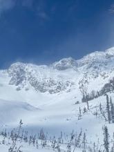
We rode to the Taylor Fork weather station (near Pika Point on the rim of Sunlight Basin) and noticed a few slides along the way. At the weather station we could see that the north end of the basin natural avalanched: the slopes from where the cornices end in Sunlight Basin past Pika Point. It broke up to 2.5 feet deep on an old layer of facets and surface hoar. The slide was R2 D2, 3-400 feet vertical and at least 750 feet wide. It was a large Hard Slab. We spent time at the crown digging, making a movie and getting cold. No surprises, just great to see a real avalanche. We also saw smaller slides looking west from the station, close by. Afterward, we rode to the Sage/Carrot divide in deep snow; hero riding. Skyline Ridge was obscured in clouds.
On the drive back to Bozeman we could see many slides on road cuts and on slopes across the river; low elevation avalanches that we don’t get to see often.
The avalanche recorded in this form is the one in Sunlight Basin that we made the movie about.
More Avalanche Details

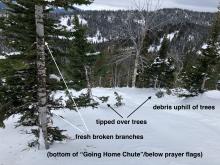
N-R3-D2.5
Elevation: 9,000
Aspect: W
Coordinates: 45.3407, -111.3910
Caught: 0 ; Buried: 0
On 2/4/23 we toured up the ridge between Going Home Chute and Tyler's (below prayer flags). We saw evidence of a large avalanche that broke during the avalanche warning last weekend in Going Home Chute, R3-D2.5 (see photos). It appeared to have run to the end of the runout zone and tipped over small trees.
More Avalanche Details
SS-N-R3-D1.5-O
Elevation: 8,000
Coordinates: 45.2777, -111.4510
Caught: 0 ; Buried: 0
From IG "Natural slide on southwest facing slope along Jack Creek Road in Moonlight Basin"
More Avalanche Details
SS-N-R3-D2-I
Elevation: 10,200
Aspect: NE
Coordinates: 45.2268, -111.5120
Caught: 0 ; Buried: 0
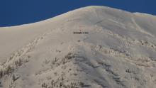
Took a drive up and around the Yellowstone Club and saw this slide today. I think that is Cedar Mt with Pioneer Ridge in front and to the left. Stay safe out there.
More Avalanche Details
N-R3-D2
Elevation: 8,300
Aspect: NE
Coordinates: 45.8301, -110.9340
Caught: 0 ; Buried: 0
I was skinning up the ramp on Friday when I thought I heard a jet flying over in the clouds, but the sound stopped instantly. I assumed that I heard an avalanche, but was solo on the ramp and had no desire to go that way for a better look. It was snowing and foggy. Today a friend said she could see a crown on the north side of Wolverine bowl that appeared to be 4 feet. With all that water, I thought something would go deeper, eh?
More Avalanche Details
SS-N-R3-D2
Elevation: 9,000
Aspect: N
Coordinates: 45.4444, -111.0040
Caught: 0 ; Buried: 0
There were numerous debris piles, point releases, and crowns on the north face of Elephant and the northeast face of Blackmore this morning. Most of them appeared to have run during the storm (1/27) and had been covered by at least 6 inches of new snow.
More Avalanche Details
SS-AM-R2-D1-I
Elevation: 8,000
Aspect: E
Coordinates: 45.1719, -111.3800
Caught: 0 ; Buried: 0
We rode through 1st, 2nd, and 3rd Yellowmule. Measured 13” of new snow with 0.6” SWE in 1st Yellowmule at 10 am. This brought the two day snow total to approximately 20”. Snowed all day with varying intensity and there were strong west winds along the ridge.
Visibility wasn’t great, but we saw most of the avalanche terrain in the Yellowmules. ..... saw a very small snowmobile triggered avalanche on a roadcut on the way out (6-12 inches deep, ~20 ft wide) that broke on facets in the thin snowpack.
More Avalanche Details

SS-ASr-R3-D2-I
Coordinates: 45.9043, -110.9580
Caught: 0 ; Buried: 0
From IG:
More Avalanche Details
SS-N-I
Elevation: 9,000
Aspect: SE
Coordinates: 45.0202, -109.9380
Caught: 0 ; Buried: 0
2-3 feet of new snow was reported above Round Lake in Cooke City. Many natural avalanches were seen on S-SE slopes. From afar they look to be breaking on new-old snow interface.
More Avalanche Details
SS-N-R3-D1.5-I
Elevation: 8,000
Aspect: SE
Coordinates: 45.0202, -109.9380
Caught: 0 ; Buried: 0
Natural avy on SE aspect 8000 ft 35 to 40 degrees. Broke on new snow interface today. YNP next to Silver Falls. Also several slides in gully below falls.
More Avalanche Details
Coordinates: 45.0202, -109.9380
Caught: 0 ; Buried: 0
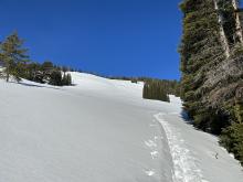
Made it out past round lake around 11am this morning - dug multiple hand pits above 9400' to gauge new snow depth - 40-50 cm new snow from this storm, very light, over the hood riding! Minimal wind below alpine, upper 20cm new snow collapsed easily in hand pits, very little cohesion in the new snow.
Observed several smaller avalanches, all in new snow, undetermined whether natural or ridder triggered, attached photo of the only slide I could get an alright photo of, vis was limited.
More Avalanche Details
SS-AS-R4-D2
Coordinates: 45.5204, -110.9600
Caught: 0 ; Buried: 0
A skier triggered a slide about 20-30 yards wide and 2-4ft thick.
More Avalanche Details

SS-N-R2-D2-I
Elevation: 9,400
Aspect: NE
Coordinates: 45.1719, -111.3800
Caught: 0 ; Buried: 0
On January 28 we rode along Buck Ridge... Visibility wasn’t great, but we saw most of the avalanche terrain in the Yellowmules. Saw one avalanche along the 2nd Yellowmule headwall that broke 100-150 ft wide just under the new snow (maybe 1-2 ft deep, it was hard to tell)....
More Avalanche Details
N
Elevation: 9,001
Aspect: W
Coordinates: 45.4472, -110.9620
Caught: 0 ; Buried: 0
An ice climber across the valley observed a large natural avalanche running over Silken Falls ice climb on the east side of the Main Fork. Wind was blowing and moving snow all day. This gully gets wind-loaded and was the site of a fatal avalanche in 2009.
More Avalanche Details
L
Aspect: E
Coordinates: 45.8301, -110.9340
Caught: 0 ; Buried: 0
Had some cracking, collapsing of wind drifts up high on the ridge today and few DLs running into Wolverine.
Winds were swirling, and coming from the south when I was skiing, but obviously the storm pattern is moving from the north.
Super wind scoured slopes from yesterday not bonding well in other places.
More Avalanche Details
L-AS-R1-D1-I
Coordinates: 45.4272, -111.0140
Caught: 0 ; Buried: 0
From Obs: "Dug on a sheltered N aspect at 9,000 feet below Alex Lowe Peak. Performed an ECT with results of ECTN 12 at 30cm deep and ECTP 21 near the ground.
We also observed widespread sluffing of the new, low-density snow throughout the day and increasing wind transport in the afternoon."
More Avalanche Details
SS-N-R1-D1.5-O
Coordinates: 44.7145, -111.3180
Caught: 0 ; Buried: 0
Observed two recent natural avalanches on 1/25/23 that broke 1-2 feet deep, presumably on a surface hoar layer. There was a couple of inches of snow on each of these slides, so I would place them between three and five days old. The slides were R1-D1.5 in size - 75-100' wide, 1-2' deep, and 100' vertical fall. Photo: GNFAC
More Avalanche Details
L-ASc-R1-D1-I
Coordinates: 45.4574, -111.0000
Caught: 0 ; Buried: 0
Skiers near Mt. Blackmore noted easy-to-trigger loose snow avalanches sliding up to 8" deep.
More Avalanche Details
SS-ASr-R1-D1-I
Elevation: 9,900
Aspect: E
Coordinates: 44.9739, -109.9240
Caught: 0 ; Buried: 0
Beartooth Powder Guides reported remote triggering a small wind slab on the SH layer and a small natural in the lower part of the Bowl that also likely slid on the fresh SH 40’ wide 4” thick. East aspect 9900’.
More Avalanche Details
SS-ASu-R1-D1.5
Elevation: 9,600
Aspect: E
Coordinates: 45.2777, -111.4510
Caught: 0 ; Buried: 0
From Big Sky Ski Patrol 1/21/23: "skier triggered a surface wind slab in Wyoming Bowl that broke 8-12” deep. It propagated to an estimated 150’ wide- SS, R1/D1.5... The slide was small, no one was hurt, and the avalanche was reported (which we appreciate), with no further public involvement other than the trigger."
More Avalanche Details
N-R3-D2
Elevation: 9,500
Aspect: NW
Coordinates: 45.4402, -110.9310
Caught: 0 ; Buried: 0
Bad quality but a D2, R3 natural in Flanders cirque. Looked like it was just the new snow, but hard to say.... on a NW aspect around 9,500 feet
More Avalanche Details
HS-NC-R2-D2-O
Elevation: 10,000
Aspect: E
Coordinates: 45.0423, -109.9650
Caught: 0 ; Buried: 0
Observed this cornice fall triggered slide morning of 1/19/23. It was not there the previous morning which was sunny and clear. Photo: GNFAC
More Avalanche Details

SS-N-R1-D1-I
Elevation: 9,000
Aspect: E
Coordinates: 45.2117, -111.4780
Caught: 0 ; Buried: 0
Natural soft slab release likely in the last 36 hours. Seen from in-bounds at the Yellowstone Club. Avalanche location at 45.2116512 N 111.47811 W at the headwaters of Muddy Creek.
More Avalanche Details
Coordinates: 44.5611, -111.4430
Caught: 0 ; Buried: 0
I dug one pit at 8200’ NE aspect in Yale ECTX. Kevin was a little lower and around on the east side of Sawtell, he felt a big wumph. He didn’t confirm what layer, but this is probably your buried SH.
More Avalanche Details
SS-ASu-R1-D1-S
Coordinates: 45.4494, -111.0760
Caught: 0 ; Buried: 0
Today we toured up Storm Castle Ridge with hopes of skiing the 19th Street Couloir. On the approach we were able to trigger small (2-4") wind slabs on most lee aspects, these slides ran fast and far for their size. We dug a pit at 9200' on a North aspect and we're able to identify the surface hoar but had no results on our ECT. With 2 spotters I dug an ECT 10m below the top of the 19th Street Couloir and got and ECTP12@ 35cm below the surface. The slab was 35cm thick, pencil hardness and failed on faceted snow; the buried surface hoar found in most other pits was not present. We bailed to the opposite side of the ridge and enjoyed some wonderful burn skiing.
More Avalanche Details
SS-AMu-R1-D1-I
Coordinates: 44.6249, -111.2590
Caught: 0 ; Buried: 0
Small avalanche broke while descending to less exposed areas. Approximately 80 yards wide, 18” deep. Slid for approximately 90 yards from crown.
More Avalanche Details
SS-ARu-R1-D2
Elevation: 9,000
Aspect: E
Coordinates: 45.7943, -110.9360
Caught: 0 ; Buried: 0
A snowboarder triggered two shallow avalanches (estimated 4-6 inches deep) on Saddle Peak in the new snow. The slide was as the snowboarder dropped off "Quarter Saddle" and a second pocket propagated above him as he traversed out of the first slide. The snowboarder wasn’t caught and the debris mostly stopped short of the main cliff with a little pile dropping off into the going home chute.
Another slide was seen from the highway in Argentina Bowl. This slide appears to be a shallow soft slab that ~50 ft wide and ran ~500 vertical ft.
More Avalanche Details

Coordinates: 44.7292, -111.3230
Caught: 0 ; Buried: 0
Dave and Doug rode around and saw multiple natural and 1 sledder triggered slide on Lionhead. Some were thin and just involved news snow and others were deeper and broke on the buried surface hoar layer.
More Avalanche Details


Coordinates: 44.9954, -109.9140
Caught: 0 ; Buried: 0
Observed a point release that appeared to have stepped down. This occurred SE of the “rip curl” zone. We also noticed significant sun effect and a warming trend throughout the day. 1/17/23
More Avalanche Details
SS-N
Coordinates: 45.0202, -109.9380
Caught: 0 ; Buried: 0
East aspect, 10,300. Estimated to be about 75' wide. Likely occurred yesterday, Jan. 17th.
More Avalanche Details
SS-N-R1-D1-O
Elevation: 9,300
Aspect: N
Coordinates: 45.0202, -109.9380
Caught: 0 ; Buried: 0
Noted a couple of fresh slab avalanches out there today. Both were on northerly aspects around 9300'. Photo of one attached.
More Avalanche Details
L-N-R1-D1-S
Coordinates: 45.4291, -111.0020
Caught: 0 ; Buried: 0
From obs: "Toured into Alex Lowe basin today and noticed lots of point release slides. Most started as spindrift in the cliff bands along the ridge and gained more snow as they fell into the aprons. Skied a north and south facing couloir, ski cut at the top of both runs and got the new snow to sluff most of the way down. Didn't encounter any cohesive slabs, just lots of sluff sliding down."
More Avalanche Details
SS-N-R1-D2-O
Elevation: 9,600
Aspect: NE
Coordinates: 45.0399, -109.9610
Caught: 0 ; Buried: 0
Dug a pit on the east side of Henderson at the ridgeline above Henderson Bench. ENE, 10,075' elev. ECTP19 x3 on a layer of surface hoar buried 60cm (2 feet) deep. HS 260cm....
There was also a more recent natural avalanche (less than a day old) on Miller Ridge. SS-N-R1-D1.5-O and probably broke on the surface hoar layer.
More Avalanche Details
HS-AMu-R1-D2-O
Elevation: 10,000
Aspect: NE
Coordinates: 45.0524, -109.9450
Caught: 0 ; Buried: 0
Skied on Henderson mountain the afternoon of 1/16. Wind was calm, snowfall was light and steady through the day with 3-4" of new snow.
Dug a pit on the east side of Henderson at the ridgeline above Henderson Bench. ENE, 10,075' elev. ECTP19 x3 on a layer of surface hoar buried 60cm (2 feet) deep. HS 260cm. There was an avalanche a few hundred feet north on an east-northeast facing slope below the ridge. It appeared to be snowbike triggered and 1-2+ days old. 150' wide and 250' vertical. HS-AMu-R2-D2-O. It appeared to have broke about 2' deep on that layer of surface hoar. (There was also a more recent natural avalanche (less than a day old) on Miller Ridge, slightly smaller. SS-N-R1-D1.5-O and probably broke on the surface hoar layer. Separate entry in avy log).
More Avalanche Details

SS-AS-R1-D1.5-O
Elevation: 9,000
Aspect: NW
Coordinates: 44.8256, -111.3110
Caught: 0 ; Buried: 0
From Obs: "Ski cut sent a slide that failed on the known-to-be-reactive buried surface hoar layer . Avalanche broke around 12-14” deep, 100’ wide and ran around 100 yards. It was extremely sensitive.
We had skied a similar angle/aspect slope earlier and didn’t get any reactivity. Occurred around 9000’ on NW slope.~ 32 degrees. We did this 2 times on what we thought to be low angle slopes. ended up skiing down a low angle ridge line. The buried hoar isn’t everywhere but it’s touchy when found."
More Avalanche Details
HS-NC-R2-D2-O
Elevation: 10,000
Aspect: E
Coordinates: 45.0465, -109.9770
Caught: 0 ; Buried: 0
On January 16 observed an old cornice triggered avalanche on Miller Ridge that broke to the ground, appears to be many days or weeks old.
More Avalanche Details
SS-N-R1-D1.5
Aspect: N
Coordinates: 45.0469, -110.0010
Caught: 0 ; Buried: 0
We observed a north-facing natural sluff turn into a reasonable slide release over the cliff bands from the ridge line between Miller and Wolverine today while skinning on the flat bench above the road out to Wolverine Peak today. I think it released right at Sunset peak. It may have started with a cornice release but was more like wind loading on the steep face. We also saw some minor cracking on north facing wind loaded roll overs above the bench. We opted to descend low-angle trees back to our sled and to go ski Henderson.
More Avalanche Details
HS-AS-R1-D1
Coordinates: 45.4382, -110.9900
Caught: 0 ; Buried: 0
Started a small wind slab avalanche on an isolated rollover about 2/3 of the way down the face of elephant mountain yesterday (Thursday January 12th). Broke a few inches deep, about 8 feet wide, and ran less then 100 ft.
More Avalanche Details
SS-ASu-R2-D1
Elevation: 10,000
Aspect: N
Coordinates: 45.4164, -110.9700
Caught: 0 ; Buried: 0
From obs:
While skiing down 'Fat Maid' I triggered a shallow wind slab, after I was about 3/4ths of the way down the couloir. The slide broke to my left as I entered a wider section of the run, that holds a small perched bowl feature (which is what ripped out). The slide didn't propagate out into the main couloir, so the debris never impacted me. Even if it had, I don't think it would've been big enough to knock myself or any other skier off their feet. The slide was about 1/2 the width of the couloir and ran out to about 3/4ths of the apron's length (R2 D1?). The crown was 1-3" deep and maybe 30-40' wide.
More Avalanche Details
AM-D1
Coordinates: 44.8720, -111.3610
Caught: 0 ; Buried: 0
Four small avalanches triggered on SH/NSF.
From obs: "On a few small steeper rollers/micro terrain/logs we released 4 small avalanches on the layer closer to the surface. The biggest slide we triggered was maybe 10-15ft wide and 1ft deep."
More Avalanche Details
AS
Coordinates: 44.8381, -111.3430
Caught: 0 ; Buried: 0
More Avalanche Details

SS-AM-R2-D1.5-O
Coordinates: 44.5658, -111.5000
Caught: 0 ; Buried: 0
From Facebook: High Mountain Adventures snowmobile rental reported one of their renters triggered a slide on the waterfalls (Mt Jefferson/Sawtelle).
More Avalanche Details
SS-N-R1-D1-O
Elevation: 8,100
Aspect: NE
Coordinates: 45.0202, -109.9380
Caught: 0 ; Buried: 0
Photo attached of a fresh natural avalanche, just south of Cooke City today. It appears to have run last night or this morning. (photographed at noon)
More Avalanche Details
SS-N-R1-D1-O
Coordinates: 45.0202, -109.9380
Caught: 0 ; Buried: 0
We saw 2 avalanches that looked to involve new snow. One was on Wolverine on the face and another was on Henderson Ridge under the radio hut. They did not propagate far and wind-loading may have been a factor on the Henderson Ridge slide.
More Avalanche Details
SS-ARu-R1-D1-O
Aspect: E
Coordinates: 45.0003, -109.9540
Caught: 0 ; Buried: 0
Snowboarder triggered this slide on a rollover on East Republic. Reportedly ran 80' wide, 1-1.5' deep. No one was caught.
More Avalanche Details
AMu
Coordinates: 45.0709, -109.9580
Caught: 0 ; Buried: 0
Rider-triggered avalanche reported near Lulu Pass. Limited details. Unknown if anyone was carried or buried.
More Avalanche Details
SS-AM-R1-D1
Aspect: N
Coordinates: 45.1719, -111.3800
Caught: 0 ; Buried: 0
A rider triggered a small slide in First Yellowmule on Sunday. Broke 6 -8" deep, 60' wide, and ran 20'. North face, about 37 degrees steepness.
More Avalanche Details
HS-AR-R2-D1.5-O
Aspect: W
Coordinates: 45.2777, -111.4510
Caught: 0 ; Buried: 0
From email: "Remote triggered avalanche yesterday on west facing slope of lone mountain backcountry. Observed wind loaded Slope, shooting cracks then woomph, followed by a collapsing snow pack 20 feet ahead. Crown approximately 1.5 feet tall 15-20 feet wide."
More Avalanche Details
AMu
Coordinates: 45.0524, -109.9450
Caught: 0 ; Buried: 0
A rider-triggered avalanche was reported from a slope near Chimney Rock on the north end of Henderson Mountain. Limited details. Unknown whether anyone was caught or buried.
More Avalanche Details
HS-ASu-R2-D1.5-I
Elevation: 9,800
Aspect: E
Coordinates: 45.0344, -109.9840
Caught: 1 ; Buried: 0
Skier unintentionally triggered and was caught in wind slab avalanche on the Y couloir in Sheep Creek Drainage. Skier was carried 10m before self arresting. The slide ran ~250m down and broke across the entire width of the couloir. There were no injuries and skied away.
More Avalanche Details
SS-ARu-R2-D1.5-I
Elevation: 9,200
Aspect: NE
Coordinates: 45.1719, -111.3800
Caught: 1 ; Buried: 1
Location: 45.165, -111.35808 (onX)
Elevation: ~9,200 feet
While riding a small NNE facing slope near the trail on Buck Ridge, a snowboarder triggered and followed a cornice slide that propagated approximately 75 feet and slid about 20' vertical. The one rider was caught and carried approx. 10' and ended up buried upright, waist deep with no injuries.
More Avalanche Details
HS-N-R2-D2-O
Elevation: 9,000
Aspect: NE
Coordinates: 45.9043, -110.9580
Caught: 0 ; Buried: 0
From IG 1/7/23: "Natural slide in avalanche bowl up in fairy lake today."
More Avalanche Details
SS-AS-R0-D1-I
Elevation: 7,000
Aspect: S
Coordinates: 45.8822, -110.9520
Caught: 0 ; Buried: 0
While skiing back to our sleds we triggered a very small slide on a small, ~35º below treeline slope (SS-ASu-R1-D0.5). This was on a southerly aspect, at about 7,000 feet, 4-6” down on surface hoar, 15’ wide, 30’ vertical run. There was a very hard crust underneath the surface hoar.
More Avalanche Details
N-R2-D2.5-O
Elevation: 9,000
Aspect: E
Coordinates: 45.7943, -110.9360
Caught: 1 ; Buried: 1
At 1:30 PM on Jan 6th a large avalanche poured over the cliffs on Saddle Peak, outside the boundaries of Bridger Bowl. Clouds obscured the starting zone. Multiple groups were in the runout zone, including a skier hitting a jump. One person was caught and buried up to his neck. He was able extricate himself and was unharmed. He did a beacon search at the toe of the debris. He estimated the debris was at least six feet deep.
We believe this was a natural avalanche that broke in the new and wind drifted snow which then broke into older snow. Bridger Bowl measured 6" of new snow with 0.75 inches of Snow Water Equivalent at the Alpine Wx. Station. The avalanche was estimated to be 2 feet deep, and measured on Google Earth to be 550 feet wide and 1700 feet long.
More Avalanche Details


SS-ASc-R2-D1-I
Elevation: 8,900
Aspect: E
Coordinates: 45.0202, -109.9380
Caught: 0 ; Buried: 0
Recent low density snow was drifted into 10” soft slab from west wind, north of Cooke City. Skier triggered intentional on test slope.
More Avalanche Details
Aspect: S
Coordinates: 44.5597, -111.7160
Caught: 0 ; Buried: 0
Had seven sleds in a relatively small area on the south-facing side of Taylor mountain at about 10k ft.
Group noticed a substantial whumph after sitting for less than a minute.
More Avalanche Details
L-N
Coordinates: 45.4468, -110.9360
Caught: 0 ; Buried: 0
At about 10 AM I was belaying my partner on the first pitch of Bobo Like in the Flanders drainage of Hyalite Canyon. We heard a low rumble and a couple seconds later we were engulfed in snow that poured out of the the pitch 2 gully, and seemed to keep coming for about 5 seconds. My partner, who was on lead, was lucky enough to be at the base of the vertical ice of p1, so the snow mostly went over his head. I was off to the side and close to rock at the base and was engulfed in loose snow, but not buried or injured. We continued up afterwards. When I was at the top of the second pitch, belaying my partner up, another small loose snow avalanche came down as river of snow, passing me as I hugged the anchor, and washed over my partner while he was on the pitch. We were fortunate to have both been in positions to handle these avalanches without incident or injury. In retrospect, the clear day and blasting morning sun likely loosened the snow above the gully and funneled it all down onto us. After the first avalanche, the sun must have kept moving onto new slopes above, releasing more snow. Even with a moderate danger level in the avalanche report for the day, with natural avalanches unlikely, we happened to find ourselves in a very specific scenario, with morning sun and a dangerous terrain feature, that still put us at risk. Hopefully we will use this experience to improve our assessment of risk, terrain, and evolving conditions in the future.
More Avalanche Details

AMu-R3-D2-O
Aspect: E
Coordinates: 44.9277, -111.2430
Caught: 0 ; Buried: 0
From FB message: “Near Sage Creek/Sage Mountain in carrot basin. This was a east facing, wind loaded slope. Snowmobile triggered below the rock line. No burials.”
More Avalanche Details
R1-D1
Coordinates: 44.8949, -111.2280
Caught: 0 ; Buried: 0
Two natural avalanches in the Cabin Creek area.
From instagram: "Right off the trail at tepee creek just before the cabin. A natural slide about 2ft crown"
From email: "I came across this older avalanche yesterday when I was guiding a group in the Kirkwood area, it’s an area in the Cabin Creek drainage. It looked to be an older natural slide probably just after the last storm cycle a few days to almost a week ago now. North, North East Aspect. Approximately 39 degree slope (Because of a creek with open water just below the slide, I couldn’t get close enough to accurately measure the slope)".
More Avalanche Details

SS-AM-R1-D1
Elevation: 9,400
Aspect: NE
Coordinates: 45.1719, -111.3800
Caught: 0 ; Buried: 0
Small snowmobile triggered slide (~1ft deep and ~20x20 ft) at the head of Muddy Creek (NE Aspect, 9400 ft) off Buck Ridge. Looks like it was likely triggered on Sunday (Jan 1st) in a shallow spot near rocks.
More Avalanche Details
SS-N-R1-D2-S
Elevation: 9,000
Aspect: NE
Coordinates: 45.7943, -110.9360
Caught: 0 ; Buried: 0
From BBSP: "The recent storm snow in the bowl south of Quarter Saddle avalanched overnight, from what appeared to be a cornice drop. The debris stopped shy of the second cliff band."
More Avalanche Details
SS-N-R2-D1.5-I
Elevation: 8,800
Aspect: E
Coordinates: 44.7145, -111.3180
Caught: 0 ; Buried: 0
Riding below Lionhead Ridge on 1/2, we observed several relatively small slab avalanches that failed below the weekend's snow. As well as several loose snow avalanches in steep terrain.
More Avalanche Details

SS-ARu-D1.5-I
Elevation: 9,000
Aspect: SE
Coordinates: 45.0822, -109.8950
Caught: 1 ; Buried: 0
From obs: "A small, snowboarder-triggered avalanche from 12/31 on a southeast-facing slope at 9,000 feet broke on the 30cm layer and stepped down to the 40cm layer. The snowboarder was briefly caught in the sliding snow but maintained his footing as the snow washed past him."
More Avalanche Details
Coordinates: 45.0344, -109.9840
Caught: 0 ; Buried: 0
skied both NE, S and SW aspect lines in Sheep Creek Basin. No signs of wind loading where we traveled, up to 9600’ at the saddle between Sunset and Miller Mountain. There were light winds (M gusts). 8-10” of new low density snow.
Dug a pit on a SW aspect, 8480’:
160cm deep
CT22Q2 Down 40, EctN 25 down 40
ECTP28 down 85
Pole probing confirmed the presence of the top persistent grain layer throughout the landscape, although the associated crust was not widespread.
We also experienced a Whumpf at 45.03667, -109.96733 On a SW slope, 9000’ in a shallow area (125cm depth).
More Avalanche Details
HS-AMu-R2-D2.5-O
Elevation: 8,800
Aspect: E
Coordinates: 44.7145, -111.3180
Caught: 0 ; Buried: 0
On the way back to Lionshead. Came upon this recent avalanche. Rushed up to the group of 4 guys. They were fine, not the guys who set it off. The group of 6 we passed going there set it off. The group of 4 said they saw these guys ... all on the hill at same time, stuck and climbing around the stuck guy. All were okay but I hear one guy was shaken up. 4-5ft deep at break by 200-300ft wide, ran 400+ft.
More Avalanche Details
HS-AMu-R4-D3-O
Elevation: 9,800
Aspect: SE
Coordinates: 45.0525, -109.9620
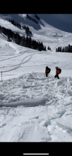
Caught: 1 ; Buried: 1; Killed: 1
On December 31, 2022 a snowmobiler was killed in a very large avalanche north of Cooke City, MT. The avalanche occurred near Daisy Pass on Crown Butte on a southeast facing slope at 9,800’. Two brothers (age 17 and 21) from Washington were snowmobiling uphill on adjacent slopes. The older brother was climbing a steeper slope and triggered the avalanche 100-200’ below the top. He was carried 600 vertical feet and buried 5 feet deep. The buried rider was wearing an airbag pack that was not deployed. Both riders had shovels and probes. They were not wearing avalanche beacons. A nearby group of riders rode up to the slide within minutes after it happened, saw a buried snowmobile and began to search for the rider. One rider from that group went into Cooke City to alert Search and Rescue. The buried rider was located with a probe line an hour after the avalanche happened. He was unable to be revived with CPR and AED at the site. The avalanche appeared to be 2-4' deep, 500' wide, 600' vertical, and broke on weak snow near the bottom of the snowpack. AMu-HS-R3/4-D3-O
Our deepest condolences go out to the family, friends, and those involved.
Full report available here: http://www.mtavalanche.com/accident/22/12/31
More Avalanche Details

HS-AMu-R3-D2-O
Elevation: 10,000
Aspect: W
Coordinates: 45.0722, -109.9280
Caught: 0 ; Buried: 0
...we rode over the saddle between Sheep and Scotch Bonnet and saw an avalanche that appeared very recent, and likely triggered by a snowmobiler. It was on a west facing slope at 10,000', and was a hard slab 1-4 feet deep and 150' wide, ran about 200' vertical. AMu-HS-R3-D2-O. This was a clear sign that weak layers exist, especially where the snowpack is relatively shallower, and recent snow has been drifted into thick slabs that are unstable over this weak snow.
More Avalanche Details


Elevation: 9,000
Coordinates: 44.9592, -111.3130
Caught: 0 ; Buried: 0
From observation: "Snow above collapsed into the trench from my sled, looked to have broken on a weak layer about 1.5’ down."
More Avalanche Details
L-N-R1-D1-I
Elevation: 9,500
Aspect: E
Coordinates: 45.4444, -111.0040
Caught: 0 ; Buried: 0
From observation: "Toured up to the east face of Mt. Blackmore today. We observed two small natural loose dry avalanches occurring right around noon on the new/old snow interface at about 9700' on the E aspect. The largest one ran about 200 feet down into the bowl.
We observed a hollow snowpack on our ascent and dug a pit at 9600' just below the northeast ridge. We found several weak layers that were fracturing beneath two well-defined crusts. We got a CT2 @ 135cm, CT11 @ 130cm, CT13 @ 118cm, and CT15 @ 115cm; in our extended column test we got ECTP15 Q2 @ 130cm."
More Avalanche Details
Coordinates: 46.0395, -113.7920
Caught: 0 ; Buried: 0
Snowmobile club members texted me that they triggered a 3' deep slab, that ran 100 yds., from connected terrain in Frog Pond Basin. It sounded like a heavily wind loaded slope.
More Avalanche Details
N
Coordinates: 46.3237, -113.1020
Caught: 0 ; Buried: 0
Natural avalanche from the top of the popular snowmobile climbing spots on McDermott Hill in the Flint Range near Philipsburg. There have been several close calls and a fatality in this same path. It is named for the person who was killed in an avalanche there in the 70s. It appeared to be a wind load on the ridge that initiated the slide. In the background of a janky video, it appears there were other naturals as well. The slide ran an estimated 800 ft, but no other information was obtained.
More Avalanche Details