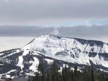
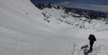
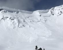
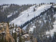
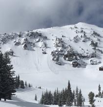
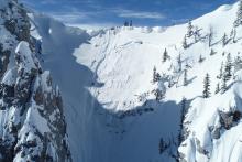
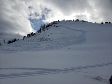
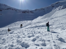
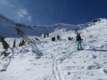
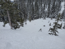
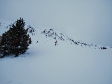
All Avalanche Incidents for Advisory Year 2019-20
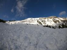
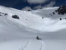
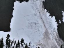
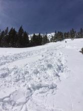
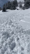
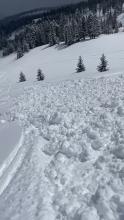
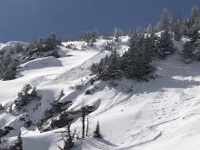
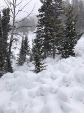
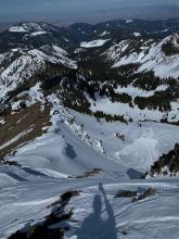
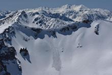
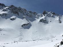
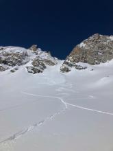
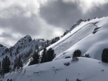
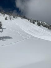
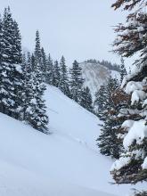
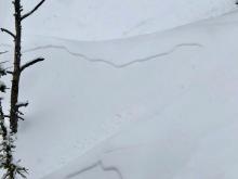
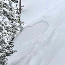
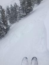
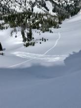
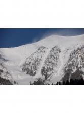
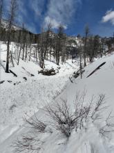
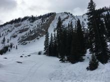
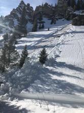
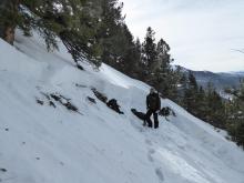
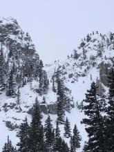
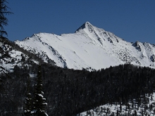
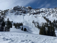
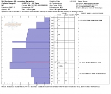
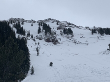
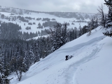
WL-ASu-R1-D1.5
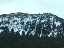
Elevation: 9,000
Aspect: NE
Coordinates: 45.9043, -110.9580
Caught: 0 ; Buried: 0
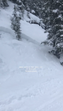
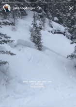
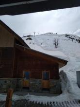
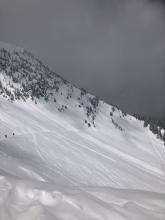
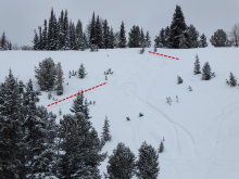
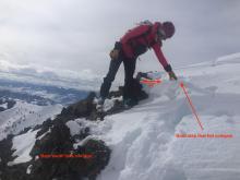
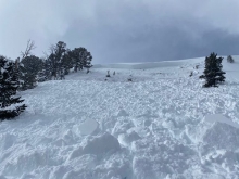
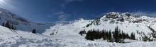
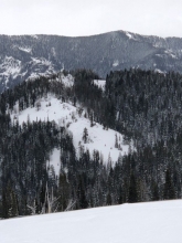
From IG message on June 11, 2020: "...Just wanted to let you know, I was up by fairy lake this morning, and the new snow we got earlier this week was very much still a hazard. Skinning up the fairy lake basin was deceptive, because most of the new snow had melted out there and it was just refrozen corn, but most of the S and E aspects of that area slid naturally on the new snow. I also triggered a small point release on a NE solar aspect that ended up entraining a large amount of snow as it went and was again surprising because both my partner and I had felt quite safe on the snow we’d been on throughout our approach. It certainly caught us off guard and we got out of there safely, but was just a good reminder to not get complacent."
More Avalanche Details
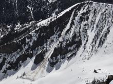
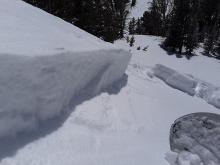
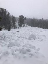
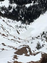
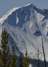
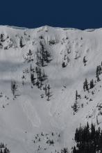
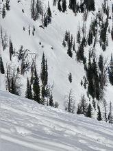
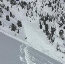
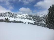
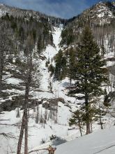
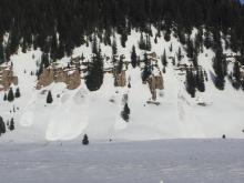
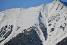
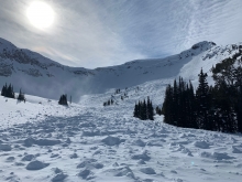
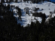
WS-NC-R4-D3.5-O
Elevation: 9,840
Aspect: NE
Coordinates: 45.2311, -111.4410
Caught: 0 ; Buried: 0
Doug McCabe left a message:
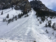
A very large wet slab avalanche released on an east aspect of the YC. It was not human triggered. This is the biggest slide he has seen on the shoulder with an estimated 6-8' deep crown. The slide hit a tower. R4/D3.5.
From e- mail (5/20): "Got a better look today. WS-NC-R4.5-D3.5. Trigger looked to be from a cornice fall. The crown was measured at 1800’ in length and ran full path, 950’. NE facing slope at 9840’. The crown was mostly between 6-8’, but ranged from 4’ to 9’. The cornice fall occurred on a shallower section of the snowpack."
More Avalanche Details

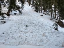
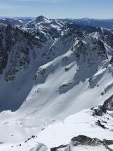
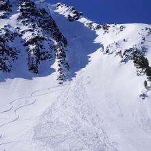
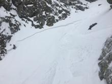
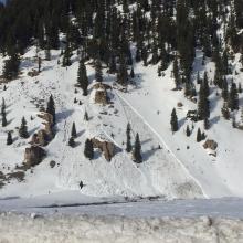
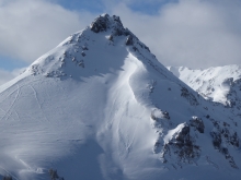
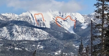
WS-ASu-R3-D2-I
Elevation: 10,000
Aspect: SE
Coordinates: 45.3428, -111.3860
Caught: 0 ; Buried: 0
From (5/17/20): "...WS - ASu - R3 - D2 - I SE face of Middle Basin Peak starting at 10,000' Estimated SZ of 30° Slab depth of about 8". We were out too late in the day and chose to ignore a number of observational warnings. We were lucky and remotely triggered the avalanche below us."
More Avalanche Details
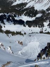
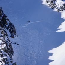
WS-N-R2-D2.5-O
Elevation: 9,000
Coordinates: 45.2630, -110.7070
Caught: 0 ; Buried: 0
From obs: "Here are a few snaps from yesterday (5/2/20), looking into the Absaroka from up on Emigrant. Fair bit of smaller, pockety wet slab activity in steep, rocky terrain near the middle/upper transition. I didn't see anything larger than D2 or any activity in true upper elevation terrain."
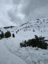
From obs (5/3/20): "N facing gulley, probably similar results from the Pine Creek avalanche posted on 4/29. Avalanche appears to be natural and possibly a couple days old. Ran about 400’ wide in the cone and damned up the creek with massive cement-like debris. There were more similar avalanches on N facing aspects the more I traveled. The skinning was isothermic and sloppy as each step fell through the snowpack to the ground."
More Avalanche Details
WL-N-R2-D2-U
Elevation: 7,500
Aspect: E
Coordinates: 45.8232, -110.9240
Caught: 0 ; Buried: 0
From obs (5/2/20): "LW-U-D2-R2-O Multiple LW avalanche debris fields seen below Bridger Gully (IVO 3 Bears Traverse)"
More Avalanche Details
WS-N-R2-D2-O
Elevation: 9,000
Coordinates: 45.0202, -109.9380
Caught: 0 ; Buried: 0
From obs. (5/2/20): "Some recent wet slab avalanches were observed around Cooke City yesterday. North and south aspects to mid elevations... not sure of the exact timing, but attached is a photo of one, a southerly aspect around 9,000'."
More Avalanche Details
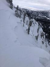
WS-N-R2-D2
Elevation: 8,700
Aspect: W
Coordinates: 45.3375, -111.3870
Caught: 0 ; Buried: 0
From obs (5/2/20): "Wet slab avalanche possibly triggered by wet loose/ point release from above in the cliffs. Adjacent to “The Gem”. The crown looked to be about 2-2.5’ deep." Photo: N. Sheil
More Avalanche Details
WS-N-R4-D3.5
Elevation: 9,200
Coordinates: 45.4900, -110.4950
Caught: 0 ; Buried: 0
From e-mail (5/1/20): "...the mountains are coming unglued with the 4 nights of no freeze and heavy rain. My party ventured up pine creek to take a look and found this big one that ran either yesterday or last night."
More Avalanche Details
Elevation: 8,000
Aspect: NE
Coordinates: 45.5930, -110.4120
Caught: 0 ; Buried: 0
From obs (4/26/20): "....a wet slide from a n-ne couloir up mission creek near elephant head in the absarokas between 10-11:30 this morning. Snow did not freeze over last night and was heavily saturated early this morning before the sun rose." Photo: @laura_delray
More Avalanche Details
WL-N-R2-D2
Elevation: 7,500
Coordinates: 45.8512, -110.9480
Caught: 0 ; Buried: 0
Skiers observed large wet loose avalanches at Bridger on 4/22
GNFAC forecaster noted many natural wet slides throughout the Bridger Range. D1-D2 in size on E-S aspects from previous days (4/20-4/22). One slide north of Flathead Pass appeared to gouge to the ground and may have been a narrow wet slab. All others were relatively shallow, but some ran far.
Glide cracks opening on the Throne and Glide Plane.
More Avalanche Details
WL-N-R1-D1
Coordinates: 45.3504, -111.3870
Caught: 0 ; Buried: 0
From obs (4/22/2020): "Early this morning we ascended near peak 10467 between Beehive and Bear Basin and skied a line off the south-east ridge. We noticed an old wet slide (a day or so) at the exit of the couloir we skied, and many more slides, point releases and large pinwheels off of south-east aspects of peak 10467 and on the saddle between peak 10467 and 10390. These all appeared to be from yesterday or the day before yesterday. On the north-east aspects there was an approximately 6" wind crust on top of a relatively isothermic upper layer (did not dig deep enough to see if it was isothermic throughout) that started melting rapidly once the sun hit it."
More Avalanche Details
WL-N-R2-D1.5-I
Elevation: 9,000
Coordinates: 45.9233, -110.9800
Caught: 0 ; Buried: 0
In Frazier, all surfaces except the upper north faces were getting wet and sticky. We observed lots of wet loose avalanches actively happening on SE-E facing slopes. There was one small crown on a steep East facing slope that looked to be from the most recent storm but everything else was loose wet. Small wind slabs from the last snow seemed to be glued down today.
More Avalanche Details
WL-N-R2-D2-I
Elevation: 9,000
Coordinates: 45.3374, -111.3810
Caught: 0 ; Buried: 0
Saw quite a few natural wet slides back in Middle Basin over the past two days, April 17-18. Witnessed several break loose naturally after about 2pm on anything from SW to SE slopes
More Avalanche Details
SS-NC-R1-D1.5-I
Elevation: 8,400
Coordinates: 45.8156, -110.9230
Caught: 0 ; Buried: 0
GNFAC forecaster observed many wet loose slides entraining recent snow from Bridger Peak through the Throne. There were also fresh drifts along the ridgeline that broke naturally and became long running wet loose slides. Slide sizes ranged D1-D2.
From obs email (4/17/20): "5(?) slides into North Bowl (the two large ones already on your site plus 3 smaller ones - 2 of which happened sometime during the morning (they were not there when I left the car at 745). Also new slide in Bridger Gully. Plumes of snow blowing off the ridge / Saddle Peak"
More Avalanche Details
WS-ASu-R1-D1-I
Elevation: 7,500
Aspect: SE
Coordinates: 45.8411, -110.9390
Caught: 0 ; Buried: 0
Obs (4/17/20): "Today while skiing at the Playground in the Bridgers my party triggered a wet slab on an ESE 33 degree slope at 7,700' (HS-ASu-R1-D1-I). No one was caught or injured. We decided to turn around as the sun was roasting the snow at 11:45 a.m., and picked a low angle slope to ski back to the trail. Skier 2 descended and popped out a slab about 10" thick and 50' wide, but the slide was slow moving at first and he was able to ski away. The slide gained momentum pretty quickly and ran powerfully about 250' down the slope."
More Avalanche Details
L-AS-R1-D1.5
Elevation: 8,000
Coordinates: 45.8156, -110.9230
Caught: 0 ; Buried: 0
Skiers reported many loose snow avalanches after noon.
"Small slide off of banzai into a chute fan. Natural release. Pic before slide 12:43 of slide 12:51"
"[In north bowl] Around one o’clock. Right before the two skiers skinned by."
More Avalanche Details
SS-AS-R2-D1.5-S
Coordinates: 45.8156, -110.9230
Caught: 0 ; Buried: 0
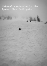
From IG "Natural avalanche in the Apron. Ran Full path"
From Email, "We just did one run down Ptarmigan. Winds were cranking out of the north from about Midway Bridger on higher. Over on the north side of Bronco, there were some wind drifts that were super sensitive and were cracking and sliding into the skin track easily. While skiing the snow felt pretty upside down, similar to what we were seeing on the skin track. Did a ski cut as I came up to that first rollover that is often rocky early season and triggered a small avalanche. It cracked easily and slid, but with the fairly gentle slope angles right below that rollover it stopped pretty quickly. We only did that one run and with the snow as sensitive as it was I wouldn’t have wanted to go up to the ridge today."
Observed debris from 3 new snow avalanches from the top of Powder Park Lift at Bridger Bowl. Two ran from the Dick's/ Bradley's Rib area across the North Bowl Road and well into North Bowl. One slide on the south edge of Baby Bear came through the trees and stopped 100' above Powder Park Lift.
More Avalanche Details
SS-ASu-R1-D1.5-O
Coordinates: 45.8156, -110.9230
Caught: 0 ; Buried: 0
From obs on 4/14: "Saw an unintentional ski cut at tower 11 on slushmans lift go 16 inches deep and ran down past tower 3 on lift line today. We had 8 inches from sat/sun and another 8 during the day today."
More Avalanche Details
SS-AS-R1-D1-S
Elevation: 7,500
Aspect: N
Coordinates: 45.5097, -111.0820
Caught: 0 ; Buried: 0
From obs (4/12/20: "While on a tour today up Wheeler, I was able to release a small dry loose slide on a N. aspect at 7500 feet. The slide was about 8 inches deep and only ran for 100 feet."
More Avalanche Details
L-N-R1-D1
Elevation: 8,000
Aspect: E
Coordinates: 45.8586, -110.9560
Caught: 0 ; Buried: 0
From obs (4/12/20): "Toured in the middle bridgers today... There was 6-8" of new snow on top of a supportable crust on all aspects. We got some shooting cracks skinning up Texas that propagated about 10-15' wide and 6-8" deep. Also saw some natural dry loose slides on steep terrain near the ridge and up high on Ross. Lots of skier traffic in the area, with some dry loose slides, but nothing bigger than D1.
The best sight-seeing was on the main slide path on the east face of Ross. We saw 4 or 5 old growth trees in the middle of the path that had branches broken off up to 30' high, and a handful of 8" diameter trees that had been ripped out of the ground and deposited at the bottom of the path. Looked like this carnage was from this season; maybe the big cycle mid-feb? Did Ross slide big this year? I saw some pics from the Throne on the website, but nothing on Ross."
Two other groups found similar conditions at Bridger Bowl.
"Went for a short tour up Slushmans today. Light boot top powder had been blown into soft windslabs in odd locations on the upper third of the mountain. Observed some small loose dry slides in steep terrain. The snow down low was getting a little wet but the cold air seemed to be keeping it cool enough to prevent wet avalanches."
"We noted a [small] avalanche that had been (likely) human triggered just north of 3/4 Rock on A-Route. The slide ran almost all the way to the cat road in the bowl. I found variable conditions on the ridge, from about 4 inches of light density snow, to wind slab up 3ft. thick and punchy."
More Avalanche Details
HS-AS-R2-D1.5-O
Elevation: 9,500
Coordinates: 45.3407, -111.3910
Caught: 0 ; Buried: 0
Fresh wind slabs were triggered around a foot thick in Beehive Basin on Sunday 4/12/20.
More Avalanche Details
WL-N-R3-D2.5
Elevation: 9,200
Aspect: SE
Coordinates: 45.3407, -111.3910
Caught: 0 ; Buried: 0
From obs (4/12/20): "Noticed this slide yesterday evening on the way out of Beehive Basin, on the southeast facing aspect. It appeared to have come all the way down from the upper portion of the ridge on steeper slopes. We figured it slid sometime Thursday or Friday in the high temps. There were several other debris paths, but this was the biggest by far."
From obs (4/18/20): "This slide appeared to have happened a few days prior to when we observed it on the 16th. When we skied the skiable terrain at Dudley Creek the snowpack was stable, though snow coverage was thin."
More Avalanche Details
WL-N
Elevation: 9,500
Coordinates: 44.8720, -111.3610
Caught: 0 ; Buried: 0
Skiers in Beaver Creek in southern Madison Range on 4/12/20 reported: "...There were probably a couple dozen [wet slides] in total, including several small ones that ran into Beaver Creek road. Every solar aspect had multiple slides from the past few days of warm weather, at elevations from the road up to 10000', but none were larger than any my partner and I observed near Lionhead on 4/9 (≤D2)." Photo: S. Reinsel
More Avalanche Details
C-NC-R2-D2-O
Elevation: 10,000
Aspect: N
Coordinates: 45.4444, -111.0040
Caught: 0 ; Buried: 0
From IG message (4/10/20): "Huge cornice release on north face of Blackmore today around 11am. North face was not hot yet but I am guessing the rocks on the back side transferred the heat?"
More Avalanche Details
WL-N-R2-D2
Elevation: 8,300
Aspect: SE
Coordinates: 45.8156, -110.9230
Caught: 0 ; Buried: 0
Wet loose slides observed running far into South Bowl morning of 4/10/20. Also slides reported crossing North Bowl road, and far down Slushman's Ravine.
More Avalanche Details
WL-N
Elevation: 9,000
Aspect: SE
Coordinates: 45.1582, -111.4770
Caught: 0 ; Buried: 0
From IG message (4/10/20): "My party and I observed a wet slide off of the s-se facing aspect of the Sphinx today around 1pm."
More Avalanche Details
WS-N-R2-D2
Coordinates: 44.7145, -111.3180
Caught: 0 ; Buried: 0
Skiers in the Lionhead area saw 3 fresh wet slab avalanches on 4/9/2020. One appears to have been triggered by a snowmobile, one by a falling cornice, and the third may have been triggered a wet loose avalanche from above or water running off rocks near the crown.
More Avalanche Details
WS-N-R2-D2
Elevation: 10,000
Aspect: NE
Coordinates: 45.2981, -111.5240
Caught: 0 ; Buried: 0
More Avalanche Details
WS-AM-R3-D2-O
Aspect: NE
Coordinates: 44.7184, -111.3190
Caught: 0 ; Buried: 0
From email: "On Tuesday, April 7th my group noticed a slab avalanche above our route back to the parking lot. The coordinates of the slide are 44.7184217, -111.3190452. There were snowmobile tracks directly to the right (NW) of the slide. The slide was considerably wide , more than100 yards."
More Avalanche Details
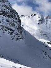
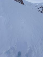
HS-N-R2-D2-O
Elevation: 10,200
Aspect: N
Coordinates: 45.3539, -111.4050
Caught: 0 ; Buried: 0
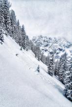
From obs (4/8/20): "My partner and I noticed this slide as we summited 10602 at approximately 10:30am, which is when I took the first photo and was able to capture the full runout. After our descent of the peak, we skinned back up to the slide to get a better look (the second photo). The slide appeared approximately a day old, with a crown 1-2 feet deep, on an almost directly north-facing aspect at 10200" elevation. It broke right along the rocks that had heated up in the sun, and was around 200-300 feet at its widest. We did not get close enough to determine which layer failed (suspected wind from the heavy wind-crust in the neighboring area), but the debris at the bottom indicated it was a wet slide."
More Avalanche Details
L-N-R1-D1-S
Elevation: 9,000
Aspect: SE
Coordinates: 44.9855, -109.9410
Caught: 0 ; Buried: 0
From obs. 4/6/20: "I got tagged by a small point release today. Skinning up the Republic Mountain ridgeline I had stopped to pull skins because it was apparent from hand-pit that the new snow was not bonding well with the old snow interface. I was looking down slope so didn’t actually see the release, but think it was a natural point release that I just happened to be standing in the way of, at least I didn’t feel any collapse so it didn’t seem like I had remotely triggered it.
Restricted to new snow ~ 6” deep and ran for about 80 vertical feet. Point release in rock band at ~8,980 to toe at where I was standing at 8,900’ on ESE aspect on ~35° slope ( 45.004, -109.942).
Wx: Overcast, warm (35°+), calm, snowing heavy at time (0.6 SWE at Fisher Creek SNOTEL in 10 hr.)."
More Avalanche Details
Elevation: 9,000
Aspect: NE
Coordinates: 45.6553, -110.5580
Caught: 0 ; Buried: 0
From obs 4/5/20: "...saw a ton of tracks and a lot of natural dry loose activity. D1-D1.5 slides on steep E to NE terrain between 8000 and 9500'. Everything pictured released between 1200 and 1400 when the sun was out. Looked like rollerballs were heating up on the cliffs and triggering dry loose slides below."
More Avalanche Details
SS-NC-R2-D1.5-I
Elevation: 8,600
Aspect: E
Coordinates: 45.8156, -110.9230
Caught: 0 ; Buried: 0
More Avalanche Details
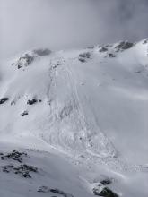
HS-ASu-R1-D1.5-O
Elevation: 10,500
Aspect: S
Coordinates: 45.3539, -111.4050
Caught: 0 ; Buried: 0
From obs 4/4/20: "Avalanche, 4th of July Couloir, Beehive. No person was caught. A dog was caught but not buried. Crown between 2 and 5 inches, based on cracking depth during ascent and pictures. Runout aproximately 120x40 yards. Estimated using gaia gps.
Myself, a partner, and my dog left the busy Beehive parking lot at approximately 0945 this morning (04/04). We noted no instabilities on the approach other than a small debris field under a cornice on the east facing aspect of the ridge to the southwest of Beehive peak. Given the lack of a cornice on our intended route, and the small size of the noted avalanche, we decided to dig a pit and make our decision based on those results.
We dug our pit at the base of the bowl, right under the peak, and had no result. On our ascent, we noted some cracking, which would break on a depth of between 2 and 5 inches. We decided that we would continue, unless the cracking started breaking significantly deeper, based on the relatively light snow and mellow run out. In hindsight, this was a poor decision, especially given the dog with us. Once we got up, we briefly considered skiing the northern aspect, but decided against it based on evidence of wind grooming and the constriction on that side.
The first half of our descent was smooth, although the skiing was somewhat punchy, evidence of wind affected snow. Right after the narrowest part of the couloir I felt the snow under me start to move, but I was able to ski to the right, out of the path. Although the dog was caught, she was fortunately not buried and sustained no injuries. My partner was above me, not in line of sight, and did not know the slide had occurred until he skied down to me. The slide was witnessed by at least two other parties in Beehive."
More Avalanche Details
SS-AMu-R2-D2-O
Coordinates: 45.2890, -111.1410
Caught: 0 ; Buried: 0
From obs. 4/4/20: "Avalanche today up portal creek. 2 1/2 ft crown and 4 - 5 ft runout. Triggered by snowmobile. Everyone was safe!"
More Avalanche Details
Coordinates: 45.8586, -110.9560
Caught: 0 ; Buried: 0
From obs: "Approached a lower angle east facing test slope around 8000 with similar aspect to ski objective. As I stepped out of my skis to dig a pit, we heard a large collapse. Slope we were on was not steep enough to slide but we had our answer. Moved off that slope, dug a quick hasty pit CT12, 1.5 ft down on facets below ice crust, clean shear. Skied down an alternate conservative way."
More Avalanche Details
Caught: 0 ; Buried: 0
From email (4/4/20): "...east aspect, around 9700'. The crown looked to average about 2' deep, and it was about 400' wide. I'd estimate that this avalanche happened on April 1 or 2. (2-3 days ago)".
More Avalanche Details
SS-AS-R1-D1.5
Coordinates: 45.8156, -110.9230
Caught: 0 ; Buried: 0
Skiers triggered slides in the new snow on Saddle Peak, near Peter's point (just north of Bridger Bowl) and on a north aspect just north of Bradley's meadow. 4/2/2020
Description of Saddle Peak Avalanche:
1-2' deep storm slab released on the Main Face of North Saddle about 100' from the ridge. The skier triggered the slide just uphill of the first cliff band. The avalanche propagated 200' wide and ran over the cliffs to the bottom of Going Home Chute. The skier then climbed out and descended a different route.
More Avalanche Details
SS-N-R1-D1.5
Elevation: 9,700
Aspect: N
Coordinates: 45.0202, -109.9380
Caught: 0 ; Buried: 0
From email on 4/2/2020 "fresh, natural slab avalanche this morning. Estimated to be about 50' wide. A north facing aspect around 9700'. It looks to have been triggered by a sluff that came off the steep rocky terrain above."
More Avalanche Details
SS-N-R2-D2-I
Aspect: E
Coordinates: 45.7943, -110.9360
Caught: 0 ; Buried: 0
The clouds parted briefly around noon today and we got a view of north saddle. Pretty good size crown running up a ridge line from the cliffs to about 150’ short of main ridge, likely failed at the new snow/old snow interface. R2D2.
More Avalanche Details
L-ASc-R0-D1
Elevation: 7,450
Aspect: NE
Coordinates: 45.5777, -110.9550
Caught: 0 ; Buried: 0
Winds only 5mph out of the west, temps in the 20’s, 8-10” new snow overnight. Dry-loose intentionally triggered D-1’s from ridge-top on 45 degree NE-facing slopes at 7450’. Otherwise, no obvious signs of instability, skied down through N Ridge glades.
More Avalanche Details
SS-N-I
Elevation: 9,600
Coordinates: 44.8524, -111.3920
Caught: 0 ; Buried: 0
"I skied near Quake Lake today, and observed several signs that the snowpack has not adjusted to this last storm yet. While ascending, several drifts collapsed under my weight, and I observed a very recent natural slide on a wind-loaded, east facing slope at about 9200'. I saw another, larger natural slide on a wind-loaded N/NW slope at 9600' that looked to have run on the new/old interface sometime late yesterday. I dug a pit on a south aspect at 9900', and found a thin layer of graupel on top of a crust 35cm down. This failed at ECTP3, which was a little hair-raising. The rest of the pack on that aspect seemed to be fairly well consolidated..."
More Avalanche Details
Aspect: E
Coordinates: 44.8381, -111.3430
Caught: 0 ; Buried: 0
Today at Hebgen we were all excited obviously about the new snow. Having heard about and seen the surface hoar that formed several weeks ago, this was definitely on my mind, but figured like usual we would mitigate our risk and stay on mellower terrain to avoid causing or being caught in a slide. As we got higher and broke out into 1 of the higher meadows we got a good woomph that stopped the three of us in our tracks. We skinned a little further and then dug a pit confirming what we were already concerned about, ectp 18. We rode from the ridge and then cut back to the skintrack along the ridge (commonly where most folks skin up) and kept out of the steeper slide paths.
4 red flags I observed, not to mention the Considerable danger rating given in the morning for S. Madison. 1) the big woomph 2) poor test results 3) riding in or near terrain traps.
More Avalanche Details
AM-O
Elevation: 9,500
Aspect: N
Coordinates: 45.1819, -111.3670
Caught: 0 ; Buried: 0
"East side of first yellow mule north facing slope. Fractured above but did not slide higher."
More Avalanche Details
L-ASu-R2-D2-I
Elevation: 9,000
Aspect: E
Coordinates: 45.8156, -110.9230
Caught: 1 ; Buried: 0
An email with some edits:
This morning I skinned up to the ridge alone and went south. I made a turn into some trees and triggered a small sluff below me. I wasn’t comfortable with the amount of snow I moved, so I sidestepped up to the ridge and went back north to the Nose. I dropped into the Nose and made my way to the chute Bombs Away. I skied through Bombs Away and made a few turns in the large apron below the chute before a large sluff I triggered above caught up to me. I stayed on my feet and went through some tight trees, ripping a couple of straps off my backpack, and then I got knocked onto my back. As the slide began to slow, I popped up quickly and managed to ski away. My familiarity with Bridger when it is patrolled influenced my poor decision making, as well as a false sense of being comfortable in dangerous terrain. I am extremely lucky and grateful that it wasn’t worse. I hope others try to avoid similar, poor decision making in this strange post-season at Bridger Bowl.
Another observation from 10 am:
15" crown N facing Knob Job 1. Going on interface between Monday/ Tuesday snow. Thin line of NSF maybe. Crossing Boundary Chute that had mostly cleaned itself out on the upper section, pushed on it on the N facing side and got 2 good whoompfs.
More Avalanche Details
SS-N-R1-D1.5
Elevation: 8,600
Aspect: E
Coordinates: 45.7701, -110.9400
Caught: 0 ; Buried: 0
GNFAC forecaster observed this 8-12" slab on 3/30/20. Appears to have been triggered by cornice fall today. Also observed several small wet loose slides from previous day and this morning.
More Avalanche Details
N-R3-D2.5
Coordinates: 45.4444, -111.0040
Caught: 0 ; Buried: 0
I noticed a grey streak on Blackmore from my house on Baxter so I grabbed some weak binoculars (10x22) and could see a fairly large slide that originated somewhere in the shadows near the summit and stopped just above the trees in that bowl. Plenty big to take someone for a bad ride!
More Avalanche Details
SS-N-R3-D2-O
Coordinates: 45.2268, -111.5120
Caught: 0 ; Buried: 0
Broke on Surface hoar 1-2 feet deep. Observed 3/30/20 by GNFAC forecasters.
More Avalanche Details
SS-AMu-R2-D2-I
Elevation: 9,300
Aspect: N
Coordinates: 44.1744, -111.3820
Caught: 0 ; Buried: 0
From obs (3/29/20): "This 44* slope failed 12” under the surface of the snow on a hard crust as we descended to help another stuck rider in a tree. Another layer exists 2” below the failed layer which persisted to follow me down the hill rupturing as fault lines as I continued rapidly down the hill after extracting the stuck rider. While the remaining slope only fractured without chasing me down the hill... "Photo: TJ Krob
On 3/30 forecasters saw two other different slides that broke a foot deep on surface hoar (photo).
More Avalanche Details
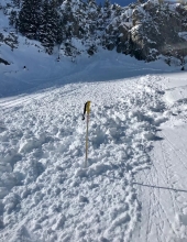
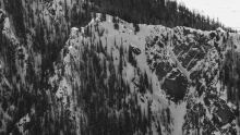
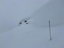
C-N-R2-D1.5
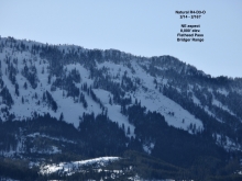
Elevation: 9,000
Aspect: E
Coordinates: 45.9043, -110.9580
Caught: 0 ; Buried: 0
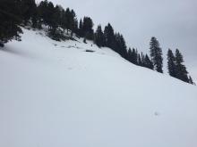
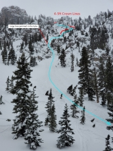
Skiers near Fairy Lake reported a cornice collapse in October Bowl.
More Avalanche Details
SS-NC-R1-D2-I
Elevation: 10,000
Aspect: E
Coordinates: 45.4111, -110.9880
Caught: 0 ; Buried: 0
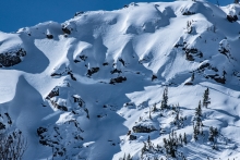
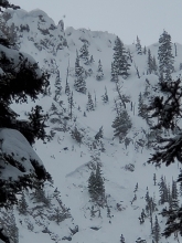
From obs. (3/29/20): "Significant wind started building mid morning, forming even bigger cornices and wind loading many slopes. Noticed this slide on an East/Northeast aspect at the back of the bowl above Maid of the Mist creek, possibly triggered by cornice fall but unknown. Happened between 9:45am and 11:30am today, as at 9:30am it was not there, and when we returned to the spot around 11:30am the slide was visible." Photo: CP
More Avalanche Details
Coordinates: 45.8591, -110.9550
Caught: 0 ; Buried: 0
After getting unstable snowpack test results, skiers on 3/27/2020 got a collapse on facets over a crust buried about a foot deep, near Ross Peak in the Bridger Range.
More Avalanche Details
SS-ASu-R2-D2
Elevation: 9,000
Aspect: N
Coordinates: 45.4174, -110.9890
Caught: 0 ; Buried: 0
From obs: Small D2 avalanche triggered while assessing the slope on a due-north facing aspect on a roughly 35-40 deg. slope at ~9000 ft. near Arden Lake in the Twin Falls drainage off the Main Fork of Hyalite. .... Had about a 2 ft deep, 30 ft-long crown. The bed surface was not clearly a sun-crust and was of low quality and remained relatively soft to ski on after the slide. There were crystals above that may be classified as facets, maybe 1mm dia. It seemed to have gone on a compacted layer that the 18" of fresh had weighted."
More Avalanche Details
SS
Coordinates: 45.4029, -110.9760
Caught: 0 ; Buried: 0
From obs: "Later in the day we ran across what we assume to be a remotely triggered avalanche from another party in the area. There were two sets of tracks on the adjacent slope with cracks visible on the slope. The avalanche occurred on a 40* east aspect at 9250' and failed on the MFcr/FC dn 35cm. .... Skiing out the trail with better light than in the morning, we saw a number of similar avalanches confined to east aspects on steep 40*+ rolls and presumably failing on the persistent grains above the crust."
More Avalanche Details
SS
Coordinates: 44.8524, -111.3920
Caught: 0 ; Buried: 0
Natural avalanches near Quake Lake, observed on 3/26/2020.
From email: "I observed several small natural slides originating on recently-loaded, corniced ridgelines. These all ran substantial distances, but did not pick up much snow or step down from the new snow."
More Avalanche Details
SS-AS-R1-D1.5
Coordinates: 45.8288, -110.9310
Caught: 1 ; Buried: 0
A skier triggered an avalanche on a windloaded slope just north of Bridger Bowl on 3/26/2020. The skier lost their ski in the slide.
More Avalanche Details
SS-R2-D2
Coordinates: 45.3539, -111.4050
Caught: 0 ; Buried: 0
Many natural and skier triggered avalanches were reported on wind loaded slopes in the Northern Madison Range on 3/26/2020.
Dudley Creek: "Was up Dudley creek today. Northern madison. Saw 2 step down avalanches on ne aspect high elevation... One ... seemed cornice triggered within 12 hrs of our tour this morning (3/26). The 2nd avalanche is in the lower photo and was probably skier trigger intentional.... It looks like they triggered a fresh wind slab under ridge, maybe ski cut, which stepped down into some older layers"
Beehive & Middle Basins:
-Two natural wind slabs observed on west facing slopes near the ridgeline in Beehive.
-4 skier triggered slides in the new snow on wind affected slopes in Beehive and Middle (observed/triggered by multiple parties)
More Avalanche Details
SS-ASc-R2-D1.5-O
Coordinates: 45.0931, -109.9510
Caught: 0 ; Buried: 0
Skier triggered avalanche in Goose Creek.
From obs: "Wind Loaded slope. 2ft Crown. 100ft wide. firm, crusty bed surface. The avalanche was released by a ski cut."
More Avalanche Details
SS-R2-D1.5
Coordinates: 45.0202, -109.9380
Caught: 0 ; Buried: 0
From email on 3/27/2020 : "natural slab avalanche I observed today near Cooke City. An easterly aspect around 9,400'. I'd estimate the crown to be 2-3' deep and about 100' wide. Looks like it was triggered by a cornice fall (2-3 days ago?)."
More Avalanche Details
SS-N
Coordinates: 45.8822, -110.9520
Caught: 0 ; Buried: 0
From obs: "We toured up in the Throne area today. Moderate winds were blowing snow at mid elevations and ridgetops. We found dry boot top powder on East facing slopes, the snow skied upside down. We observed loose and slab avalanches on many aspects up high and at mid elevations, all looked like new snow avalanches that happened yesterday. I’ve attached a photo of an east facing slope near the Throne." Photo: S. Jonas
More Avalanche Details
SS-N-R1-D1-I
Coordinates: 45.8156, -110.9230
Caught: 0 ; Buried: 0
1. Saw some really cool small avalanches today at Bridger. There was an obvious cycle last night on a density change, it wasn't sliding on the crust. The instability had decreased by 10 am and we couldn't get anything to move. Really cool to see such thin soft slabs propagating up to 50 ft. Good piles of debris under steep chutes.
2. Soft slabs were reactive on rocky south easterly aspects where sun crusts had formed.
More Avalanche Details
SS-ASc-R1-D1-S
Elevation: 10,000
Aspect: N
Coordinates: 45.4444, -111.0040
Caught: 0 ; Buried: 0
Snowfall throughout the afternoon fluctuated between S1 - S5 (during brief squalls). The winds started out moderate and from the west but calmed by the last lap ~5 pm. The new snow (from last night/this morning) was fairly well bonded to the sun/melt-freeze crust below, but the storm came in subtly upside down. Today’s snowfall (accumulating ~3” while skiing between 1-530) was light. Right along the ridgeline, we triggered 4 predictable small storm slabs 4~6” deep on the upside-down storm snow from last night/this morning, but surprisingly not on the old crust. They were each 5-10m wide x 5m long and only ran ~5m vertically.
More Avalanche Details
Aspect: N
Coordinates: 45.3126, -111.3110
Caught: 0 ; Buried: 0
From obs: "Was out today and found buried surface hoar 10-15 cms down. Some previous natural activity on this layer on steeper north aspects with very shallow soft slabs, but mostly dry loose at this point. Not much slab formation since the last ppt event. This could be a problem when more snow and wind in the next few days."
More Avalanche Details
WL-N-R1-D1.5
Elevation: 9,300
Aspect: S
Coordinates: 45.2995, -111.3200
Caught: 0 ; Buried: 0
From e-mail: "Natural wet slides [on 3/21]... caused us to back off our plan of heading that way and ski a north, shady aspect instead. On a southern aspect at 9000ft at 1:30pm we dug a hasty pit and observed a weak layer about 1m down. The facets were beginning to round." Photo: K. Master
More Avalanche Details
SS-ASu-R2-D1.5-I
Elevation: 10,100
Aspect: N
Coordinates: 45.3270, -111.3250
Caught: 0 ; Buried: 0
From IG post with #gnfacobs: "I triggered a small windslab, mid slope on the north face of Wilson. It was a a pretty stubborn slab that broke above me. Cross loaded from lookers right. 6-8” deep." Photo: B Gill
More Avalanche Details
HS-ACu-R4-D3-G
Aspect: N
Coordinates: 45.2630, -110.7070
Caught: 0 ; Buried: 0
Skiers on Emigrant Peak (outside advisory area) triggered a large cornice from the ridgeline. It broke 75' away from them and triggered a large avalanche when it hit the slope below. The avalanche broke 3-9' deep on weak snow near the ground. The avalanche was 150' wide and ran ~1000'. No one was caught.
More Avalanche Details
HS-ASu-R3-D3-O
Aspect: NW
Coordinates: 45.3048, -110.5430
Caught: 1 ; Buried: 0
Skier triggered avalanche on Knowles Peak in the Absaroka Range (outside of advisory area). Avalanche was triggered by 3rd skier on 3/20/2020.
From obs: "I need to report a pretty sizable avalanche that my group triggered today in the Absorokas up the East Fork of Mill Creek on a Northwest facing slope. I believe it was approximately a D3 in scale, the crown was 2-4 feet and about 600 ft wide. It ran to the ground in the start zone and carried debris about 2000ft vertical feet. The debris ran 200ft shy of the the East Fork Rd. It was triggered by the third of three skiers. The skier that triggered the slide took a slightly steeper (approx 34 degrees) line than the other two skiers. The crown started at a convexity in a shallower spot in the snow. We skied this slope last weekend and did a stability test and got a low energy ECT 22. We operated under the assumption that despite some new snow loading the snowpack was generally increasing in stability. We did a hasty pit to see how the new snow was bonding to the old snow surface and it appeared to be bonding well. Solar loading was a concern however this aspect seemed cold and there were no signs of rollers. We really thought this was a good to go situation. The third skier who triggered and was caught lost a ski but was able to ski out of the slide. The two skiers below traversed out of the slide path and kept eyes on the caught third skier. Skiers maintained visual contact at all times. We regrouped and amazingly found the lost ski in the debris pile. It was a scary moment to say the least. Thankfully we are all fine."
More Avalanche Details
WL-ASu-R1-D1
Aspect: E
Coordinates: 45.3145, -111.2950
Caught: 0 ; Buried: 0
Two skier triggered wet, loose avalanches. One was intentional and the other was unintentional (skier "went for a small ride on that one"). Both classified as R1/D1 size.
More Avalanche Details
SS-NC-R2-D2.5-O
Coordinates: 45.3539, -111.4050
Caught: 0 ; Buried: 0
Natural avalanche north of Beehive peak, next to North Twin behind the Fourth of July couloir. Looks to have broken on weak layers near the ground. May have been concern triggered. Observed 3/19/2020. Exact timing of release is unknown. Estimated 3/16/2020.
More Avalanche Details
WS-N-R3-D3
Elevation: 9,000
Aspect: E
Coordinates: 45.3145, -111.2950
Caught: 0 ; Buried: 0
Natural wet snow avalanche on the east face of Dudley, R3/D3 likely occurred Monday, March 16th.
More Avalanche Details
SS-ASc-R1-D1-I
Elevation: 9,000
Aspect: N
Coordinates: 45.9200, -110.9800
Caught: 0 ; Buried: 0
We intentionally triggered a small wind drift and cornice prior to skiing this north-facing line in Frazier Basin. The slab broke easily with a ski cut and propagated 20' in front of my ski tips.
More Avalanche Details

WL-N-R1-D1-I
Elevation: 8,000
Aspect: SE
Coordinates: 45.9043, -110.9580
Caught: 0 ; Buried: 0
We observed 7 wet, loose snow avalanches today in the Northern Bridger Range. All avalanches were in the R1, D1-1.5 size range. They would be consequential in the steep, technical terrain where they occurred.
More Avalanche Details
SS-NC-R1-D1.5-I
Elevation: 10,000
Aspect: NE
Coordinates: 44.9855, -109.9410
Caught: 0 ; Buried: 0
A small slab avalanche in the upper valley. A northeast aspect around 10,000'.
Also, there appeared to quite a bit more (thin) storm slab activity that occurred up Republic Creek yesterday (both east and west aspects). I'd hypothesize that most of the slides that ran yesterday, were on the density change within the new snow.
More Avalanche Details
SS-ASc-R1-D1-I
Coordinates: 44.8381, -111.3430
Caught: 0 ; Buried: 0
The steeps were inclined to move cohesively when ski cut, but no natural movement. Pretty good skiing, but greenhouse clouds warmed up the surface in the afternoon.
More Avalanche Details
WL-NC-R1-D1-I
Coordinates: 45.4253, -111.0120
Caught: 0 ; Buried: 0
From the Blackmore/Elephant saddle I observed what looked to be a less than a day old cornice break which triggered a loose wet slide in front of it. The cornice debris was large, about the size of a VW beetle. Also observed some surface hoar on the north side of the saddle.
More Avalanche Details
SS-N-R2-D1.5-S
Elevation: 10,000
Coordinates: 45.1170, -109.8930
Caught: 0 ; Buried: 0
From e-mail on 3/15/20: "At around 1230pm today, everything that was steeper than 35 degrees in star Creek simultaneously slid on east, north, south aspects. Soft slab 6-12" in thickness. Prior to that, it had been snowing S5 for three hours"
Another email 3/15/20: " observed a round of natural slab avalanches today, that seemed to run at about noon today on the north aspects of Mt. Republic. One was a couple hundred feet wide, and looked to happen within the new snow (6"? deep crown), but it stepped down to what appeared to be the new/old snow interface in a couple of spots as well. Significantly wide propagation and deep debris piles. The snow on Town Hill was cracking a lot early in the day around your skis, but seemed to settle relatively quickly,
More Avalanche Details
AMu-I
Coordinates: 45.0709, -109.9580
Caught: 0 ; Buried: 0
Doug talked on the phone with a snowmobiler who triggered a slide outside Cooke City today (3/15/2020). The details:
- It occurred somewhere between Round Lake and Lulu Pass, likely nearer to Lulu.
- It was snowing hard most of the day and they had poor visibility.
- The slide was triggered by 1 sledder. He was not caught.
- The avalanche broke 1 foot deep and 100 feet wide. It was believed to be new snow, but not wind-loaded.
More Avalanche Details
Coordinates: 44.9156, -111.3940
Caught: 0 ; Buried: 0
Small skier triggered slide.
More Avalanche Details
C-N-R2-D2.5
Aspect: E
Coordinates: 44.9855, -109.9410
Caught: 0 ; Buried: 0
The GNFAC saw this on Tuesday morning (3/10) from Woody Ridge. Winds were strong and loading slopes.
More Avalanche Details
Aspect: E
Coordinates: 45.7701, -110.9400
Caught: 0 ; Buried: 0
Observations from Bridger Ski Patrol:
"At 10:30 am natural avalanches were reported Between the Peaks of Saddle, in Argentina Bowl, and on Bridger Peak. At 11am a solo skier trigger an avalanche on the north peak of Saddle with a cornice drop. Shortly after, skier triggered avalanches were reported to the north, in Peter's Point, and Barny and Gibbs."
From a skier:
"Really touchy windslab formation throughout the day. 6-12 in slabs running on freeze crust."
More Avalanche Details
SS-ASc-R1-D1.5-I
Elevation: 9,300
Aspect: W
Coordinates: 45.3384, -111.3770
Caught: 0 ; Buried: 0
My partner and I toured over from Beehive into Middle Basin today (saw your car in the parking lot) and finding relatively dry snow in the shade headed for a west facing chute on the ridge that divides Middle and Bear Basins. The chutes walls kept it mostly shaded all morning and it was mostly cloudy as we started skinning up its apron. We had no cracking or signs of cohesion as we approached and a relatively easy boot pack up the chute. A couple of hand pits on the way up showed little cohesion within the top layer and a fairly dry snowpack underneath. We made plans for sluff management with protected spots to let it pass on both sides of the chute. While stomping out a platform we were able to kick off boot sized chunks of snow with no reaction My partner dropped first and his first turn kicked off a storm slab a couple of inches thick from his skis a few feet to his right against the wall of the chute. After a jump turn into a ski cut to one of those protected spots, he triggered a larger storm slab about 4” thick that propagated from the edge of our boot pack on one wall of the chute to the other wall about 20/30’ across and then ran the rest of the chute onto the apron about 300’ below us. No one was caught or injured. We skied out of the chute on the crust bed surface and spent the rest of the day enjoying some low angle trees. The chute was around 40° at 9,000’-9,500’ and west facing. We also noted a point release on an east aspect at about 9,300’ off the ridge separating Beehive and Middle Basin. It looked like a block of snow fell from a south facing cliff onto the slope below.
More Avalanche Details

WL-N-R1-D1-I
Coordinates: 45.4472, -110.9620
Caught: 0 ; Buried: 0
Today in Hyalite there was roughly 5" new snow. It quickly lost cohesion when the sun came out and many size 1 dry and wet loose came off of steep rocky areas. I did not observe anything larger. Yesterday I observed a cornice fall on an E aspect of Mt. Bole around 9500 ft that probably occurred on 3/6. It ran several hundred meters downhill, entrained some surface snow, and appeared to trigger a size 2 slab when it encountered steeper terrain. That being said I was at G1 so I didn't really get a good look at it.
More Avalanche Details
SS-AS-R2-D2-I
Elevation: 9,000
Aspect: E
Coordinates: 45.7932, -110.9350
Caught: 0 ; Buried: 0
Multiple laps on Saddle today. New snow peeling cleanly on hard crust on ski cuts at steep roll overs. Would run until pitch tapered off. Ran slow but pretty big. Debris was 4-6 feet deep. South Central (upper face) of South Saddle and Face of North Saddle under 2nd rock were the biggest producers.
More Avalanche Details
L-N-R1-D1-I
Elevation: 9,800
Aspect: E
Coordinates: 45.4445, -111.0020
Caught: 0 ; Buried: 0
Dry loose avalanches on Blackmore. The snow stayed surprisingly cold and dry throughout the day.
More Avalanche Details
WL-Nu
Coordinates: 45.4904, -110.4850
Caught: 0 ; Buried: 0
My partner and I were snowshoeing to Pine Creek Lake on Saturday 3/7 when we came across a large amount of avalanche debris piled up in the creek bed/gully of the north fork of Pine Creek. The toe of the debris started approximately right where the normal summer trail crosses the Pine Creek, and ran for probably a couple hundred feet up the creek bed. As we paralleled the creek on the south side, we could eventually see where it looked like the avalanche started, far up on the ridge to the north of the creek, at least another 1000 feet above. The debris looked fresh and very chunky/wet. That Saturday was very warm and sunny. We experienced a few small whumphs/collapses as we hiked up the south side of the creek. We ran into a couple other parties of skiers, but none of them commented on any other particular instabilities higher up towards Black Mtn.
More Avalanche Details
HS-ACc-R3-D2-O
Elevation: 8,700
Aspect: E
Coordinates: 45.4564, -111.0180
Caught: 0 ; Buried: 0
From an email:
More Avalanche Details

WL-N-R1-D1.5-G
Elevation: 7,500
Coordinates: 45.0202, -109.9380
Caught: 0 ; Buried: 0
From email: "[Near Mill Creek] We saw a natural wet slab that had released recently on a nw slope at around 7000’ (WS-N-R1-D1.5-G). Also got a big collapse on a sw aspect at about 7500’ on a moist layer of 4mm depth hoar. HS was only about 50cm where I got the collapse. Overall the snow was some wet hot garbage on all aspects,..."
Separate email: "Photo attached of some wet loose avy activity observed today just west of Cooke City (south aspect, around 8200'). Overall though, minimal wet avalanche activity observed with this significant warm up. No additional slab avalanche activity observed this week,..."
More Avalanche Details
Caught: 0 ; Buried: 0
Numerous small wet loose avalanches on 3/6/2020.
S. Gallatins - from email: "Five small wet slides across the big sky trail in Buffalo Horn this afternoon. The biggest was probably 120’ long and 50’ wide."
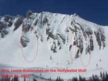
Bridgers - "Saw some small avalanche activity. A few wet loose on east to south aspects... Wet loose activity I saw was D1 on Bridger peak from below high cliffs. 2x D1.5s in Argentina Bowl. and 2-3 other D1s near the Throne. Largest was on the Hollywood Wall in Frazier where I saw a debris pile of D2 size, but can’t tell if it was loose or slab."
S. Madisons - "Slopes across from Bacon Rind. 8 or so natural D1 wet slides. Points releases to small wet slabs."
More Avalanche Details
Coordinates: 44.9205, -111.2300
Caught: 0 ; Buried: 0
From obs: "On Thursday my group skied a few lines off the Lee side of skyline. Generally, all stability observations but one were good except for 1. We were skinning cross slope along the top of the apron toward the bottom of a couloir on the north aspect of White Peak to recon the couloir for possible ascent and skiing. As we approached the opening of the couloir, a large collapse occurred on a firm wind slab and a crack shot out across the bottom of the couloir an unknown distance. (We deemed it unwise to further investigate given the slope angle was nearly 40 degrees. It was quite puzzling the slope did not slide upon collapse and we were not about to further poke that bear.)"
More Avalanche Details
HS-NC-R1-D1
Coordinates: 45.0722, -109.9280
Caught: 0 ; Buried: 0
From email "Cornice releases off Sheep Mountain that stepped down and released a wind slab within the start zone."
More Avalanche Details
WL-AS-R1-D1
Aspect: S
Coordinates: 45.8586, -110.9560
Caught: 0 ; Buried: 0
From email: "Steep south facing slopes would readily push small loose wet slides if you were skiing it, all other solar slopes took heat but didn’t seem to heighten the avalanche danger. "
More Avalanche Details
C-NC-R1-D1.5-S
Elevation: 9,250
Aspect: NE
Coordinates: 45.1807, -111.4090
Caught: 0 ; Buried: 0
Cornices are growing very large in Buck Ridge area. This one failed about 100' across and took a bit of wind pillow with it, but did not break into deeper weak layers.
More Avalanche Details

Aspect: NE
Coordinates: 45.1842, -109.6760
Caught: 0 ; Buried: 0
Reported on 3/1/20 Likely 1-2 weeks old: "We saw a massive cornice triggered slide with a crown of roughly 20-30ft on a NE aspect above East rosebud lake."
More Avalanche Details
HS-NC-R2-D2
Aspect: E
Coordinates: 45.1534, -111.0930
Caught: 0 ; Buried: 0
The date of the avalanche is a best guess based on other activity.
From an email, " It did look like the east face of Ramshorn Peak slid pretty recently. The blowing snow and clouds weren't conducive to good pictures but you can see the crown line below and to the right of the summit. Looked like a cornice fall triggered it."
More Avalanche Details
SS-AS-R1-D1-S
Elevation: 9,000
Aspect: S
Coordinates: 45.1628, -111.5290
Caught: 0 ; Buried: 0
While approaching Black Mountain from Pine Creek Lake. Noticed two dry loose snow problems on the way up near rock bands on North facing aspects at 9500'. R1.5 D1. Winds were powerful around 30mph at the summit and on the approach our major concern was wind slab problem reacting around 5 inches deep. We skied South aspect and as it warmed we triggered D1 R1 slabs that ran slow and short. Although we never skied on substantial slabs, we were eager to get moving and out of any run outs.
More Avalanche Details
SS-N-R1-D1.5-S
Elevation: 9,300
Aspect: NE
Coordinates: 45.0202, -109.9380
Caught: 0 ; Buried: 0
From email 2/28: "Photo attached of a natural avalanche from yesterday, just south of Cooke City. It's on an E, NE aspect, with a crown around 9,300'. Looks like it occurred yesterday am, as a result of a cornice fall.
Additionally we observed quite a few natural, point release avalanches on mid elevation easterly aspects yesterday too. Lots of sunshine, and temperatures in the valley bottom slightly above freezing yesterday.
Overall we didn't find the fresh wind drifts to be too widespread though."
More Avalanche Details
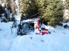
SS-AKu-R3-D3-O
Elevation: 7,800
Aspect: W
Coordinates: 45.3761, -111.0940
Caught: 1 ; Buried: 0
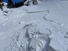
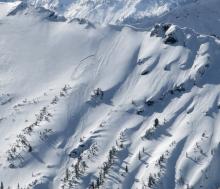
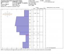
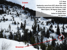
GNFAC investigation: We went and looked at the avalanche that partially buried a groomer without injury to the driver at 8:15 p.m. the night before (2/27). The slide broke on facets at the ground and was 2-3' deep, 100' wide, and ran 600' slope distance. It put 8' of debris on the road cut. The slope was west facing at 7,500' and averaged 38 degree steep in the starting zone. Weak snow at the ground is found throughout our advisory area.
The groomer triggered the avalanche when he was clearing a wind drift from the road. The groomer is badly damaged.
Crown: N45.38528, W111.06487, 7802 feet
Toe of debris: N45.38554, W111.06693, 7482 feet
Alpha Angle: 30 degrees
Billings Gazette Article HERE.
More Avalanche Details

Coordinates: 45.0265, -111.0480
Caught: 0 ; Buried: 0
From email: "Very Substantial collapse and shooting crack on a SW facing meadow on a 30 degree slope around 8700’ acting on DH. Crack separated around an inch and a half."
More Avalanche Details
SS-N-R2-D2.5-O
Elevation: 9,300
Aspect: NW
Coordinates: 45.3934, -110.9690
Caught: 0 ; Buried: 0
Timing uncertain, but the avalanche occurred sometime after the last significant snowfall on Tuesday 2/25/2020.
From observation: "Saw this avalanche that broke on a NW facing slope around 9300’. Looks to have failed on the facets at the ground ... the crown was 4-5’."
More Avalanche Details
HS-NC-R3-D2.5-O
Elevation: 8,300
Aspect: E
Coordinates: 45.8330, -110.9380
Caught: 0 ; Buried: 0
HS-R3-D3
More Avalanche Details
SS-AM-R1-D1
Coordinates: 45.0202, -109.9380
Caught: 0 ; Buried: 0
Observed two small natural wind slab avalanches on the morning of 2/25 near Daisy Pass.
Then saw four small snowmobile triggered slides on windloaded slopes near Goose Lake that were triggered today. These slides broke 1-2' deep on small slopes.
More Avalanche Details
HS-AMu-R2-D2-O
Elevation: 9,100
Aspect: S
Coordinates: 44.8726, -111.8190
Caught: 0 ; Buried: 0
Isolated 5' crown, ran 100 yards wide.
More Avalanche Details
HS-N-R3-D3-O
Elevation: 9,000
Aspect: SW
Coordinates: 45.1582, -111.4770
Caught: 0 ; Buried: 0
On sunday 2/23/20 skiers near Sphinx Mtn. saw a recent 2-4' deep natural avalanche that broke on old persistent weak layers. Best estimate for timing is between 2/16 and 2/22. from IG: @skishot
More Avalanche Details
WL-N-R1-D1
Elevation: 8,500
Aspect: S
Coordinates: 45.0265, -111.0480
Caught: 0 ; Buried: 0
From an obs on 2/23/20: "...today toured up above 9000 ft on Meldrum and some surrounding hills.... No cracking, collapsing, or naturals observed aside from some small wet loose that occurred yesterday in steep S rocky terrain at 8500 ft.... HS 150+ with depth hoar 130 down. The new snow will be falling on a variety of snow surfaces from crusts (E-S-W) to wind board (ridgelines) to NSFs (N). Temperatures warmed to above freezing today to at least 9000 ft. Winds increased to moderate out of the west by 1400 with some wind transport occurring at ridgelines."
From another group on Electric Peak on 2/23/20: "One recent natural avalanche near the ridgeline roughly 30 cm deep probably due to wind loading (D1) and a handful of natural loose wet (D1) avalanches on southerly aspects. Dug a quick pit on the face (10700’ NE 30 degree slope HS 190cm) and got an ECTP23 @ 35 below the surface on a hardness change below a 1F fresh windslab... Also, bulletproof windboard below the first roll (@10200’) and cranking winds!"
More Avalanche Details
HS-AM-R1-D2-O
Elevation: 10,000
Aspect: SW
Coordinates: 45.0706, -109.9520
Caught: 0 ; Buried: 0
"Seemed stability was getting better, but did see this minor slide that pulled out on Scotch Bonnet Mountain. Evidently triggered by a snowmobile sometime mid-day Saturday."
More Avalanche Details
SS-AMu-R2-D2
Coordinates: 44.7292, -111.3230
Caught: 0 ; Buried: 0
From IG message: "Was riding up lions head today. Was on the same channel as another group and a member of their group came over the radio and said that he had to roll his sled and it triggered/buried his sled. Didn’t get much more info but he was very spooked over the radio. Looked hard on our way out and couldn’t find the slide."
More Avalanche Details
Coordinates: 45.0530, -110.0100
Caught: 0 ; Buried: 0
"While sled skiing a bowl over, we noticed the second half of a natural slide. We forgot to go over and take photos, but it seemed like it was either a cornice break or a point release, and slid somewhere around 1,000 feet."
More Avalanche Details
SS-AS-R2-D1.5-I
Elevation: 8,000
Aspect: S
Coordinates: 45.0202, -109.9380
Caught: 0 ; Buried: 0
From email on 2/21/20: "...observed today from the highway. It appears like it was probably triggered by a skier yesterday (on Feb. 20). It was on a south aspect around 8,000', and estimated to be 1-2' deep and about 30' wide.
Additionally, there were a couple of wet, point release avalanches that ran today on other southerly aspects, due to abundant sunshine and warming temps. Aside from that, no other slab avalanche activity nor signs of instability observed this last week around Cooke City."
More Avalanche Details
SS-AS-R1-D1
Coordinates: 45.8406, -110.9330
Caught: 1 ; Buried: 0; Killed: 0
From email on 2/20/2020: "I found some localized instabilities, including some wind whales on the ridge north of Bradley’s... The slide in the photo probably happened naturally this late morning, with a trigger of sun-heated snow from the cliffs above (just west of Texas Hill). It ran approximately 100 meters.
From e-mail on 2/21/2020" "I was a few hundred feet north of it when it released. It was skier-triggered by another party traversing high on that slope. It carried the skier for most of the slide path."
More Avalanche Details
SS-N-R3-D2-O
Elevation: 8,500
Coordinates: 45.4504, -111.2240
Caught: 0 ; Buried: 0
On Saturday 2/22/20 riders saw natural slides on east and west aspects 10 miles up Storm Castle creek.
More Avalanche Details
HS-N-R3-D2-O
Elevation: 9,700
Coordinates: 45.4900, -110.4950
Caught: 0 ; Buried: 0
More Avalanche Details
HS-N-R3-D3-O
Elevation: 9,700
Aspect: NE
Coordinates: 45.6553, -110.5580
Caught: 0 ; Buried: 0
From IG #gnfacobs post: "An avalanche from early Tuesday (02/18) morning caused by a natural cornice fall. Note the step down partway down the path. ENE @ 9700. Ran 1300’."
More Avalanche Details
HS-N-R3-D2.5-O
Elevation: 8,000
Aspect: NE
Coordinates: 45.9684, -111.0210
Caught: 0 ; Buried: 0
Natural avalanche crowns were seen on 2/20/2020 near Flathead Pass that appear to be from the last 2-3 days. They were fresher than crowns that were seen here on 2/9, and these slopes had not slid when the area was visited on 2/9.
More Avalanche Details
HS-N-R2-D2.5-U
Elevation: 10,200
Aspect: S
Coordinates: 45.3270, -111.3250
Caught: 0 ; Buried: 0
By far the most interesting thing today is an avalanche cycle on the south face of Wilson Peak. Multiple avalanches, some breaking on planar faces, scattered all across the thing. Not sure on depth either- some look quite deep, but I’m wondering if it is the storm snow from the mega-storm 2 weeks ago running on the rock hard surface leftover from the 100+ mph wind event 2.5 weeks ago. We will look more closely with binoculars tomorrow for a better estimate of scale. The slopes were obviously cross-loaded, but we were interested in what exactly made them cycle today (or last night).
More Avalanche Details
SS-AMu-R1-D1.5
Aspect: S
Coordinates: 45.0202, -109.9380
Caught: 0 ; Buried: 0
"A small slide approx 100 ft wide ran about 40 vertical feet. Crown was 3-4 feet deep. Aspect, SE. Trigger unknown however tracks indicate it was likely a snowmobile trigger."
More Avalanche Details
AMu-R4-D2.5-O
Elevation: 9,300
Aspect: E
Coordinates: 45.1719, -111.3800
Caught: 0 ; Buried: 0
"Went out on a recon to Buck Ridge today. New the dangers and avoided riding open slopes. I had been riding trees most of the day down low and moved up to about mile marker 10 later in the day. Did a side hill through open trees and stopped on top of this slope. Watched it all propagate and slide below me."
More Avalanche Details
HS-N-R4-D3-O
Elevation: 9,800
Coordinates: 45.2630, -110.7070
Caught: 0 ; Buried: 0
[date of activity roughly estimated] From email on 2/22/2020: "The mountains around Emigrant Peak have certainly reached their tipping point. Skinning up in the morning we witnessed the debris of more than a dozen avalanches on all aspects, more than I have ever seen in a single day. Many of these avalanches were extremely large and powerful deep slabs that broke towards the ground, likely to have released within the past week. Slides were running to the end of their runout zones and carried with them many trees that were torn to shreds."
More Avalanche Details
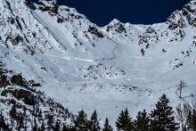
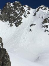
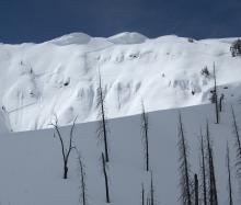
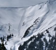
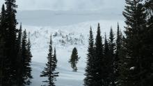
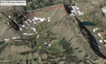
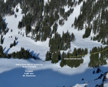
HS-N-R4-D3.5-O
Elevation: 9,900
Aspect: SE
Coordinates: 45.4164, -110.9700
Caught: 0 ; Buried: 0
Skiers saw these deep slabs in Maid of the Mist in Hyalite on 2/21/20. Doug Chabot went to the site on the 2/22.
The avalanches were big and deep. They ran on the facets/depth hoar near the ground. The slide (1&2) ran to their maximum runout.
Aspect: South to East
Elevation: 9900'
Slope Angle: estimated 45+ degrees at the steepest with average of 40 degrees.
Using Google Earth
Crown: 9930'
Toe of Debris: 9316' with a measured Alpha Angle of 16 degrees
- Latitude: 45°24'49.65"N
- Longitude: 110°58'49.04"W
Using picture "4 avalanches..." as reference:
- was 300' wide, 6-8 feet deep
- 1300' wide; it ran from east to south aspect; was 10-12 feet deep; ran 2150' slope distance,
- was 150' wide, 450' slope distance, 4-5 feet deep
- was 250' wide and had a measured Alpha Angle of 26 degrees, 4-5 feet deep and ran 775 slope distance.
More Avalanche Details

Elevation: 6,800
Coordinates: 45.5777, -110.9550
Caught: 0 ; Buried: 0
A group reported: "On Sunday afternoon my partner and I skinned up Bear Canyon and proceeded a half mile south along the ridge from the top of the ski hill. We were considering skiing a treed gully off the ridge down into Shoefelt gulch or skiing the East side of the ridge back into New World Gulch. As we skinned out of the trees (@ 6,800 ft) and out into the meadow above our prospective runs I caused a very audile collapse and it was obvious the wind had done a lot of work moving snow on to the east facing slope. We dug a snow pit, on a west facing slope, about 30 feet down from the ridge. The snowpack in our pit was 95CM deep, we did an extended column test and got an ECTP 13 which failed on the facets near the ground. The slab was ~70 CM. We decided to dig another pit on the east facing slope just across the ridge, making sure not to get too close to gully which looks like a slide path. My partner dug out the majority of the pit and then I joined him to perform another ECT. Just before we isolated our column my partner stepped out of the pit for a second and on he triggered another extremely audible collapse that seemed to have traveled a decent ways across the slope to the north of us, towards the gully. We got an ECTP 12 from this pit, it broke on the facets near the ground and the slab was about 80CM, the snow depth was 100CM. I thought it was interesting that we did not see much cracking while we were skinning or digging our pits, that being said the new snow from this last storm cycle was very dense and it was easy to get it to sheer when we were digging pits but we did not see it collapse. We knew going up that we probably couldn't ski any of what we checked out but had good time looking at the snowpack and skiing with the dogs back down the ridge to Bear Canyon."
More Avalanche Details
"We observed an avalanche on a southeast face while touring in the Absorokas. The avalanche appeared to be naturally triggered earlier in the morning as there were no tracks and my partner and I was the only party in the area today. The avalanche appeared to break on the ground, was about 200 feet wide and ran 600 feet. It was the only avalanche we observed today and was on a relatively shallow slope compared to other regions. We had observed widespread whumpfing and collapses throughout the day."
More Avalanche Details
Coordinates: 45.4444, -111.0040
Caught: 0 ; Buried: 0
"Toured up Blackmore today, we had shooting cracks under our feet along the north east ridge line."
More Avalanche Details
SS-N-R2-D2-O
Elevation: 8,400
Aspect: E
Coordinates: 45.8301, -110.9340
Caught: 0 ; Buried: 0
"We came across the debris of a significant slide in one of the steeper lines just north of Wolverine bowl today. There was zero new fallen snow on the debris so it happened sometime this morning before 11:30 a.m. and after the snowfall stopped last night. The multiple crowns looked to be 3-5 feet tall and a large tree has been jammed into the tube ride chute. The toe of the debris is all the way down into the creek at the base of Wolverine. It's possible a large cornice broke off at the ridgeline but we couldn't get eyes on the actual start of the slide. We skinned up and down the debris pile twice while in search mode at around 12:30 but did not pick up a signal. We did not investigate above the pinch of the chute and into the upper part of the slide. The debris pile is quite deep with some damaged trees. We did 6 lines off the ramp over the weekend and did not see any other avalanche activity but obviously some significant wind loading."
More Avalanche Details
SS-N-R4-D2-O
Elevation: 7,000
Aspect: E
Coordinates: 45.6057, -110.8810
Caught: 0 ; Buried: 0
From an observation, "R3-4 D2 avalanche that failed at the ground observed from the Trail Creek Rd. Looked to be several hundred feet wide, couldn’t see the debris, but crown went through lots of trees."
More Avalanche Details
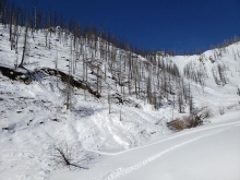
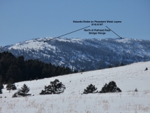
HS-N-R4-D3-O
Elevation: 8,000
Aspect: NE
Coordinates: 45.9684, -111.0210
Caught: 0 ; Buried: 0
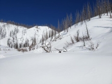
"Quick Obs from a tour up to the skiing just south of Flathead Pass [2/17/2020]. We headed that direction for some low-angle protected tree skiing and, instead, found evidence of a widespread natural avalanche cycle from 2~3 days ago.
There were 3 main avalanches with similar characteristics: HS - N - R4 - D3 - O.
- Crowns topped out around 8000’ with large amounts of hanging snow (on steep slopes) above. Interestingly, the crowns connected down slope as low as 7800’ and jumped from tree to tree along convexities. The avalanches’ crowns ranged from 100’ wide to over 500’ wide.
- The avalanches failed on 4F- 1.5mm facets above the Thanksgiving crust, which was substantially harder than I have seen in the southern Bridgers.
- The avalanches stepped down to well-developed depth hoar (below the crust) in a few locations.
- The average crown depth was ~140cm where we felt safe looking (near bottom of crown) but was significantly more shallow near some trees.
- Conducted a quick crown profile and some tests. The standout results are PST 25/120 END x3 (we conducted the PST at a spot where the weak layer was buried 120cm deep) on the persistent weak layer with no notable results in two separate location ECTs and additional deep tapping…).
- The debris piles extended to previous old-growth maximums (extending the path of at least one avalanche) and had many snapped trees up to 10” in diameter deposited within."
More Avalanche Details
Coordinates: 45.1628, -111.5290
Caught: 0 ; Buried: 0
While touring up black mountain on Saturday, February 15th 2020, our group heard very loud whoofing on flat ground, collapsing large areas. There was small cracks formed but we were on very low angle slopes. We switched to a back-up plan to get down. A second large whoofing occurred minutes later a short distance away from the first. This time we could feel the snow drop below us by a few inches. We turned around and followed our tracks down. We dug two pits in the vicinity of the collapsing. Two extended column tests produced failures on the same depth hoar at the ground, ECTP 23 and ECTP 16. The latter result was on a pit of at least a meter deep. WE collapsed another flat while skiing down. No other obvious signs of instability were seen.
More Avalanche Details
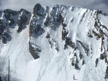
HS-N-R4-D3-O
Elevation: 9,400
Coordinates: 45.4467, -111.0040
Caught: 0 ; Buried: 0
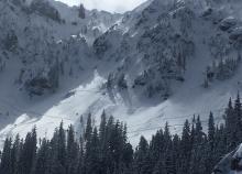
From an observation on 2/16: "My partner and I skied off the north-north east ridge of Mt Blackmore into the Fox Creek drainage and observed five recent, naturally-triggered avalanches from the recent storm. Three D1 avalanches were scattered across the bowl from the north, northeast and north-northeast aspects next to exposed rock-outcroppings but were too small to capture in a photo. A fourth, D3 R3 avalanche occurred at approximately 9200' on the north aspect that appeared to have broken right at the bedrock and slid approximately 200 vertical feet. Crown looked to be up to 6' deep and 600 feet across. The fifth, D3 R4 avalanche occurred at approximately 9400' on the north-northwest facing aspect in a narrow meadow. Crown was approximately 8' deep and 30 feet across (the width of the meadow). There was rapid wind-loading still occurring on the aspects of the two D3 avalanches covering up their slide paths and we observed significant wind-loading and cracking off the northeast ridge line."
From a separate group on 2/16: "Took a walk up near Blackmore today to take a look at a NE facing aspect. We did not ski our objective because we observed active wind loading and saw many recent avalanches.
The first picture is looking at Alex Lowe Peak from the west ridge of Elephant. There were 5 avalanches clearly visible. I highlighted the crowns/debris paths with red.
The second picture is a close up of the avalanche on the ridge between Elephant and Blackmore on a south aspect. This one was the largest and the most fresh. All avalanches appeared to be naturally triggered from wind loading.
We also saw an avalanche looking north from the NE ridge of Elephant over the east ridge of Blackmore. The avalanche was on a south/southeast facing hill and looked like it broke at the ground. It was pretty sizable. We didn't get a picture, but this looks like it would've been visible from the east ridge of Blackmore looking north."
Forecasters visited the area on 2/21/2020: Saw over 15 old avalanches. Estimate an additional 8 that the above groups did not report, so a total of 18+ in the area during the cycle.
More Avalanche Details


SS-AMu-R2-D2-G
Coordinates: 45.0607, -111.2720
Caught: 1 ; Buried: 0
Slide in Taylor’s fork crown of about 5-6’ and abou100' wide. Human triggered.
More Avalanche Details
Coordinates: 45.0668, -111.0500
Caught: 0 ; Buried: 0
1. Massive rolling collapse on lower ridge of ascent on Big Horn Peak. Felt like it went out hundreds of yards uphill. No avy activity. Other various collapses while skinning up ridge. 2+ weeks ago the lower ridge only had about 40-50 cms on it, so was not surprised to have that happen after large amounts of loading.
2. Specimen Creek: Heard several whumpfs and saw shooting cracks. No avalanche triggered, but a very unstable snowpack. Some whumpfs traveled farther than others. Very deep snow, fell to about knee height on parts of the trail, even in snowshoes...many shooting cracks and loud, traveling whumpfs as well as shaking ground from settling snow. This was relatively far from avalanche terrain on flat ground. Snowpack very unstable.
More Avalanche Details
HS-N-R3-D3-O
Elevation: 9,200
Aspect: N
Coordinates: 45.4494, -111.0760
Caught: 0 ; Buried: 0
Very large avalanche photographed from Gallatin Gateway at the head of Little Bear Canyon. This avalanche likely occurred Saturday or Sunday during the loading event as there is snow on the debris pile.
More Avalanche Details

SS-N-R1-D2-O
Elevation: 10,200
Aspect: E
Coordinates: 44.9739, -109.9240
Caught: 0 ; Buried: 0
From an observation, " Climax slid quite large several days ago. We could get a good look at the crown because of the wind, but I’m guessing it was a wind slab that stepped down."
"Climax" is the what the locals call the large east face on Woody Ridge above Hayden Creek.
More Avalanche Details
HS-N-R4-D3-O
Aspect: N
Coordinates: 45.3048, -110.5430
Caught: 0 ; Buried: 0
1. "Large (presumably natural) avalanche seen on the north face of Knowles. 3ft deep crown, 300ft wide and probably a 100k ft run. Multiple broken trees in the debrisfield. Collapsing on 4" of sugary facets at the ground. Cracking, whoomphing, collapsing, etc found on all aspects on the ascent."
2. Photo is from February 12, Knowles Peak from Moo Creek.
More Avalanche Details
SS-N-R2-D1.5
Aspect: W
Coordinates: 45.5243, -110.9560
Caught: 0 ; Buried: 0
From an observation, "This activity appears to have occurred naturally. No signs of a skin track or skiing. No accurate indication of when it happened, tho appeared fairly recent with no new wind loading."
More Avalanche Details
HS-N-R4-D3-O
Elevation: 9,600
Aspect: N
Coordinates: 45.4272, -111.0140
Caught: 0 ; Buried: 0
From an email:
"Near the ridge line of Mt. Blackmore we noticed the East facing slope close to the ridge line was clearly wind loaded and felt collapsing and cracking under our skis. None of those cracks shot out however. We dug a pit on an E- SE facing slope near the ridge line and found no signs of stability, however we ran into a group on our way up who said they dug a pit in a similar area and got an ECTP-22. Looking N-NW from the ridge line we saw some an avalanche crown on the adjacent face (Alex Lowe Peak)."
This is the second time this avalanche path released. See a photo from 1/25/20 HERE.
More Avalanche Details
HS-N-R4-D2.5-O
Elevation: 9,500
Aspect: NE
Coordinates: 45.3344, -111.3720
Caught: 0 ; Buried: 0
We encountered a natural avalanche that appears to have been triggered by a cornice drop. There seemed to be very little fresh snow on the slide surface so we suspect it occurred recently (Feb 14?). The slide occurred on the west side (east facing side) of Bear Basin (pinpoint on the map below). The avalanche was probably 200 feet wide at the top so it clearly propagate across the slope. Crown was 2 to 5 feet tall. We did not hike in there to investigate more carefully. There is a fair amount of trees on this part of the ridge. The picture shows how some large chunks got hung up on trees but we could see that the slide ran across the creek below (almost 1000 vertical feet). We had planned on skiing this slope and/or the open meadow (talus field) a hundred yards north but in light of this observation we turned around, skied back down in Middle Basin in the trees. Side note: we dug a pit earlier on an almost identical aspect (on the Beehive/Middle basin ridge) and obtained ECTN 16 @ 12" below the surface, ECTN 23 @4" below that, ECTN 28 @ 6" below that... Basically some definition between the latest storm layers but no propagation, and a right-side up snow pack. We only dug about 3 feet deep so this pit did not assess the ground level facets, which we figure are wide spread. The natural slide we encountered one ridge over seemed to be a case where a thin area was triggered by a cornice drop.
More Avalanche Details
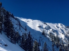
HS-NC-R5-D3-O
Elevation: 10,000
Aspect: E
Coordinates: 45.3934, -110.9690
Caught: 0 ; Buried: 0
1. Observed a sizable deep slab in the Divide basin which appeared to have run within the last few days. The crown extended from the southern end of the basin (northeast facing) through the summit run off Divide (southeast facing)--maybe around a mile. Slab height varied, with the upper end pushing 10 feet and the lower closer to a foot or two. On Divide, the crown approached the summit and debris had run across the flat to the mature trees. Looked like it may have been cornice triggered at the southern end on thinner cover in rocky terrain.
2. Skied the NE shoulder of Divide Peak. Spotted a 1/4 to 1/2 mile long crown spotted along the NE face of Peak 10,024, between Divide Peak and Hyalite Peak. We could not directly determine the crown height, but it was highly visible from our location ~1 mile away.
3. Several large avalanches along the west ridge of divide basin. Appeared to be set off by large cornice drops that propagated across the bowls and stepped down several feet into the snowpack.
More Avalanche Details
N-R4-D3.5-O
Elevation: 7,900
Aspect: S
Coordinates: 45.5090, -111.0670
Caught: 0 ; Buried: 0
We skied Wheeler via South Cottonwood and found that the two gullies on the East and South East aspects had recently run in their entirety. We could only see the crown on the South East gully but it appeared to have broke on the steepest part of the slope near the top approximate 3-4ft deep and was the width of the gully. Both avalanches ran the full length and width of their gullies, breaking several trees along the way. The East debris pile was about 25ft deep and the South East was 15ft deep. The East rounded the corner into the ravine at the bottom and also ran about 200ft into the forest. A couple larger trees in the path that were not broken had their branches stripped off the bottom 30ft. Interestingly, the narrow meadow between the South East gully and the South East meadow you recently reported slides on has not slid. Also, we had no propagation or collapsing in our pits.
More Avalanche Details
SS-NC-R3-D2
Elevation: 9,300
Aspect: S
Coordinates: 45.2995, -111.3200
Caught: 0 ; Buried: 0
Cornice fall triggered a soft slab avalanche in the Spanish Peaks on the afternoon of 2/13/2020.
From email: "100 feet wide, slid the new snow layer maybe 2-3 feet deep, made a pretty good runnel, and went close to full path , so it must have entrained a decent amount of snow to travel that far .."
More Avalanche Details
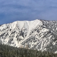
SS-AMu-R2-D1.5-O
Coordinates: 45.1834, -111.4400
Caught: 1 ; Buried: 0
From observation: "My riding group came upon a group of three riders from out of state digging out a sled. A single rider had been side hilling a steep slope above a deep creek drainage. This is where the trail leaves Third Yellow mule and drops into McAtee. The slope broke with a single rider high on the slope completely burying the sled. The rider managed to stay on top of the debris. The debris was very deep (~12'-15') as it filled in the drainage below."
More Avalanche Details
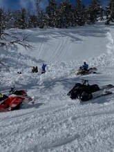
HS-ASr-R1-D1-O
Elevation: 8,000
Aspect: NW
Coordinates: 45.4240, -111.2050
Caught: 0 ; Buried: 0
Two avalanches simultaneously remotely triggered by skiers on Wednesday, 2/12/2020.
From email: "NW aspect at 8000 ft on Garnet Mountain. Two slides, one 15 feet across and one 10 feet across, remotely triggered from 15 ft away. Crown was about four feet deep, triggered on the facets. Didn't travel more than 30 vertical feet. One slide triggered in dense trees, and both slides traveled into densely treed areas. The snowpack was relatively shallow in the area where slide was triggered. Signs of instability were noted (Back on low angle terrain, after triggering the above slide), Cracks that propagated out 10+feet and were very deep and whomphing."
More Avalanche Details
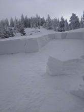
SS-ARr-R1-D1-S
Elevation: 6,700
Aspect: NE
Coordinates: 45.2988, -111.2040
Caught: 0 ; Buried: 0
"Today while touring in the Deer Creek drainage in the Northern Madisons my partners and I noticed many red flags. Wind was strong from the WSW. We had lots of collapsing and some cracking while touring up. We bailed on our main objective, and while returning to the car we triggered a wind slab remotely from the bottom flats of a gulley. A rider in our group began to descend when we felt and heard a large whumph, followed by a 3-5 second loud rumbling before a wind slab on the ridge above (100 yards away) released (SS-ARr-R1-D1-S, NE aspect @ 6700'). It was about 50' wide and 1-2' deep, but didn't have enough energy to run far down the slope. Touchy stuff!"
More Avalanche Details
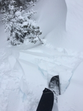
Elevation: 8,000
Aspect: E
Coordinates: 45.5777, -110.9550
Caught: 0 ; Buried: 0
"I observed this collapse & propagation as I stepped over some wood in the skinner on the north ridge of Mount Ellis this morning, ~8000’, due East. I was tailing Chabot and his partner, and they had passed this way just minutes before."
More Avalanche Details

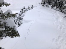
HS-N-R3-D2.5-O
Elevation: 8,000
Aspect: NE
Coordinates: 45.9684, -111.0210
Caught: 0 ; Buried: 0
We drove to Flathead Pass to look for avalanches from the recent storm and saw widespread crowns that were fresh enough to have ran during the end of the storm. A couple broke in the 3 feet of storm snow, b ut many were 3-5' deep on persistent weak layers.
More Avalanche Details
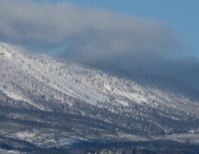
SS-AMu
Coordinates: 44.9041, -111.1850
Caught: 0 ; Buried: 0
"...were up in Tepee today, we saw a couple small slides the one below look to be caused from a snowmobiler and we saw one other one high on the Whites peak ridge that looked to be a natural slide or maybe caused from a piece of cornice that broke off. The rest of the ridge along White Peak also looked to be loaded up..."
More Avalanche Details
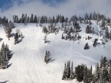
Coordinates: 45.5777, -110.9550
Caught: 0 ; Buried: 0
Two parties reported, "Widespread wumphing and cracking on Little Ellis (both on the north side and east facing meadow above)." and "We skinned up the road and planned to ski the eastern meadow below Little Ellis. As soon as we began skinning the meadow, heard, and felt, a significant "whomp" so decided to play it safe and leave the area."
More Avalanche Details
SS-N-S
Elevation: 9,000
Aspect: NE
Coordinates: 45.8586, -110.9560
Caught: 0 ; Buried: 0
"Skied the low angle trees on the NW side of Ross today around 8000 ft. Saw a natural wind slab that had released during the day around 9000 ft. NE aspect, I'd estimate 40 degree slope but I wasn't very close. Moderate to strong winds most of the day."
More Avalanche Details
SS-N-R2-D2
Coordinates: 45.0202, -109.9380
Caught: 0 ; Buried: 0
1. "...a fresh avalanche observed out there today. A south aspect around 9400', estimated to be 2-3' deep and 75' wide. Also observed 2 thinner wind slab avalanches that also ran naturally within the last 48 hrs, and were both about 1' deep and 50' wide. One was a SE aspect, and one was a North aspect." See attached photo Natural avalanche 2-3' deep.
2. "We’ve seen many instances of cracking and wind slab breaks the past two days riding in Cooke, most happened as we sledded past or down the slope. The 1st and 2nd photo are 4” deep breaks at most. The last photo/slide we observed today, S facing slope, not sure how it was triggered, a foot deep crown at most." See attached photos Small 1' deep, Human triggered 1&2.
More Avalanche Details
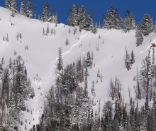
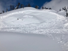
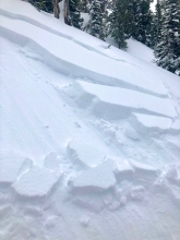
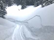
HS-N-R4-D3.5-O
Elevation: 8,500
Coordinates: 45.8139, -110.9330
Caught: 0 ; Buried: 0
Avalanche crowns spanned almost the entire ridge of Truman Gulch. They connected, but appeared to run at different times. The most recent was probably last night behind the Patrol lift. Looked very fresh today without any snow on it. In your face/Catch a wave was a day or two old.
All of Jones Crk also went as well as almost every sub ridge towards Ross Peak.
More Avalanche Details

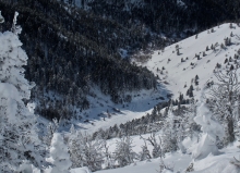
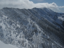
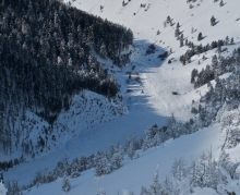
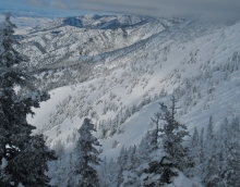
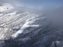
SS-N-R3-D2-I
Elevation: 9,200
Aspect: SW
Coordinates: 45.3539, -111.4050
Caught: 0 ; Buried: 0; Killed: 0
From an obs.: "Large crown in lower meadows west side of beehive basin above jack creek. Both meadows in lower fight of photo went. Southwest aspect. Far right meadow crown is visible and entire face went. Left meadow is hard to see but 1/3 of face slid. I would guess 3-6 foot crown from how visible it was from moonlight."
Another report: "Observed good size crowns from Beehive Basin Road. They were on the west side of the ridge dividing Beehive Basin and Jack Creek. They were not down to the ground but big and wide looked like probably all the recent snow from the storm."
More Avalanche Details
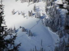
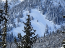
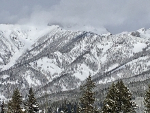
SS-N
Coordinates: 45.2366, -111.5060
Caught: 0 ; Buried: 0
"Looking out from Big Sky I noticed two (possibly connected) crowns near the ridge top."
More Avalanche Details
SS-AMu-R2-D1-I
Coordinates: 45.2890, -111.1410
Caught: 0 ; Buried: 0
A snowmobiler found very touchy conditions in Portal Creek. The new snow easily avalanched on road cuts so they went home.
More Avalanche Details