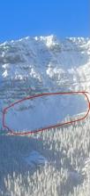
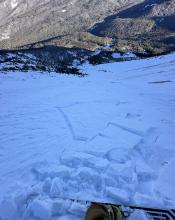
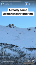
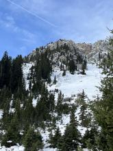
Avalanche Activity
Coordinates: 45.0202, -109.9380
Caught: 0 ; Buried: 0
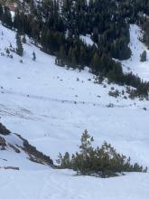
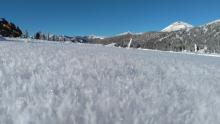
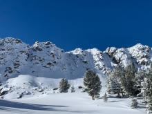
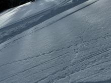
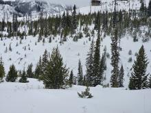
From obs: "Today (12/14) I was skiing a south facing slope between 8500-9500 ft near Mt Henderson. I observed at least ten large collapses, some of which sent cracks 30 feet long. This slope had a shallow snowpack relative to the rest of the area"
More Avalanche Details
Coordinates: 45.3407, -111.3910
Caught: 0 ; Buried: 0
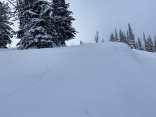
Skiers in Beehive Basin heard whumpfing while touring in Beehive Basin. Others saw poor stability test results with scores of ECTPV and ECTP1.
More Avalanche Details
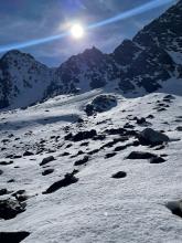
R2-D1.5
Coordinates: 44.7292, -111.3230
Caught: 0 ; Buried: 0
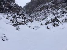
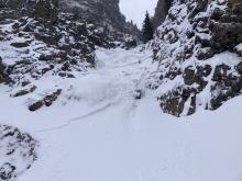
Two natural avalanches observed near Lionhead on 12/15 and another two observed by a separate group on 12/14. All occurred well below the high ridgelines and likely broke several days earlier.
From obs:"We rode up Denny Creek towards Watkins Creek and spent the day below the ridge where we saw two natural avalanches. These avalanches broke 12-18" deep on weak faceted snow above a stiff crust. The first avalanche presumably happened sometime near the end of the last storm cycle (12/11), as it had a few inches of snow on the debris. The second was more recent, in the last 24-36 hours. Both were at 8500' and were on NE and E-facing slopes. "
More Avalanche Details

Coordinates: 44.7016, -111.2930
Caught: 0 ; Buried: 0
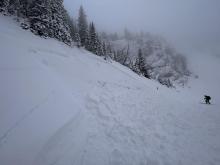
Spent the day up near ski hill with West Yellowstone Avalanche Fundamentals course.
Our group observed a large collapse below ski hill.
We dug various pits @ 8000' below ski hill and found HS 85-55cm on NW-NE aspects.
The snowpack structure there had weak snow at the ground capped by a stout ice crust with faceted snow over the crust beneath the recent snow.
We recorded ECTP4, ECTP11, ECT20 & a few more propagating results on facets above the crust.
There was widespread intact surface hoar.
More Avalanche Details
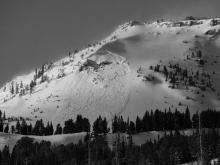
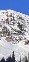
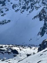
SS-ASu-R2-D2-O
Elevation: 9,800
Aspect: SE
Coordinates: 45.4444, -111.0040
Caught: 0 ; Buried: 0
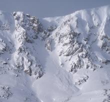
A skier triggered avalanche on the SE face of Mt. Blackmore. Crown is marked.
More Avalanche Details

Coordinates: 45.8156, -110.9230
Caught: 0 ; Buried: 0
Skinned up the closed ski area to the Fingers Meadow above the Pierres Knob chairlift. Got a substantial collapse (whumpf) while skinning and stopped to dig a pit at that location. E aspect, 8100 ft. Snowpack consisted of 6-8" of old, weak, faceted snow at the ground capped by ~18" of snow that has fallen over the last week.
ECT broke on the old snow while isolating the column. Twice (ECTPV x 2). Clear signs of instability kept us out of avalanche terrain.
More Avalanche Details
D2
Aspect: SE
Coordinates: 45.0423, -109.9650
Caught: 0 ; Buried: 0
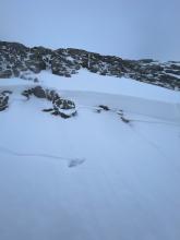
From email: "Noted one recent large slab avalanche on a SE aspect of Miller Ridge. Estimated to be about 100' wide and 1-4' deep. It ran about 1/3 track or 600' vert. No fresh snow on the debris, so it likely ran at the end of the last snowfall event."
Date is approximate.
More Avalanche Details
Coordinates: 45.0423, -109.9650
Caught: 0 ; Buried: 0
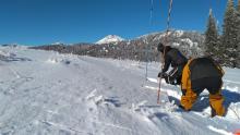
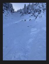
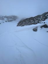
Lots of collapsing today near Miller Ridge (S, SE facing slopes), just 50' from the road. This continued in more sheltered areas as well. Dug on a NE facing slope at 9300', HS: 80 ECTP12 @ 40 cm.
More Avalanche Details
Coordinates: 45.4472, -110.9620
Caught: 0 ; Buried: 0
Got a view of the bowls behind maid of the mist and above twin falls today. Multiple natural wind slabs, up to size 2, on E and NE aspects, roughly 9500 ft. SS-N-R2D2-I. My guess is they are roughly 48 hrs old.
More Avalanche Details
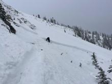
AS
Coordinates: 45.4444, -111.0040
Caught: 0 ; Buried: 0
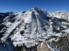
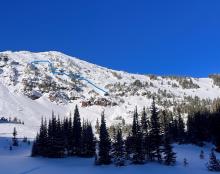
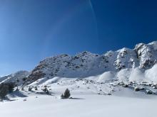
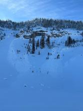
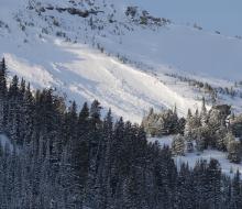
Toured up toward Mt. Blackmore today with the goal of skiing the mellow SE facing meadow and familiarizing myself with the current unstable snowpack. While stopping for lunch I dug a quick pit out of curiosity and performed a CT at 8757’ on a NW aspect with HS 85cm. Results were CT11 down 17 cm within the new snow on a hardness change and a CT13 down 35 cm on old facets. Moving farther up in the basin we noticed the pictured recent D2 avalanche on the E aspect of Blackmore. As we skinned up the SE meadow, we experienced three audible whumpfs. Otherwise great skiing was found today albeit a bit thin!
More Avalanche Details
Elevation: 8,700
Aspect: SE
Coordinates: 45.3407, -111.3910
Caught: 0 ; Buried: 0
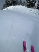
We skied into Beehive Basin today and found unstable snow. The bottom half of the 1.5' snowpack is weak, sugary facets that collapsed with audible "whumpfs" as we toured up...
More Avalanche Details

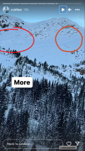
N
Aspect: SW
Coordinates: 45.3934, -110.9690
Caught: 0 ; Buried: 0
Skiers on 12/21 saw 2 old avalanches while skiing in the Divide Peak Cirque. These avalanches likely happened near the end of the last storm cycle, 12/9.
From obs: "Saw evidence of two natural avalanches on southwest aspects (see photos). The age of these slides was hard to gauge based on our lack of recent snow."
More Avalanche Details
N-R2-D2
Aspect: NE
Coordinates: 45.4160, -110.9980
Caught: 0 ; Buried: 0
Natural avalanche on Mt. Bole. Observed taken 12/14/23. Avalanche likely released the previous weekend, around 12/9/23.
From obs: "We were ice climbing on Mummy 3 and 4 yesterday and as we looked across the valley to Mount Bole, we could see evidence of avalanche activity on the NE aspect of the peak. It looked quite big in length but could tell a depth from that far away."
More Avalanche Details
AF
Coordinates: 45.4402, -110.9310
Caught: 0 ; Buried: 0
1 team yesterday (Saturday, not me) climbed Bobo Like and Big Sleep (first 2 pitches of each). They experienced 2x collapses but no other signed of instability.
More Avalanche Details
N
Coordinates: 45.3407, -111.3910
Caught: 0 ; Buried: 0
Skiers in Beehive basin observed a natural avalanche on Saturday 12/9
More Avalanche Details
SS-ASu-R2-D1.5
Coordinates: 45.8156, -110.9230
Caught: 0 ; Buried: 0
From email: "Solo skier that released a small pocket of snow at the bottom of Super Couloir - he was not caught and it was just the recent new snow and it didn't run far."
More Avalanche Details
SS-N-R1-D1
Coordinates: 45.0607, -111.2720
Caught: 0 ; Buried: 0
Riders in Taylor Fork saw natural avalanches on Saturday, 12/9
More Avalanche Details
AS
Coordinates: 44.8692, -111.2390
Caught: 0 ; Buried: 0
Skiers in the Southern Madison, Lionhead, and Northern Madison areas experienced widespread cracking and collapsing on Saturday 12/9.
More Avalanche Details
SS-AMr-R2-D2
Coordinates: 44.9041, -111.1850
Caught: 0 ; Buried: 0
Riders remotely triggered two avalanches while in Teepee Basin on 12/9
More Avalanche Details

AS
Elevation: 9,000
Coordinates: 45.0524, -109.9450
Caught: 0 ; Buried: 0
From email: "LOTs of collapsing again today while breaking trail on low angled S, E and W aspects. Some collapses were quite large (100'+ diameter)."
More Avalanche Details
Coordinates: 45.4360, -110.9830
Caught: 0 ; Buried: 0
Climbers in Hyalite saw a large natural avalanche on Elephant Mountain. 12/10
More Avalanche Details
SS-R3-D2-O
Elevation: 9,900
Aspect: SE
Coordinates: 45.0524, -109.9450
Caught: 0 ; Buried: 0
From email "Observed a fresh slab avalanche on Mt. Henderson this morning. E, SE aspect, 9,900'. I skied up to investigate it and would estimate the size of the crown to be 2-4' deep and about 80' wide. Somewhat surprised by the size relative to the starting zone. Likely a natural avalanche (from about 36 hrs ago), but there were fresh sled tracks in the vicinity from yesterday, so possibly a remote trigger."
More Avalanche Details
HS-ASc-R1-D2-O
Aspect: E
Coordinates: 45.2760, -111.4360
Caught: 0 ; Buried: 0
Big Sky Ski Patrol intentionally ski cut an avalanche breaking on the weak snow near the ground during avalanche mitigation work on 12/8/23.
From email: "[An avalanche] released on a ski cut, breaking on facets above a basal crust, easterly aspect, just below tree line."
More Avalanche Details
Coordinates: 45.6791, -111.0420
Caught: 0 ; Buried: 0
Cracking and collapsing reported across the advisory area in the Bridger Range, Big Sky area, near West Yellowstone and Island Park, and near Cooke City.
More Avalanche Details
SS-N-R1-D1-S
Coordinates: 45.4472, -110.9620
Caught: 0 ; Buried: 0
Upon descending climbers saw two recent natural avalanches in the Dribbles Gully. These avalanches were failing within the new snow.
More Avalanche Details
Aspect: E
Coordinates: 44.7145, -111.3180
Caught: 0 ; Buried: 0
Skiers in Lionhead saw old debris below Bald Peak on Wednesday, 12/13. This avalanche likely broke late last week, 12/7.
More Avalanche Details
ASu-R0-D1
Elevation: 8,500
Aspect: NE
Coordinates: 45.8156, -110.9230
Caught: 0 ; Buried: 0
From IG: Pocket I set off between finger 2 and 3 at Bridger Bowl just above the road. Finger 1 had someone ski it while we were hiking and they got a face wide crack.
More Avalanche Details
SS-N-R2-D1.5
Coordinates: 45.0524, -109.9450
Caught: 0 ; Buried: 0
From GNFAC: We rode up Daisy Pass road... saw a couple 8-10" deep natural avalanches on the steep slopes above Miller Creek that probably ran in the last 24-48hours. We had multiple collapses on the NE facing slope where we ski toured to dig our second pit.
More Avalanche Details
SS-AMu-R2-D1.5-O
Elevation: 9,000
Aspect: N
Coordinates: 45.0607, -111.2720
Caught: 0 ; Buried: 0
From text message: "The attached picture is a little slide that went off when I was doing small turns on an adjacent slope. That's Beaver Slide! There was more small slides south in the trees. Heard whumphing here and there." Photo: J. Onken
More Avalanche Details
Coordinates: 44.5168, -111.6300
Caught: 0 ; Buried: 0
User comment on FB: "Lotta slides in black canyon island park."
More Avalanche Details
Coordinates: 44.5168, -111.6300
Caught: 0 ; Buried: 0
From FB Comment: "We were seeing shooting cracks in the snow Sunday in the Black Canyon area."
More Avalanche Details
SS-ARu-R2-D2-O
Elevation: 9,000
Aspect: NE
Coordinates: 44.7145, -111.3180
Caught: 0 ; Buried: 0
Was splitboarding up near lions head ridge today. Made some bad decisions and kicked off a good slide in a NE facing chute. Was with 2 buddies, 1 of which skied the line 3 weeks ago. Underneath about a foot of new powder snow there was a firm crust that seemed like it was old hard windslab in the gut of the chute, and I think a sun crust on the riders left side(East aspect). We had 2 spots where we were planning to re group at, first was a small cubby area right before a slight rollover about 75 ft from the top. I dropped first, made some turns down toward the pulloff, as I pulled in, I triggered a good size slab that propagated maybe 40-50 ft across, at the rollover as I carved into the pulloff. Pulled all snow out of the chute down to the ground. Seemed to have failed on sugary facets on ground/ice crust close to the ground...
More Avalanche Details
Coordinates: 45.0202, -109.9380
Caught: 0 ; Buried: 0
Skied around Mt. Henderson today. Was finding around 28-35 cm of new snow at 9k'. Perhaps 10cms in town. Light density. Minor wind effect. Partly cloudy morning, turning mostly cloudy. Cold temps. Calm to light winds where I was, but lots of snow was being transported off the exposed ridgelines south of town. Quite a bit of cracking of the new snow this morning while breaking trail and while skiing, even though the wind effect was still Fist hardness. A couple of collapses noted as well in the deeper drifts.
More Avalanche Details
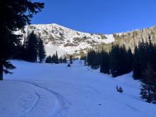
Coordinates: 45.0607, -111.2720
Caught: 0 ; Buried: 0
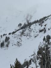
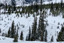
Went into the Lightning/Taylor Creek area of the Southern Madison’s in search of some powder skiing with the new snow. On our ascent toward Woodward Mountain via the backside, we found fresh snow varying from 2 inches at the trailhead to foot deep lightly drifted areas in the upper elevations. In the protected low angle gully we ascended this new snow sat atop either rocks or a very stout wind crust. The latter of which made for great skiing. We descended Woodward top down and assessed the possibility of thin (3”) wind slabs being reactive on the stout wind crust as the Woodward side seemed to have received a lot more loading from the storm’s E winds. As we rolled over to slightly steeper terrain, I noticed the snow stiffening just below my skis and gave it a few hops where I intentionally popped the pictured slab. With this information, we decided to carefully traverse to more protected trees and descend via a less wind loaded and hazardous route. We ski cut from tree to tree triggering a few more of these very small slabs before finding wonderful powder skiing lower on the mountain where the wind had significantly less effect.
All of the slabs were 1 to 4 inches deep and propagated 5 to 15 feet wide. None of them possessed the mass or were on steep enough terrain to overcome and slide over the stauch wall. Overall was a great lesson in mitigating hazard and we were rewarded with some great turns.
More Avalanche Details
N
Aspect: E
Coordinates: 45.4402, -110.9310
Caught: 0 ; Buried: 0
From FB message: "Hi! I’d like to report 2 natural slides that were witnessed in the Flanders fork of Hyalite on Friday 11/24 on the east facing aspect of the canyon. Both avalanches came from a single snow field above “Bobo Like” ice climb. These slides happened at approximately 7:45am and 8:15am"
More Avalanche Details
ASu-R2-D2-O
Elevation: 9,750
Aspect: E
Coordinates: 45.4443, -111.0020
Caught: 0 ; Buried: 0
Skiers reported triggering an avalanche on the east face of Mt. Blackmore on Sunday.
More Avalanche Details
N-R2-D2
Coordinates: 45.0524, -109.9450
Caught: 0 ; Buried: 0
Avalanches on Henderson Mountain near Cooke City were reported via instagram on 11/9/2023. Estimating they occurred a day earlier.
From message: "on Henderson in Cooke just above the lulu trail. It was surprising to see so much activity"
More Avalanche Details
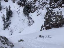
HS-ASu-R1-D1.5-O
Elevation: 9,000
Aspect: N
Coordinates: 45.8926, -110.9620
Caught: 1 ; Buried: 0
From observation: "Skier triggered windslab in the Great One off of Naya Nuki peak, skier was carried 15-20ft before arresting. Slide was triggered roughly halfway down the couloir where the right wall dips away exposing the snow to wind. Hard consolidated snow over facets, roughly 1-1.5 ft thick, ran about 50-100 ft before pouring over the cliff faces below. North- northeast aspect." 11/8/2023
More Avalanche Details
L-N-R1-D1-O
Elevation: 8,200
Aspect: NE
Coordinates: 45.8156, -110.9230
Caught: 0 ; Buried: 0
A hiker at Bridger Bowl noticed a small, loose snow avalanche near the Apron. Noting that it was a, "Good reminder as to how little snow is required to have an avalanche!"
More Avalanche Details
WL-N-R2-D2-G
Elevation: 9,500
Aspect: NW
Coordinates: 45.1628, -111.5290
Caught: 0 ; Buried: 0
From IG: “Pine creek today, some small wind slabs and a full depth wet slide off black mountain”
More Avalanche Details
WL-N-R1-D2-O
Elevation: 9,900
Aspect: N
Coordinates: 45.4457, -111.0040
Caught: 0 ; Buried: 0
From obs. (10/21): "Was out alpine climbing today and observed the north face of Blackmore had slid already."
More Avalanche Details