Avalanche Activity
L-N-R1-D1.5
Elevation: 8,000
Aspect: E
Coordinates: 45.7869, -110.9350
Caught: 0 ; Buried: 0
From obs 11/6/24: "Saw debris from several small natural avalanches below the ridge on an east aspect south of saddle peak while driving up to bridger. Most looked like point releases but there was one that might have been a small slab. Unsure because the light wasn't right to tell if there was a crown.
We stayed low but found a pretty uniform snowpack other than a couple of spots with sun crusts.
There was also tons of snow blowing over the ridge when we left around 3pm."
More Avalanche Details
SS-ASu-R2-D2-O
Elevation: 8,100
Aspect: NE
Coordinates: 45.8156, -110.9230
Caught: 0 ; Buried: 0
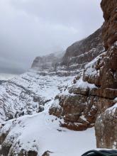
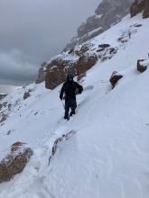
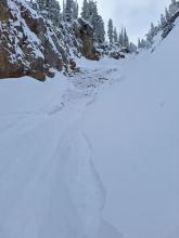
From IG Message: “Hey guys - my partner broke off a small avalanche in super couloir today… broke full depth across half the couloir, 2-3’ deep/20’ wide and looked like it ran around 500’. No one was caught. He might message you with pictures too but here’s a video from the top”
From IG Message: “Skier triggered Pocket in super couloir. Wasn't very unexpected, the skiers left side felt a little slabbier than the skiers right and tried to stay off it but got blinded by a sick face shot. Triggered going over a sharky rock spot, not very fast moving and easy to ski out of. Snow depth was 2-2.5 feet”
More Avalanche Details

Elevation: 9,400
Aspect: E
Coordinates: 45.3029, -110.6350
Caught: 0 ; Buried: 0
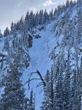
Avalanche observed on Chico Baldy above Mill Creek in Paradise Valley. East aspect at about 9400'. Possibly a wind slab but hard to tell
More Avalanche Details

HS-AF-R2-D1-I
Elevation: 9,600
Aspect: NW
Coordinates: 45.1582, -111.4770
Caught: 0 ; Buried: 0
Triggered a small wind slab:
-9600'
-N aspect on the NW ridge of Sphinx Mountain
-Strong SW wind
-Noticed other small crowns, likely triggered from another party traversing the north-facing bowl at similar elevations
More Avalanche Details