Photos

|
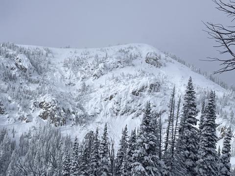
Lionhead Range, 2024-02-10 Two natural avalanches that likely happened in the last 24-48 hours. 500' wide. "Crown line extends basically the entire ridge in the background." Photo. H. Darby Link to Avalanche Details |

|
Lionhead Range, 2024-02-10 The crown of a natural avalanche likely happened in the last 12 hours. This avalanche broke 200' wide, 3-4' deep, and ran "almost full path" to the trees below. Photo: H. Darby
Link to Avalanche Details |

|
Out of Advisory Area, 2024-02-10 Debris from a remotely triggered avalanche that was 2-4' deep and broke 50' wide. Skiers triggered this from low-angle terrain 20' away. Photo: J. Alford Link to Avalanche Details |

|
Out of Advisory Area, 2024-02-10 The crown of a remotely triggered avalanche that was 2-4' deep and broke 50' wide. Skiers triggered this from low-angle terrain 20' away. Photo: J. Alford Link to Avalanche Details |

|
Southern Madison, 2024-02-10 Photo of a natural avalanche that was reported on 02/09/2024. Photo taken on 02/10/2024. Photo: Z. Peterson Link to Avalanche Details |

|
Southern Madison, 2024-02-10 Photo of a natural avalanche that was reported on 02/09/2024. Photo taken on 02/10/2024. Photo: Z. Peterson Link to Avalanche Details |

|
Southern Madison, 2024-02-09 A portion of the debris pile from a rider triggered an avalanche on 02/07/2024. This avalanche broke 3/4 of a mile wide and had multiple large piles of debris with this being one of the largest. Link to Avalanche Details |

|
Southern Madison, 2024-02-09 The contiuation of the crown of an avalanche that was remotely triggered by a rider on 02/07. This was a very wide avalanche that broke 3/4 of a mile long, 3-4' deep. Photo: GNFAC Link to Avalanche Details |

|
Southern Madison, 2024-02-09 The crown of an avalanche that was remotely triggered by a rider on 02/07. This was a very wide avalanche that broke 3/4 of a mile long, 3-4' deep. Photo: GNFAC Link to Avalanche Details |

|
Cooke City, 2024-02-09 A snowboarder triggered an avalanche from 100' away after feeling a "massive" collapse. Photo: N. Mattes Link to Avalanche Details |

|
Island Park, 2024-02-08 A small avalanche that was triggered by riders on 02/08/2024. Photo: GNFAC Link to Avalanche Details |

|
Island Park, 2024-02-08 This avalanche was triggered by riders a few days ago. This was a small slope and broke 100' wide and 2-3' deep. Photo: GNFAC Link to Avalanche Details |

|
Cooke City, 2024-02-08 Natural avalanche on East Side of Henderson Mtn. seen late on 2/7/24. South of the two that Doug saw last week, along the ridge. Could have happened yesterday or last night. I didn’t see it yesterday when riding up and down Fisher creek, but visibility was mediocre. The debris and bed had at least some new snow on it. Photo: GNFAC Link to Avalanche Details |

|
Cooke City, 2024-02-06 From obs: "Observed an avalanche above Highway 212 ("the plug") just north of the Wyoming/Montana border. that appeared to be triggered by a snowmobile. It looked fresh, likely from the afternoon of 2/6/2024. Northeast facing slope, 8200'. Technically out of the advisory area." Photo: N. Gaddy Link to Avalanche Details |

|
Cooke City, 2024-02-05 We had one collapse, 10-12' wide near treeline where there was a little more wind-loading/effect. Photo: GNFAC |

|
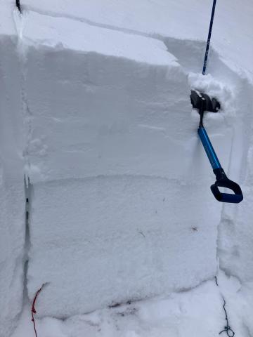
Cooke City, 2024-02-05 We dug a snowpit at 9,761' on a west facing slope south of Cooke City. ECTP21, 40 cm below the surface (16" down). There was 6-8" of new snow from the weekend above 4" of soft old snow, on top of 4" of a pencil- hard slab, then the soft sugary facets to the ground. ECT broke below the hard slab at the top of the facets. Photo: GNFAC |

|
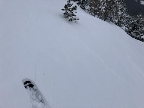
Southern Madison, 2024-02-05 This crack opened up above our snowpit as we made our exit away from the steeper terrain of the "Skillet" run toward low-angle trees. Photo: GNFAC Link to Avalanche Details |

|
Southern Madison, 2024-02-05 We triggered booming collapses and watched cracks shoot out across terrain features and snow shake off nearby trees for the entirety of our tour from the meadow near the car to the top of the Skillet. Photo: GNFAC Link to Avalanche Details |

|
Northern Madison, 2024-02-05 From obs 2/4/24: "Multiple natural avalanches and at least one suspected human triggered dry loose in Beehive Basin. Most naturals appeared to have run either last night or yesterday (2/3/24), with a couple potentially older slides. Suspect one skier trigged dry loose in W facing trees..." Photo: M. Zia Link to Avalanche Details |
