Good morning. This is Dave Zinn with the Gallatin National Forest Avalanche Forecast on Monday, February 20th at 7:00 a.m. This information is sponsored by Uphill Pursuits and Mystery Ranch. This forecast does not apply to operating ski areas.
AVALANCHE WARNING
The Gallatin National Forest Avalanche Center is issuing a Backcountry Avalanche Warning for the Bridger Range and the mountains around Cooke City. Heavy snowfall and strong winds in the last two days are creating very dangerous avalanche conditions. Natural and human-triggered avalanches are likely. Avalanche terrain and avalanche runout zones should be avoided. The avalanche danger is rated HIGH on all slopes. Contact the Gallatin National Forest Avalanche Center for more detailed information.
This warning will expire or be updated by 6:00 a.m. on Tuesday, February 21, 2023.
In the last 24 hours, the Bridger Range and Cooke City received 12” of new snow, with 7-9” in Big Sky and Hyalite Canyon, and 4-5” near West Yellowstone and in the Southern Madison and Southern Gallatin Ranges. Temperatures are in the teens to 20s F with 15-30 mph winds from the west to northwest. Snow will continue today with 4-7” in the mountains around Bozeman and Big Sky, 10” near West Yellowstone, and 20” near Cooke City possible by morning. Temperatures will be in the 20s to 30s F with 20-30 mph winds from the west to southwest.
Avalanche Warning
Very dangerous avalanche conditions exist in the Bridger Range and the mountains around Cooke City. Human-triggered and natural avalanches are likely. Give avalanche terrain a wide berth, by staying off and out from under any slope steeper than 30 degrees. The Bridger Range has received over 30” of snow, equal to 3.2” of snow water equivalent (SWE) since Saturday morning. The mountains near Cooke City received 14” of snow equal to 0.9” SWE, primarily in the last 24 hours. Winds gusting to 55 mph are drifting snow and adding additional load to slopes at all elevations. Avalanches within the new and wind-drifted snow will be dangerous. Slides could break on buried weak layers resulting in larger avalanches that run well into the flats below.
As we discussed in our video from the Throne in the Bridger Range yesterday, you don’t have to stay out of the backcountry, but you do need to stay away from all avalanche terrain (video).
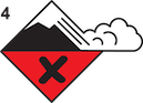
The avalanche danger is HIGH on all slopes.
The Gallatin and Madison Ranges received 10” of snow (0.9” of SWE) closer to West Yellowstone and 17” of snow (0.8-1.3” of SWE) near Big Sky and in Hyalite Canyon. Strong winds are building unstable drifts at all elevations and aspects. Continuing snowfall will load slopes to their breaking point. Human-triggered avalanches are likely within the new and wind-drifted snow. These will be enough to capture, carry and bury skiers or riders. Larger slides breaking on weak layers buried in the upper few feet of the snowpack are possible. Cautious route-finding, careful snowpack evaluation and conservative decision-making are essential.
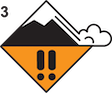
The avalanche danger is CONSIDERABLE on all slopes.

The Lionhead area received 7” of snow in the last 48 hours (0.6” SWE). Winds gusting to 55 mph are drifting and loading this snow onto slopes that could avalanche today. Avalanches within the drifted snow will be large enough to carry a rider or skier. Turn back from steep terrain if you observe signs of instability related to recent wind-loading, such as fresh avalanche activity, newly formed pillows of snow, or cracks shooting out from your sled or skis. Any of these signs should turn us back toward lower-angle slopes or non-wind-loaded areas. A rider-triggered slide in Airplane Bowl five days ago indicates the most likely type of avalanche today (details and photo). Deeper avalanches are unlikely but dig a quick snowpit and test for instability in the upper three feet of the snowpack before riding or skiing a steep slope.
The avalanche danger is MODERATE on all slopes.
Expect the avalanche danger to rise if snowfall today if snowfall intensifies.
Please share avalanche, snowpack or weather observations via our website, email (mtavalanche@gmail.com), phone (406-587-6984), or Instagram (#gnfacobs).

The Centennial Range received 5” of snow in the last 48 hours (0.4” SWE). Winds gusting to 55 mph are drifting and loading this snow onto slopes that could avalanche today. Turn back from steep terrain if you observe signs of instability related to recent wind-loading, such as fresh avalanche activity, newly formed pillows of snow, or cracks shooting out from your sled or skis. Deeper avalanches are unlikely but dig a quick snowpit and test for instability in the upper three feet of the snowpack before riding or skiing a steep slope.
Upcoming Avalanche Education and Events
Our education calendar is full of awareness lectures and field courses. Check it out: Events and Education Calendar.
March 3-5, Bozeman Splitfest. More info and register here.
Every Saturday, 10 a.m. - 2:00 p.m. Avalanche Rescue Training, drop in for any amount of time. Round Lake Warming Hut, Cooke City. Free.
Loss in the Outdoors, is a support group for those who have been affected by grief and loss related to outdoor pursuits. Check out the link for more information.
Bruce Jamieson’s videos on Snow Science explain heady topics to the layman. Understanding the avalanche dragon helps keep us alive.