Good morning. This is Ian Hoyer with a spring weather and snowpack update on Friday, April 29th. The Gallatin National Forest Avalanche Center has stopped issuing daily avalanche forecasts for the season. This is our final weather and snowpack update of the 2021/’22 season.
Unsettled weather beginning Wednesday brought a couple inches of snow to the mountains around Bozeman and Big Sky, with 5-10” near West Yellowstone and Cooke City. At lower elevations this precipitation fell as rain. Heavy snowfall is expected today around Bozeman and Big Sky with 4-8” falling by the end of the day. Only an inch or two will fall around West Yellowstone and Cooke City. Tomorrow will be sunny with temperatures above freezing. Sunday will be cloudy again with a sprinkling of snow possible.

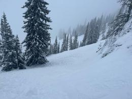
All Regions
In places where it is snowing heavily today, the avalanche hazard will rise quickly. Avalanches will be easily triggered in the new and wind drifted snow. The more snow that falls, the more dangerous conditions will become. If you find cohesive slabs of new snow more than a few inches deep, carefully check how well those slabs have bonded to the old snow surface before getting into steep terrain. Cracks shooting out in front of you are clear signs the new snow is unstable.
In general, you’re unlikely to trigger an avalanche breaking deeper than the new snow. However, on higher elevation shady slopes the snowpack remains cold, dry, and layered. On these slopes it’s not out of the question that you could trigger a deeper slide. Dig down a couple feet to look for weak layers and test them. If you find a reactive weak layer, back off of steep slopes for today.
When the sun comes out tomorrow, the new snow will quickly become wet and destabilize. Expect to trigger loose wet avalanches. These slides will entrain any new snow, so the deeper that new snow is, the larger these loose slides will be. Don’t discount loose avalanches. Even a relatively small slide can be hazardous if it pushes you off a cliff or into rocks or trees.
The snowpack doesn’t know how to read a calendar. Even though it’s late April and we’re now well into Spring, it’s still possible to trigger an avalanche. More important than today’s date is the fact that it is actively snowing. That means avalanches are becoming more likely. Keep sticking to the same safe travel practices that you follow mid-winter. Look for signs of instability and be ready to back off steep slopes if you find them. Always carry rescue gear (beacon, shovel, and probe). Go one at a time in avalanche terrain. And watch your partner from a safe spot.
This is our final snowpack update of the season. Have a great spring and summer! We’ll be back when it starts snowing again in the fall.
Announcements, Avalanche Education and Events
Bridger Bowl is closed, and backcountry conditions exist. There is no avalanche mitigation or ski patrol rescue. In case of emergency, call 911. Please stay clear of work areas, snowmobiles, chair lifts and other equipment. Without the daily avalanche mitigation efforts of the ski patrol, backcountry conditions now exist within the boundaries of Bridger Bowl (video). Commonly traveled routes such as the North Bowl Road and any slope steeper than 30 degrees are avalanche terrain (i.e. most of the Ridge and Schlasman’s terrain). Other groups above and below you may complicate principles of safe travel.
Snow will be around the mountains for a month or two and avalanches will continue. When warm temperatures return, wet snow hazards will increase. If there are big spring snowstorms, dangerous conditions may develop for new snow avalanches and wind slabs. With either extended warming or a big storm, there is still a lingering possibility of deep avalanches breaking on weak, sugary snow near the ground. See this article for some general spring travel advice.