Good morning. This is Dave Zinn with the Gallatin National Forest Avalanche Forecast on Tuesday, March 29th at 7:15 a.m. This information is sponsored by Highline Partners and Spark R&D. This forecast does not apply to operating ski areas.
Freezing levels are around 8000’ elevation this morning, with temperatures above this level ranging from the upper 20s to low 30s F. Winds are 5-10 mph from the west to northwest and the mountains around Bozeman and Big Sky received 1” of new snow this morning. Today, temperatures will be in the low to mid 30s F with northwest winds blowing 5-15 mph. The mountains around Bozeman and Big Sky will get 1-2” of snow this morning with a trace to 1” elsewhere.

Our level of uncertainty about the avalanche danger is relatively high today. A week of above freezing temperatures weakened the snowpack structure. Last night, elevations above 8000’ experienced below-freezing temperatures which is good for stability. This morning, precipitation started as rain in the Bridger Range before turning to snow. As the storm spreads south, rain will make your day less fun and further saturate and destabilize the snowpack. Conversely, slopes with a thick melt-freeze crust formed by cooler temperatures are more stable. Avoid avalanche terrain if you are breaking through the crust into unconsolidated wet snow remembering that the snowpack is less stable at lower elevations. As I noted from the Bridger Range yesterday, today is “Not your normal powder day.”
To understand how weak the snowpack got with the warm temperatures visit the avalanche activity log. There are fourteen entries from the last three days. A few highlights include a natural avalanche cycle in the Bridger Range (photos and details 1, 2, 3), wet snow avalanches intentionally triggered by the YCSP that buried a road (photos and details) and widespread terrain closures and natural inbounds avalanches at Big Sky, Bridger and Yellowstone Club (photos and details).
Careful snowpack evaluation, cautious route-finding and conservative decision-making are essential. The danger is CONSIDERABLE due to large variation between slopes at different elevations and a higher than normal level of uncertainty.

Temperatures in the higher elevations in the mountains around Cooke City dropped to the mid 20s F last night and are forecast to drop into the low 20s F by early afternoon. Lower elevations that didn’t get as cold are suspect for wet snow avalanches if you are breaking into unconsolidated wet snow.
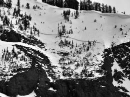
The high peaks did not escape the warmup without a wet avalanche cycle. Alex took photos of a couple of larger wet slab avalanches (photo) and many loose snow avalanches (photo) on his drive into Cooke City Sunday. Skiers captured some excellent images of yesterday’s avalanche activity (photos and details). Avoid steep slopes with unsupportable wet snow and on all others dig down to assess the snowpack for a persistent weak layer of facets under 1-3’ of snow that has resulted in recent avalanches including one that caught three skiers last Thursday (video, photos & details).
Human-triggered avalanches are possible in the mountains around Cooke City where the danger is rated MODERATE.
If you get out, please send us your observations no matter how brief. You can submit them via our website, email (mtavalanche@gmail.com), phone (406-587-6984), or Instagram (#gnfacobs).
Upcoming Education Opportunities
See our education calendar for an up-to-date list of all local classes.
This article in the Billings Gazette highlighting Dave’s January accident, shoulder injury and rescue is worth your time. Plan ahead and prepare for dealing with an injury in the backcountry and think about how you’d call for outside help.