Good morning. This is Dave Zinn with the Gallatin National Forest Avalanche Forecast on Tuesday, March 15th at 7:15 a.m. This information is sponsored by Montana State Parks and Uphill Pursuits. This forecast does not apply to operating ski areas.
This morning, mountain temperatures are in the high teens to high 20s F with 15-25 mph winds from the west to southwest and the Lionhead area received 2” of new snow. Today, temperatures will reach the mid 30s to mid 40s F with 15-25 mph winds from the southwest. Snowfall will fill in through the afternoon with 3-5” falling by tomorrow morning.

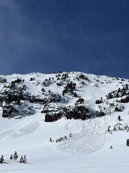
It is possible to trigger dangerous avalanches in the mountains around Cooke City after this weekend’s 13” of snow and associated wind (weather log). Slopes prone to wind loading or that have obvious drifts are the most likely to avalanche. Riding north of Cooke City yesterday, Alex saw natural and human-triggered avalanches mostly failing a foot deep, taking out the recent snow (photos and details, video). However, layers of weak snow buried around two feet deep make larger avalanches possible as Ian saw north of Scotch Bonnet last week (video). A dozen observed avalanches since Saturday paint a clear picture about the possibility of triggering slides (avalanche activity). Avalanches becoming less likely as the snowpack adjusts, but patience or a thorough snowpack assessment is vital.
Look for signs of instability and test the upper few feet of the snowpack looking for information telling you to stay off steep slopes. Safe travel protocols provide a buffer if your assessment is wrong.
Today, the danger is MODERATE in the mountains around Cooke City. Snowfall this afternoon will increase the avalanche danger.
It is possible to trigger avalanches 6-18” deep on a melt-freeze crust or a layer of weak facets in the mountains around Bozeman, Big Sky and West Yellowstone. Strong winds will transport snow onto slopes where avalanches are most likely. Yesterday, skiers triggered multiple avalanches on the east face of Mount Blackmore, one from 50’ away (photos and details), and a group of snowmobilers sent in a photo of a slide on a wind-loaded slope below a cornice near Buck Ridge (photos and details). Two days ago, a skier took a nasty ride and sustained minor injuries in the backcountry outside of Big Sky Resort on a heavily wind-loaded slope when he triggered a 1000’ wide avalanche that carried him over rocks (photos and details). Sunday, in Beehive Basin, my partner and I found weak snow and bailed to a lower angle slope due to unstable test results at the top of a steep slope (video).
Wet snow avalanches are possible, especially at lower elevations where temperatures will be warmer and precipitation may begin a rain.
Give yourself a chance to turn around by assessing the snowpack and looking for signs of instability before skiing or riding in avalanche terrain. The avalanche danger is MODERATE.
If you get out, please send us your observations no matter how brief. You can submit them via our website, email (mtavalanche@gmail.com), phone (406-587-6984), or Instagram (#gnfacobs).
Upcoming Education Opportunities
See our education calendar for an up-to-date list of all local classes. Here are a few select upcoming events.
Sadly, a snowmobiler was caught, buried and killed in an avalanche near Willow Park, Wyoming on Saturday. Our deep condolences go out to the family and friends of the rider. Preliminary information is available here.