Good morning. This is Doug Chabot with the Gallatin National Forest Avalanche Forecast on Thursday, March 10th at 7:00 a.m. This information is sponsored by Spark R&D and Highline Partners. This forecast does not apply to operating ski areas.
There’s no new snow this morning, just mountain temperatures of -15F. Wind is currently from the west to north and strongest in the Bridger Range (gusts of 42 mph) and Hyalite (gusts of 27 mph). The rest of the forecast area has 10-20 mph W-N wind. Wind is expected to stay the same as mountain temperatures touch the teens. Clear skies will become cloudy and tonight a trace to 1” of snow may fall.

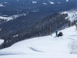
The mountains around Bozeman are windy at the ridgelines and also at lower elevations. This week’s 8-10” of powder snow is getting blown into drifts which could avalanche. Freshly formed wind slabs will be touchy and reactive to triggering. On Tuesday Dave triggered a small slide in Lick Creek on snow that was kissed by the wind (video) and yesterday skiers triggered a small avalanche on the approach to Mt. Blackmore (photo). Shooting cracks and recent avalanche activity are primary signs of instability today. Stay off of wind loaded, thicker drifts of snow. A -50F wind chill at the ridgeline will be a barrier to getting on many of these slopes. For today the avalanche danger is rated CONSIDERABLE on wind-loaded terrain and MODERATE on all others.

Monday and Tuesday's snow storm dropped 8-10” of snow in the mountains. On many slopes this fell onto a layer of weak, faceted, sugary snow, while on others it bonded onto an existing crust. A little investigation is in order before you commit to anything steep. Slopes might have sweet powder or they might have avalanche potential. Additionally, even the slightest hint of wind could build dangerous slabs. I found windy conditions at Lionhead yesterday (video, photo) and had drifts crack. Wind is currently light, but do not let your guard down. If you feel the snow under your machine or skis get denser and stiff, or if you witness shooting cracks, it’s a good idea to stay off of steep slopes. For today the danger is rated MODERATE since triggering avalanches is possible.
Ian and his partner rode and dug snow pits around Cooke City the last 2 days and found a thick slab of dense snow atop a weak layer of facets. This poor structure was responsible for many avalanches in the last 2 weeks. Ian checked out a slide that was triggered on Scotch Bonnet on Sunday (video) and also saw a thin wind slab avalanche on Henderson Mountain yesterday (photo). Triggering avalanches is not a sure thing, but this poor structure will take a long time to heal. The problem is ongoing and patience is the only way to deal with it. For today the avalanche danger is rated MODERATE since it remains possible to trigger avalanches.
If you get out, please send us your observations no matter how brief. You can submit them via our website, email (mtavalanche@gmail.com), phone (406-587-6984), or Instagram (#gnfacobs).
Upcoming Education Opportunities
See our education calendar for an up-to-date list of all local classes. Here are a few select upcoming events.
Every Saturday near Cooke City, 10 a.m.-3 p.m. FREE snowpack update and transceiver/rescue training. Stop by for 20 minutes or more at the Round Lake Warming Hut.
Here is an all-time favorite presentation on Decision-making in extreme situations. It was presented at a Professional Development Workshop in Bozeman in 2019.