Good morning. This is Dave Zinn with the Gallatin National Forest Avalanche Forecast on Tuesday, February 8th, at 7:15 a.m. This information is sponsored by Gallatin County Sheriff Search and Rescue and Mystery Ranch. This forecast does not apply to operating ski areas.
AVALANCHE FATALITY
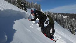
On Sunday, one snowmobiler in a group of four was caught and killed in a small avalanche on Ski Hill at the south end of Lionhead Ridge. He was on a steep, 45-degree wind-loaded slope when it released and partially buried him against a tree, a terrain trap. The slide was 4"-11" deep, 75 feet wide and ran 300 vertical feet. The avalanche was not witnessed and the victim was buried an estimated 15-25 minutes before he was uncovered. The shallow, steep slide partially buried the rider with his head a foot under the snow and resuscitation efforts were not successful. The group was familiar with the area and had rescue gear. Our deepest condolences go out to the family and friends of the rider. We will release a video today and a detailed accident report tomorrow. Preliminary details and pictures of the accident investigation are here.
This morning, temperatures are in the teens F and the wind is blowing 15-25 mph from the west to northwest. There is no new snow. Today, high temperatures will be in the upper 20s to mid 30s F with 10-25 mph winds from the west to southwest. Snowfall beginning late tonight will bring 2-4” to the Big Sky and Hyalite areas and a trace to 2” everywhere else by tomorrow morning.

Heavy snowfall last weekend resulted in both human-triggered and natural avalanches in the mountains around Cooke City. This instability will be slow to stabilize because of a persistent weak layer of sugary facets and feathery surface hoar buried 18-24” deep (photo). On Sunday, a small avalanche remotely triggered by a group of riders broke on the opposite side of the small hill they were playing on, showing the weak layer’s dangerous ability to communicate failure widely (photo). Yesterday, Alex rode around Cooke City and continued to get unstable test results, warning that conditions are going to stay unstable for a while (video). Look at the photos page on our website to see many images of avalanches in Cooke City from the last several days.
Dangerous, human-triggered slides remain possible and the danger is MODERATE. The danger will rise to CONSIDERABLE on wind-loaded slopes if forecasted winds begin loading snow into fresh drifts. Keep it simple by employing careful route finding and conservative decision-making to avoid avalanches today.

The snowpack in the Bridger, Madison and Gallatin Ranges and in the Lionhead Ridge area is mostly stable. While large avalanches are unlikely, there are two isolated problems. The first is a layer of weak snow buried 6-18” deep and the second is recent drifts created by strong winds. Two relatively small, snowmobile-triggered avalanches on Sunday show that isolated pockets of instability remain (details and photos). Unfortunately, one of these relatively small avalanches ended in tragedy when a rider was partially buried against a terrain trap of trees (limited details and photos). While this weak layer is widespread across the Lionhead area and in the Gallatin, Madison and Bridger Ranges, there is generally not enough of a slab on top of it to avalanche.
The wind has blasted the Northern Madison, Northern Gallatin and Bridger Ranges for days. Recent wind drifts are small and mostly stable but look for signs that small slabs could still break on underlying weak layers and consider terrain features that would make small slides unforgiving (photo).
Be on the lookout for these localized problems and hedge your bets by following safe travel protocols. Avalanches are unlikely and the danger is LOW.
If you get out, please send us your observations no matter how brief. You can submit them via our website, email (mtavalanche@gmail.com), phone (406-587-6984), or Instagram (#gnfacobs).
Upcoming Education Opportunities
See our education calendar for an up-to-date list of all local classes. Here are a few select upcoming
February 10th, Forecaster Chat at Uphill Pursuits, “Beyond the Beacon” with GNFAC Forecaster Dave Zinn
Every Saturday near Cooke City, 10 a.m.-3 p.m. FREE snowpack update and transceiver/rescue training. Stop by for 20 minutes or more at the Round Lake Warming Hut.
We are sad to report that on February 6th, a snowmobiler was caught by an avalanche in the Lionhead area outside of West Yellowstone. The rider was carried into trees and life-saving efforts on-scene were unsuccessful. Our deepest condolences go out to the family and friends of the rider (limited details and photos).
We will release further details in the coming days.