Good morning. This is Dave Zinn with the Gallatin National Forest Avalanche Forecast on Tuesday, January 18th at 7:00 a.m. This information is sponsored by the Community Food Co-op, the Upper Yellowstone Snowmobile Club and Gastrognome. This forecast does not apply to operating ski areas.
Temperatures this morning are in the teens F in West Yellowstone and Cooke City and in the mid 20s F everywhere else with 10-20 mph winds from the northwest to southwest. There is an inch of new snow in Cooke City and nothing anywhere else. Today, high temperatures will be in the mid 20s F with 5-15 mph winds from the southwest to northwest. Snow will begin this morning with 1-4” favoring the mountains around Bozeman and Cooke City.

All Regions
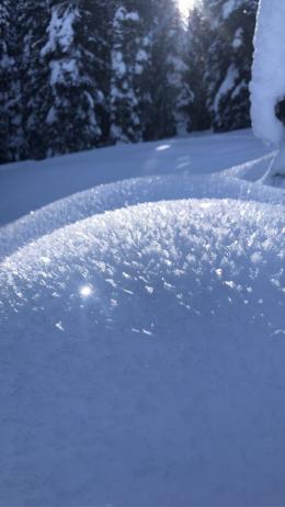
The snowpack across the advisory area is generally stable and the expected snow won’t be enough weight to change this. However, don’t mistake today’s overall stability to mean an absence of weak layers. Riders and skiers have spotted a feathery layer of weak surface hoar growing from West Yellowstone to Cooke City. When it gets buried today, this will be our new layer of concern until proven otherwise (Cooke photo, Lionhead photo 1, 2). It will not be a significant hazard with the minimal snow arriving today, but it will be as it gets buried deeper. Help us map its extent by letting us know if you see it on the surface or see shooting cracks and surprising reactivity in today’s inch or two of new snow.
Without significant new loading, Doug and Alex remind us to focus on the basics during times of low danger by testing the snowpack, assessing for isolated instabilities and employing safe travel practices (Doug in the Bridger Range, Alex in Cooke City). Groups in the Madison, Northern Gallatin and Bridger Ranges have reported snowpits that have failed and propagated in isolated areas, indicating a potentially unstable combination of a buried weak layer and an overlying slab of snow (photo). These groups (and all the ones who are reporting stable test results) are nailing it! They know that even though avalanches are generally unlikely, they need to test stability to make a slope-specific forecast before skiing or riding. If they identify areas of isolated instability, they go somewhere else. Keep it up.
Today, human-triggered avalanches are unlikely to break deeper than the 1-2” of new snow that falls during the day, and the danger is LOW.
If you get out, please send us your observations no matter how brief. You can submit them via our website, email (mtavalanche@gmail.com), phone (406-587-6984), or Instagram (#gnfacobs).
Upcoming Education Opportunities
The West Yellowstone Beacon Park is up and running! Stop by to check it out and practice with your rescue gear.
See our education calendar for an up-to-date list of all local classes. Here are a few select upcoming events and opportunities to check out:
January 20 + Field Day. Our popular Avalanche Fundamentals with Field Course is perfect as a refresher or an introduction to avalanches. We are introducing a new format with four pre-recorded lectures to watch at your convenience, a live question and answer session, and a choice of a snowmobile or ski/ board-based field day occurring the following two weekends.
Every Saturday near Cooke City, 10 a.m.-3 p.m. FREE snowpack update and transceiver/rescue training. Stop by for 20 minutes or more at the Round Lake Warming Hut.
As we wait for the next dump of snow, now is an excellent time to practice avalanche rescue. Are you fast and efficient with your beacon? Is your partner? Even the sharpest knife needs an occasional tune. Check out this BCA video to hone your skills.