Good morning. This is Ian Hoyer with the Gallatin National Forest Avalanche Forecast on Friday, December 31st at 7:00 a.m. This information is sponsored by Yellowstone Club Community Foundation and Montana State Parks. This forecast does not apply to operating ski areas.
The mountains around Cooke City have 9” of new snow, with 4-7” near West Yellowstone, and 2-4” near Bozeman and Big Sky. Winds have been 15-20 mph out of the west and southwest with gusts as high as 60 mph. Winds will calm dramatically this morning and shift to the north. Temperatures in the single digits this morning will fall throughout the day as a cold front moves through. Light snowfall today will bring 1-3” near West Yellowstone and Cooke City with only a trace around Bozeman and Big Sky.
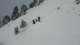
It just keeps snowing and blowing in the mountains near Cooke City and West Yellowstone. It has snowed 4-5 ft over the last week and a half accompanied by strong, generally westerly, winds piling that snow into deeper drifts. This has put a lot of weight on the snowpack and keeps the avalanche danger elevated. You are likely to trigger a large, dangerous avalanche if you travel on any steep wind-loaded slope. Avalanches could break on interfaces within the recent snow or on weak layers near the ground. Monday’s avalanche accident that killed two snowmobilers on a wind-loaded slope near Cooke City reminds us of the seriousness of our travel decisions (accident report). Dave and I were near Lionhead yesterday and the continued loading meant that even without signs of instability we still weren’t trusting the weak layers low in the snowpack (video). Avoid steep slopes that have been wind-loaded and carefully evaluate the snowpack before riding any steep slope. The danger is rated CONSIDERABLE on wind-loaded slopes and MODERATE on all others.

In the Bridger Range there is a layer of weak snow buried in the middle of the thin snowpack (video). This layer is reacting in stability tests and it is possible to trigger avalanches on it. Triggering avalanches in fresh wind drifts is also a possibility. Pay particular attention where these concerns overlap. Dig to search for the weak layer. Look for and pay attention under your feet or sled for the smooth, denser pillows of snow that indicate wind drifted snow. Human triggered avalanches are possible and the avalanche danger is MODERATE.
Strong winds and a bit of new snow have formed wind drifts that could be triggered by a skier or rider today. Look for these drifts near ridgelines, behind tree islands, and in gullies. Pay extra attention in high consequence terrain where even getting swept off your feet would put you into a bad situation. Until it gets substantially loaded, the lower snowpack is mostly stable. Human triggered avalanches are possible on wind-loaded slopes which have a MODERATE danger. On all other slopes the danger is rated LOW.
If you get out, please send us your observations no matter how brief. You can submit them via our website, email (mtavalanche@gmail.com), phone (406-587-6984), or Instagram (#gnfacobs).
Upcoming Education Opportunities
Get your avalanche brain ready for the season at one of the many classes listed on our education calendar, and list of upcoming events below.
January 20 + Field day. Our popular Avalanche Fundamentals with Field Course is perfect as a refresher or an introduction to avalanches. We are introducing a new format with four pre-recorded lectures to watch at your convenience, a live question and answer session, and a choice of a snowmobile or ski/ board based field day occurring the following two weekends.
Every Saturday near Cooke City, 10 a.m.-3 p.m. FREE snowpack update and transceiver/rescue training. Stop by for 20 minutes or more at the Round Lake Warming Hut.
On Monday, December 27th, two snowmobilers were caught and killed in an avalanche on Scotch Bonnet Mountain, north of Cooke City. We have completed our report, which is available HERE.