Good morning. This is Dave Zinn with the Gallatin National Forest Avalanche Forecast on Tuesday, December 28th at 7:00 a.m. This information is sponsored by World Boards and Uphill Pursuits. This forecast does not apply to operating ski areas.
AVALANCHE FATALITY
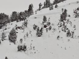
We are sad to report that yesterday, December 27th, two snowmobilers were caught and killed in an avalanche on Scotch Bonnet Mountain to the north of Cooke City. At the time of the avalanche, four riders were on the slope. Two were able to escape. All eight members of the group had rescue equipment. The avalanche broke 5’ deep and approximately 300’ wide on a southeast-facing slope.
Members of Park County Sheriff Search and Rescue arrived to assist with rescue and recovery efforts.
Our deepest condolences go out to the victim’s friends and family, members of the group and the search and rescue community. Doug and Ian are in Cooke City now and we will release further details as they become available.
The mountains around West Yellowstone and Cooke City received 2-3” of new snow yesterday with 0-1” in the mountains near Bozeman and Big Sky. High temperatures reached the single digits to low teens F before plunging back to the single digits below 0 F and winds were 10-20 mph from the west to northwest. Today, temperatures will be in the single digits above 0 F with 10-20 mph wind from the west. By morning, there will be 1-2” of new snow in the mountains across the advisory area with more tomorrow.
The mountains around Cooke City and West Yellowstone and the Southern Madison and Southern Gallatin Ranges picked up 2-3” of new snow bringing the storm totals to 33-40” of new snow in the last week (2.8-3.7” of snow water equivalent - SWE). Tragically, two snowmobilers died in an avalanche yesterday on Scotch Bonnet Mountain north of Cooke City (details and photos). Another group of skiers near Henderson Bench reported a natural avalanche likely triggered by a cornice fall that broke 5-6’ deep on buried weak layers near the ground (details and photo).
The same fundamental structure and loading patterns resulting in avalanches near Cooke City exist in the Lionhead area (video), the Southern Madison (video) and the Southern Gallatin Ranges. Human-triggered avalanches are likely where winds from the last week drifted the 3’ of new snow onto steep slopes. Avalanches may break within the layers of new snow and wind-drifted snow or 5-6’ deep on weak layers buried in the lower third of the snowpack. Keep it simple and avoid steep wind-loaded slopes. Avalanches are possible on non-wind-loaded slopes where you should utilize thorough snowpack assessments, consider the consequences of the terrain and follow safe travel protocols.
You can ride and ski safely today. Avalanches occur in terrain that is 30 degrees and steeper or areas immediately below these steep slopes. Utilize an inclinometer and measure slope angles frequently.
The danger is CONSIDERABLE on wind-loaded slopes and MODERATE on all others.

The mountains around Bozeman and Big Sky got 5-9” of new snow in the last two days equal to 0.4-0.6” of SWE. Skiers at Mount Blackmore noted that recent winds had affected the snow surface and concerns about wind-loaded terrain kept them off steep faces. The Big Sky and Bridger Bowl Ski Patrols both triggered 12-24” deep slides on wind-loaded slopes during routine avalanche mitigation with some breaking across a wide area. Today, human-triggered avalanches are possible in wind-loaded terrain. Most likely they would be similar to the natural avalanche on Saddle Peak on Christmas day (photo), but weaker layers of snow in the lower in the snowpack could fail on heavily wind-loaded slopes. With less active wind-loading today, look for other clues to identify areas with recent wind-loading such as cornices, snow stiffening under your feet or sled and shooting cracks.
Avalanches are unlikely in non-wind-loaded terrain as we discuss in our videos from Saddle Peak, Buck Ridge and Beehive Basin. Yesterday, standard safe travel protocols and a good snowpack assessment kept a group of skiers out of steep terrain and away from terrain traps in the Northern Gallatin Range when they found a poor snowpack structure, even though they had stable test results. Utilize these strategies for your mountain travel.
The danger is MODERATE on wind-loaded terrain and LOW elsewhere.
If you get out, please send us your observations no matter how brief. You can submit them via our website, email (mtavalanche@gmail.com), phone (406-587-6984), or Instagram (#gnfacobs).
Upcoming Education Opportunities:
Get your avalanche brain ready for the season at one of the many classes listed on our education calendar, and list of upcoming events below.
Every Saturday near Cooke City, 10 a.m.-3 p.m. FREE snowpack update and transceiver/rescue training. Stop by for 20 minutes or more at the Round Lake Warming Hut.
Friends of GNFAC Powder Blast Fundraiser
THANK YOU! The Friends of the Avalanche Center arrived at our $65,000 goal for the Virtual Powder Blast fundraiser. Your donations will support free and low-cost avalanche education, beacon checkers at trailheads, beacon parks, weather stations, and GNFAC programs
We will continue to provide updates on the fatal accident in Cooke City as we get more information. Preliminary information and photographs of the avalanche are on our website. Doug and Ian are in Cooke City now completing an accident investigation at the site of the slide.